File:Thames Estuary and Wind Farms from Space NASA.jpg
跳转到导航
跳转到搜索

本预览的尺寸:750 × 600像素。 其他分辨率:300 × 240像素 | 600 × 480像素 | 960 × 768像素 | 1,280 × 1,024像素 | 2,560 × 2,048像素 | 5,000 × 4,000像素。
原始文件 (5,000 × 4,000像素,文件大小:2.34 MB,MIME类型:image/jpeg)
说明
说明
添加一行文字以描述该文件所表现的内容
摘要
[编辑]
| 描述 |
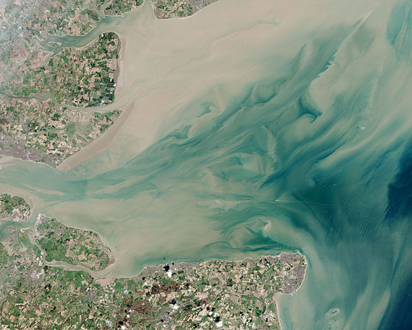
English: Thames Estuary and Wind Farms from Space NASA. Windfarms visible in the image are: London Array, Thanet Wind Farm, Kentish Flats Wind Farm and Gunfleet Sands Wind Farm. |
| 日期 | |
| 来源 | http://earthobservatory.nasa.gov/IOTD/view.php?id=82844 |
| 作者 | Operational Land Imager |
| 其他版本 |
 (with annotations) |
| 相机位置 | | 在以下服务上查看本图像和附近其他图像: OpenStreetMap |
|---|
许可协议
[编辑]
| 本文件完全由NASA创作,在美国属于公有领域。根据NASA的版权方针,NASA的材料除非另有声明否则不受版权保护。(参见Template:PD-USGov/zh、NASA版权方针页面或JPL图片使用方针。) | ||
 |
警告:
|
文件历史
点击某个日期/时间查看对应时刻的文件。
| 日期/时间 | 缩略图 | 大小 | 用户 | 备注 | |
|---|---|---|---|---|---|
| 当前 | 2015年6月22日 (一) 21:10 | | 5,000 × 4,000(2.34 MB) | Delusion23(留言 | 贡献) | User created page with UploadWizard |
您不可以覆盖此文件。
文件用途
以下5个页面使用本文件:
全域文件用途
以下其他wiki使用此文件:
- ceb.wikipedia.org上的用途
- cy.wikipedia.org上的用途
- en.wikipedia.org上的用途
- en.wikibooks.org上的用途
- es.wikipedia.org上的用途
- eu.wikipedia.org上的用途
- fa.wikipedia.org上的用途
- ga.wikipedia.org上的用途
- it.wikipedia.org上的用途
- ko.wikipedia.org上的用途
- ne.wikipedia.org上的用途
- ru.wikipedia.org上的用途
- sl.wikipedia.org上的用途
- sv.wikipedia.org上的用途
- uk.wikipedia.org上的用途
- www.wikidata.org上的用途
- zh.wikipedia.org上的用途
元数据
分类:
- Files with coordinates missing SDC location of creation (51° N, 1°E)
- Gunfleet Sands Wind Farm
- Kentish Flats Offshore Wind Farm
- Thanet Wind Farm
- London Array offshore wind farm
- Thames Estuary
- Isle of Sheppey
- Satellite pictures by Landsat 8
- Landsat images of the United Kingdom
- Satellite pictures of the North Sea
- Satellite pictures of England
- April 2013 in England