File:Thames Estuary and Wind Farms from Space NASA.jpg
跳至導覽
跳至搜尋

預覽大小:750 × 600 像素。 其他解析度:300 × 240 像素 | 600 × 480 像素 | 960 × 768 像素 | 1,280 × 1,024 像素 | 2,560 × 2,048 像素 | 5,000 × 4,000 像素。
原始檔案 (5,000 × 4,000 像素,檔案大小:2.34 MB,MIME 類型:image/jpeg)
說明
說明
添加單行說明來描述出檔案所代表的內容
摘要
[編輯]
| 描述 |
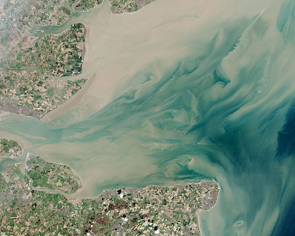
English: Thames Estuary and Wind Farms from Space NASA. Windfarms visible in the image are: London Array, Thanet Wind Farm, Kentish Flats Wind Farm and Gunfleet Sands Wind Farm. |
| 日期 | |
| 來源 | http://earthobservatory.nasa.gov/IOTD/view.php?id=82844 |
| 作者 | Operational Land Imager |
| 其他版本 |
 (with annotations) |
| 拍攝地點 | | 位於此地的本圖片與其他圖片: OpenStreetMap |
|---|
授權條款
[編輯]
| 本作品由NASA創作,屬於公有領域。根據NASA的版權政策:“NASA的創作除非另有聲明否則不受版權保護。”(參見:Template:PD-USGov/zh,NASA版權政策或JPL圖像使用政策) | ||
 |
警告:
|
檔案歷史
點選日期/時間以檢視該時間的檔案版本。
| 日期/時間 | 縮圖 | 尺寸 | 用戶 | 備註 | |
|---|---|---|---|---|---|
| 目前 | 2015年6月22日 (一) 21:10 | | 5,000 × 4,000(2.34 MB) | Delusion23(對話 | 貢獻) | User created page with UploadWizard |
無法覆蓋此檔案。
檔案用途
下列5個頁面有用到此檔案:
全域檔案使用狀況
以下其他 wiki 使用了這個檔案:
- ceb.wikipedia.org 的使用狀況
- cy.wikipedia.org 的使用狀況
- en.wikipedia.org 的使用狀況
- en.wikibooks.org 的使用狀況
- es.wikipedia.org 的使用狀況
- eu.wikipedia.org 的使用狀況
- fa.wikipedia.org 的使用狀況
- ga.wikipedia.org 的使用狀況
- it.wikipedia.org 的使用狀況
- ko.wikipedia.org 的使用狀況
- ne.wikipedia.org 的使用狀況
- ru.wikipedia.org 的使用狀況
- sl.wikipedia.org 的使用狀況
- sv.wikipedia.org 的使用狀況
- uk.wikipedia.org 的使用狀況
- www.wikidata.org 的使用狀況
- zh.wikipedia.org 的使用狀況
詮釋資料
分類:
- Files with coordinates missing SDC location of creation (51° N, 1°E)
- Gunfleet Sands Wind Farm
- Kentish Flats Offshore Wind Farm
- Thanet Wind Farm
- London Array offshore wind farm
- Thames Estuary
- Isle of Sheppey
- Satellite pictures by Landsat 8
- Landsat images of the United Kingdom
- Satellite pictures of the North Sea
- Satellite pictures of England
- April 2013 in England