File:Tharsis - Valles Marineris MOLA shaded colorized zoom 32.jpg
來自Wikimedia Commons
跳去導覽
跳去搵嘢

預覽大細:800 × 587 像素。 第啲解像度:320 × 235 像素 | 640 × 469 像素 | 1,024 × 751 像素 | 1,280 × 939 像素 | 2,560 × 1,877 像素 | 5,700 × 4,180 像素。
原本檔案 (5,700 × 4,180 像素,檔案大細:11.69 MB ,MIME類型:image/jpeg)
File information
Structured data
Captions
Captions
Add a one-line explanation of what this file represents
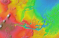
Relief map of the western hemisphere of Mars
Topografisk karta över Mars västra halvklot, med Tharsis-platån och Valles Marineris.
摘要[編輯]
| 描述Tharsis - Valles Marineris MOLA shaded colorized zoom 32.jpg |
English: Mars Orbiter Laser Altimeter (MOLA) colorized topographic map of the western hemisphere of Mars, showing the Tharsis and Valles Marineris regions. The impact basin Argyre is at lower right. Many of the features on this map are annotated in Wikimedia Commons. |
| 日期 | |
| 來源 | JMARS |
| 作者 | NASA / JPL-Caltech / Arizona State University |
| Other versions |
  |
協議[編輯]
| Public domainPublic domainfalsefalse |
| This file is in the public domain in the United States because it was solely created by NASA. NASA copyright policy states that "NASA material is not protected by copyright unless noted". (See Template:PD-USGov, NASA copyright policy page or JPL Image Use Policy.) |  | |
 |
Warnings:
|
4254
2058
78
85
5700
4180
Orson Welles (crater)
164
1666
64
78
5700
4180
Pettit (crater)
檔案歷史
撳個日期/時間去睇響嗰個時間出現過嘅檔案。
| 日期/時間 | 縮圖 | 尺寸 | 用戶 | 註解 | |
|---|---|---|---|---|---|
| 現時 | 2013年2月13號 (三) 04:02 |  | 5,700 × 4,180(11.69 MB) | WolfmanSF(傾偈 | 貢獻) | Slightly larger view to include the entire east-west extent of the western hemisphere, and to center the equator. |
| 2013年2月9號 (六) 10:15 |  | 5,040 × 4,000(9.81 MB) | WolfmanSF(傾偈 | 貢獻) | User created page with UploadWizard |
你無得衾咗個檔案。
檔案用途
全域檔案使用情況
下面嘅維基都用緊呢個檔案:
- ar.wikipedia.org嘅使用情況
- azb.wikipedia.org嘅使用情況
- az.wikipedia.org嘅使用情況
- be.wikipedia.org嘅使用情況
- el.wikipedia.org嘅使用情況
- en.wikipedia.org嘅使用情況
- es.wikipedia.org嘅使用情況
- et.wikipedia.org嘅使用情況
- fr.wikipedia.org嘅使用情況
- fr.wikibooks.org嘅使用情況
- hu.wikipedia.org嘅使用情況
- ja.wikipedia.org嘅使用情況
- ko.wikipedia.org嘅使用情況
- mk.wikipedia.org嘅使用情況
- pl.wikipedia.org嘅使用情況
- ru.wikipedia.org嘅使用情況
- sv.wikipedia.org嘅使用情況
- ta.wikipedia.org嘅使用情況
- th.wikipedia.org嘅使用情況
- uk.wikipedia.org嘅使用情況
- www.wikidata.org嘅使用情況
- zh-yue.wikipedia.org嘅使用情況
- zh.wikipedia.org嘅使用情況
Metadata
呢個檔案有額外嘅資料。佢應該係數碼相機或者掃描器整出來嘅。如果佢整咗之後畀人改過,裏面嘅資料未必同改過之後相符。
| 攞放方向 | 正常 |
|---|---|
| 橫解像度 | 72.009 dpi |
| 直解像度 | 72.009 dpi |
| 用過嘅軟件 | Adobe Photoshop Elements 9.0 Windows |
| 檔案更動日期時間 | 2013年2月12號 (二) 19:55 |
| 色彩空間 | sRGB |
| 影像闊度 | 5,700 px |
| 影像高度 | 4,180 px |
| 制成數碼日期時間 | 2013年2月9號 (六) 01:42 |
| Date metadata was last modified | 2013年2月12號 (二) 11:55 |
| Unique ID of original document | xmp.did:33D4D8C29075E211903F9DA78E7F30BB |