File:Tharsis Quadrangle map-la.svg
跳至導覽
跳至搜尋

此 SVG 檔案的 PNG 預覽的大小:800 × 534 像素。 其他解析度:320 × 214 像素 | 640 × 428 像素 | 1,024 × 684 像素 | 1,280 × 855 像素 | 2,560 × 1,710 像素 | 1,217 × 813 像素。
原始檔案 (SVG 檔案,表面大小:1,217 × 813 像素,檔案大小:489 KB)
說明
說明
添加單行說明來描述出檔案所代表的內容
摘要
[編輯]
| 描述 |
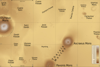
English: Map of Tharsis quadrangle on Mars planet, 90° to 135° west longitude and 0° to 30° north latitude. Latin (also international) version.
Français : Carte du quadrangle de Tharsis sur la planète Mars, de 90° à 135° de longitude ouest et de l'équateur à 30° de latitude nord. Version latine (et aussi internationale). |
| 日期 | (UTC) |
| 來源 | |
| 作者 |
|
| 火星上的位置 | | 位於此地的本圖片與其他圖片: Google地图 |
|---|
授權條款
[編輯]
我,本作品的著作權持有者,決定用以下授權條款發佈本作品:
This file is licensed under the Creative Commons Attribution-Share Alike Attribution-Share Alike 4.0 International, 3.0 Unported, 2.5 Generic, 2.0 Generic and 1.0 Generic license.
- 您可以自由:
- 分享 – 複製、發佈和傳播本作品
- 重新修改 – 創作演繹作品
- 惟需遵照下列條件:
- 姓名標示 – 您必須指名出正確的製作者,和提供授權條款的連結,以及表示是否有對內容上做出變更。您可以用任何合理的方式來行動,但不得以任何方式表明授權條款是對您許可或是由您所使用。
- 相同方式分享 – 如果您利用本素材進行再混合、轉換或創作,您必須基於如同原先的相同或兼容的條款,來分布您的貢獻成品。
| 本圖像屬於公有領域,因其為NASA的World Wind衛星地圖瀏覽器的一張截圖,且使用了公有領域圖層,如Blue Marble、MODIS、Landsat、SRTM、USGS、GLOBE等。
|
 |
您可以選擇您需要的授權條款。
原始上傳日誌
[編輯]
This image is a derivative work of the following images:
- File:Olympus_Mons_Region_map-la.svg licensed with Cc-by-sa-3.0,2.5,2.0,1.0, PD-WorldWind
- 2010-05-31T09:22:21Z Sémhur 2000x1500 (503869 Bytes) Fossea => Fossae
- 2010-05-25T18:26:08Z Sémhur 2000x1500 (493868 Bytes) Oups ! Chevauchement de textes
- 2010-05-25T18:22:39Z Sémhur 2000x1500 (493940 Bytes) Update few labels
- 2010-05-25T15:42:52Z Sémhur 2000x1500 (504578 Bytes) Update altitude max, from http://pubs.usgs.gov/imap/i2782/i2782_sh2.pdf
- 2009-07-08T18:43:58Z Sémhur 2000x1500 (502473 Bytes) * Arcia -> Arsia * Scale
- 2009-07-07T19:59:19Z Sémhur 2000x1500 (502588 Bytes) =={{int:filedesc}}== {{Information |Description= {{en|1=Map of [[:en:Olympus Mons|Olympus Mons]] and [[:en:Tharsis Montes|Tharsis Montes]] region, on Mars planet. Latin (also international) version.}} {{fr|1=Carte de la régi
Uploaded with derivativeFX
檔案歷史
點選日期/時間以檢視該時間的檔案版本。
| 日期/時間 | 縮圖 | 尺寸 | 使用者 | 備註 | |
|---|---|---|---|---|---|
| 目前 | 2012年12月2日 (日) 18:59 | | 1,217 × 813(489 KB) | Szczureq(留言 | 貢獻) | Uranius Patera -> Uranius Mons, Équateur -> 0° |
| 2010年5月31日 (一) 12:02 |  | 1,217 × 813(489 KB) | Sémhur(留言 | 貢獻) | + legend & coordinates | |
| 2010年5月31日 (一) 11:52 |  | 1,217 × 813(487 KB) | Sémhur(留言 | 貢獻) | =={{int:filedesc}}== {{Information |Description= {{en|1=Map of Tharsis quadrangle on Mars planet, 90° to 135° west longitude and 0° to 30° north latitude. Latin (also international) version.}} {{fr|1=Carte du [[:fr:Quadrangl |
無法覆蓋此檔案。
檔案用途
沒有使用此檔案的頁面。
全域檔案使用狀況
以下其他 wiki 使用了這個檔案:
- de.wikipedia.org 的使用狀況
- en.wikipedia.org 的使用狀況
- es.wikipedia.org 的使用狀況
- fr.wikipedia.org 的使用狀況
- gl.wikipedia.org 的使用狀況
- pl.wikipedia.org 的使用狀況
- pt.wikipedia.org 的使用狀況
- sv.wikipedia.org 的使用狀況
- uk.wikipedia.org 的使用狀況
- zh.wikipedia.org 的使用狀況