File:Tharsis Quadrangle map-la.svg
跳转到导航
跳转到搜索

此SVG文件的PNG预览的大小:800 × 534像素。 其他分辨率:320 × 214像素 | 640 × 428像素 | 1,024 × 684像素 | 1,280 × 855像素 | 2,560 × 1,710像素 | 1,217 × 813像素。
原始文件 (SVG文件,尺寸为1,217 × 813像素,文件大小:489 KB)
说明
说明
添加一行文字以描述该文件所表现的内容
摘要
[编辑]
| 描述 |
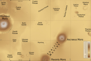
English: Map of Tharsis quadrangle on Mars planet, 90° to 135° west longitude and 0° to 30° north latitude. Latin (also international) version.
Français : Carte du quadrangle de Tharsis sur la planète Mars, de 90° à 135° de longitude ouest et de l'équateur à 30° de latitude nord. Version latine (et aussi internationale). |
| 日期 | (UTC) |
| 来源 | |
| 作者 |
|
| 火星上的位置 | | 在以下服务上查看本图像和附近其他图像: Google地图 |
|---|
许可协议
[编辑]
我,本作品著作权人,特此采用以下许可协议发表本作品:
This file is licensed under the Creative Commons Attribution-Share Alike Attribution-Share Alike 4.0 International, 3.0 Unported, 2.5 Generic, 2.0 Generic and 1.0 Generic license.
- 您可以自由地:
- 共享 – 复制、发行并传播本作品
- 修改 – 改编作品
- 惟须遵守下列条件:
- 署名 – 您必须对作品进行署名,提供授权条款的链接,并说明是否对原始内容进行了更改。您可以用任何合理的方式来署名,但不得以任何方式表明许可人认可您或您的使用。
- 相同方式共享 – 如果您再混合、转换或者基于本作品进行创作,您必须以与原先许可协议相同或相兼容的许可协议分发您贡献的作品。
| 本图像属于 w:公有领域 ,因其为 NASA 的 World Wind 卫星地图浏览器的一张截图,且使用了公有领域图层,如 Blue Marble、MODIS、Landsat、SRTM、USGS、GLOBE 等。
|
 |
您可以选择您需要的许可协议。
原始上传日志
[编辑]
This image is a derivative work of the following images:
- File:Olympus_Mons_Region_map-la.svg licensed with Cc-by-sa-3.0,2.5,2.0,1.0, PD-WorldWind
- 2010-05-31T09:22:21Z Sémhur 2000x1500 (503869 Bytes) Fossea => Fossae
- 2010-05-25T18:26:08Z Sémhur 2000x1500 (493868 Bytes) Oups ! Chevauchement de textes
- 2010-05-25T18:22:39Z Sémhur 2000x1500 (493940 Bytes) Update few labels
- 2010-05-25T15:42:52Z Sémhur 2000x1500 (504578 Bytes) Update altitude max, from http://pubs.usgs.gov/imap/i2782/i2782_sh2.pdf
- 2009-07-08T18:43:58Z Sémhur 2000x1500 (502473 Bytes) * Arcia -> Arsia * Scale
- 2009-07-07T19:59:19Z Sémhur 2000x1500 (502588 Bytes) =={{int:filedesc}}== {{Information |Description= {{en|1=Map of [[:en:Olympus Mons|Olympus Mons]] and [[:en:Tharsis Montes|Tharsis Montes]] region, on Mars planet. Latin (also international) version.}} {{fr|1=Carte de la régi
Uploaded with derivativeFX
文件历史
点击某个日期/时间查看对应时刻的文件。
| 日期/时间 | 缩略图 | 大小 | 用户 | 备注 | |
|---|---|---|---|---|---|
| 当前 | 2012年12月2日 (日) 18:59 | | 1,217 × 813(489 KB) | Szczureq(留言 | 贡献) | Uranius Patera -> Uranius Mons, Équateur -> 0° |
| 2010年5月31日 (一) 12:02 |  | 1,217 × 813(489 KB) | Sémhur(留言 | 贡献) | + legend & coordinates | |
| 2010年5月31日 (一) 11:52 |  | 1,217 × 813(487 KB) | Sémhur(留言 | 贡献) | =={{int:filedesc}}== {{Information |Description= {{en|1=Map of Tharsis quadrangle on Mars planet, 90° to 135° west longitude and 0° to 30° north latitude. Latin (also international) version.}} {{fr|1=Carte du [[:fr:Quadrangl |
您不可以覆盖此文件。
文件用途
没有页面使用本文件。
全域文件用途
以下其他wiki使用此文件:
- de.wikipedia.org上的用途
- en.wikipedia.org上的用途
- es.wikipedia.org上的用途
- fr.wikipedia.org上的用途
- gl.wikipedia.org上的用途
- pl.wikipedia.org上的用途
- pt.wikipedia.org上的用途
- sv.wikipedia.org上的用途
- uk.wikipedia.org上的用途
- zh.wikipedia.org上的用途