File:The Banc d'Arguin National Park, Mauritania (cropped).jpg

Fichier d’origine (2 539 × 3 605 pixels, taille du fichier : 1,14 Mio, type MIME : image/jpeg)
Légendes
Légendes
Description
[modifier]| Description |
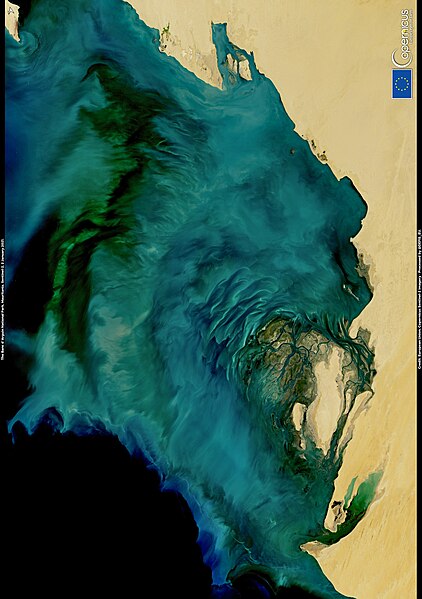
English: This image, acquired on 2 January 2021 by one of the Copernicus Sentinel-2 satellites, shows the Banc d'Arguin National Park off the coast of Mauritania. The Banc d'Arguin National Park is a UNESCO World Heritage Site. It is the major breeding site for migratory birds from northern Europe, Siberia and Greenland, including flamingos, broad-billed sandpipers, pelicans and terns. The surrounding waters are amongst the richest fishing waters in western Africa and serve as nesting grounds for the entire region. The bloom in the waters of the Banc D’Arguin visible in this image is due to a combination of phytoplankton and sediments. The particular climatic conditions of the area allow a continuous mixing of the cold and nutrient-rich waters, facilitating a persistent phytoplankton bloom throughout the year. Blooms are indicators of the health of a marine ecosystem, and therefore, their monitoring is a key component of effective management of coastal and oceanic resources. The Copernicus Sentinel missions provide high frequency data useful for monitoring the water quality of coastal waters. |
| Date | Prise le 2 janvier 2021 |
| Source | The Banc d'Arguin National Park, Mauritania |
| Auteur | European Union , Copernicus Sentinel-2 imagery |

.jpg&action=edit§ion=1)
Conditions d’utilisation
[modifier].jpg&action=edit§ion=2)

|
This image contains data from a satellite in the Copernicus Programme, such as Sentinel-1, Sentinel-2 or Sentinel-3. Attribution is required when using this image.
Attribution: Contains modified Copernicus Sentinel data 2021
The use of Copernicus Sentinel Data is regulated under EU law (Commission Delegated Regulation (EU) No 1159/2013 and Regulation (EU) No 377/2014). Relevant excerpts:
Free access shall be given to GMES dedicated data [...] made available through GMES dissemination platforms [...].
Access to GMES dedicated data [...] shall be given for the purpose of the following use in so far as it is lawful:
GMES dedicated data [...] may be used worldwide without limitations in time.
GMES dedicated data and GMES service information are provided to users without any express or implied warranty, including as regards quality and suitability for any purpose. |
Historique du fichier
Cliquer sur une date et heure pour voir le fichier tel qu'il était à ce moment-là.
| Date et heure | Vignette | Dimensions | Utilisateur | Commentaire | |
|---|---|---|---|---|---|
| actuel | 27 octobre 2023 à 12:56 | | 2 539 × 3 605 (1,14 Mio) | Rémih (d | contributions) | File:The Banc d'Arguin National Park, Mauritania.jpg cropped 30 % horizontally, -42 % vertically, rotated 270° using CropTool with precise mode. |
Vous ne pouvez pas remplacer ce fichier.
Utilisations locales du fichier
La page suivante utilise ce fichier :
Utilisations du fichier sur d’autres wikis
Les autres wikis suivants utilisent ce fichier :
- Utilisation sur fr.wikipedia.org
.jpg&oldid=882842592)