File:The Citadel of Alanya.jpg
Archivo original (1000 × 750 píxeles; tamaño de archivo: 360 kB; tipo MIME: image/jpeg)
Leyendas
Leyendas
Resumen[editar]
| Descripción |
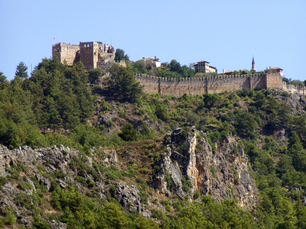
The citadel viewed from the city. The Citadel of Alanya, the walls of which are nearly 6.5 kilometres long, is on a peninsula whose height is up to 250 metres from the sea level. Although the settlement on Alanya peninsula, also known as Kandeleri, dates back to the Hellenistic Era, its cultural characteristics that can be seen today are thanks to Selcuks of the 13th century. The citadel was constructed on the demand of the Sultan of Selcuks, Alaaddin Keykubat, who conquered and had the city rebuilt in 1221. The citadel has 83 towers and 140 bastions. Nearly 400 cisterns were built to supply the city surrounded by walks in the medieval times with water. Some of the cisterns are still used today. The Seljuk Empire used Alanya as a second capital city in addition to Konya and used the city as a winter residence and made improvements there. Mongol attacks in 1243 and the Invasion of Anatolia by Egyptian Memluks weakened the Seljuk Empire which was divided in 1300, and the region came under the reign of the Karamano?ullar? dynasty. In 1427 Alanya was sold to the Memluk Sultan for five thousand gold pieces, and then in 1471 the city was included within the borders of the Ottoman Empire by Mehmet II The Conqueror. ( www.alanya.com.tr/en/47-Historical-Places.html ) |
| Fecha | |
| Fuente |
Türkiye - The Citadel of Alanya
|
| Autor | Robin & Bazylek from Kraków, Poland |
| Posición de la cámara | | Ubicación de esta y otras imágenes en: OpenStreetMap |
|---|
Licencia[editar]
- Eres libre:
- de compartir – de copiar, distribuir y transmitir el trabajo
- de remezclar – de adaptar el trabajo
- Bajo las siguientes condiciones:
- atribución – Debes otorgar el crédito correspondiente, proporcionar un enlace a la licencia e indicar si realizaste algún cambio. Puedes hacerlo de cualquier manera razonable pero no de manera que sugiera que el licenciante te respalda a ti o al uso que hagas del trabajo.
| Esta imagen, originalmente subida a Flickr, fue revisada el April 21, 2009 por el administrador o revisor File Upload Bot (Magnus Manske), quien comprobó que el archivo se encontraba disponible en Flickr bajo la licencia nombrada en dicha fecha. |
Historial del archivo
Haz clic sobre una fecha y hora para ver el archivo tal como apareció en ese momento.
| Fecha y hora | Miniatura | Dimensiones | Usuario | Comentario | |
|---|---|---|---|---|---|
| actual | 15:59 21 abr 2009 | | 1000 × 750 (360 kB) | File Upload Bot (Magnus Manske) (discusión | contribs.) | {{Information |Description= The citadel viewed from the city. The Citadel of Alanya, the walls of which are nearly 6.5 kilometres long, is on a peninsula whose height is up to 250 metres from the sea level. Although the settlement on Alanya peninsula, a |
No puedes sobrescribir este archivo.
Usos del archivo
La siguiente página usa este archivo:
Uso global del archivo
Las wikis siguientes utilizan este archivo:
- Uso en ar.wikipedia.org
- Uso en ba.wikipedia.org
- Uso en de.wikipedia.org
- Uso en es.wikipedia.org
- Uso en fr.wikipedia.org
- Uso en hu.wikipedia.org
- Uso en hy.wikipedia.org
- Uso en pt.wikipedia.org
- Uso en ru.wikipedia.org
- Uso en tg.wikipedia.org