File:The Man in the High Castle Plausible World Map.png
ナビゲーションに移動
検索に移動
このプレビューのサイズ: 800 × 579 ピクセル。 その他の解像度: 320 × 232 ピクセル | 640 × 463 ピクセル | 1,024 × 741 ピクセル | 1,280 × 926 ピクセル | 1,577 × 1,141 ピクセル。
元のファイル (1,577 × 1,141 ピクセル、ファイルサイズ: 400キロバイト、MIME タイプ: image/png)
キャプション
キャプション
このファイルの内容を1行で記述してください
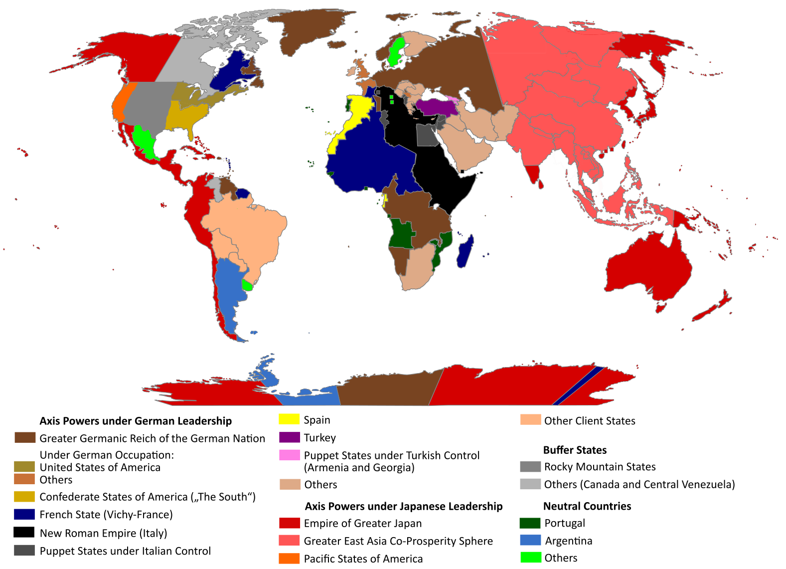
This map is an attempt to show the political situation described in the novel "The Man in the High Castle". It is however speculative, containing material and denomination of states which are not addressed in the book

|
This map, as well as other fictitious maps, is fictitious or too incorrect (i.e. due to anachronism) to be used in real-life contexts (contemporary or historic). It may have some visual elements that are similar to official maps such as colors or certain layout features, but they are NOT official and don't have any official recognition. |
[[Category:]]
概要[編集]
| 解説 |
English: "The Man in the High Castle" is an alternate history novel by Philip K. Dick. It is set in a world in which the Axis powers have won World War II. This map is inspired by Dick's story and shows a plausible division of the world between Nazi Germany (dark brown), Imperial Japan (dark red) and their respective allies. However, the map is much more precise than the book describes.
https://web.archive.org/web/20191202005150/http://www.high-castle-world-map.com:80/ |
| 日付 | |
| 原典 | 投稿者自身による著作物 |
| 作者 | RobintheHighCastle |
| 許可 (ファイルの再利用) |
ライセンス[編集]
この作品の著作権者である私は、この作品を以下のライセンスで提供します。
このファイルはクリエイティブ・コモンズ 表示-継承 4.0 国際ライセンスのもとに利用を許諾されています。
- あなたは以下の条件に従う場合に限り、自由に
- 共有 – 本作品を複製、頒布、展示、実演できます。
- 再構成 – 二次的著作物を作成できます。
- あなたの従うべき条件は以下の通りです。
- 表示 – あなたは適切なクレジットを表示し、ライセンスへのリンクを提供し、変更があったらその旨を示さなければなりません。これらは合理的であればどのような方法で行っても構いませんが、許諾者があなたやあなたの利用行為を支持していると示唆するような方法は除きます。
- 継承 – もしあなたがこの作品をリミックスしたり、改変したり、加工した場合には、あなたはあなたの貢献部分を元の作品とこれと同一または互換性があるライセンスの下に頒布しなければなりません。
ファイルの履歴
過去の版のファイルを表示するには、その版の日時をクリックしてください。
| 日付と時刻 | サムネイル | 寸法 | 利用者 | コメント | |
|---|---|---|---|---|---|
| 現在の版 | 2021年10月29日 (金) 14:55 | | 1,577 × 1,141 (400キロバイト) | Saltner67 (トーク | 投稿記録) | Added the portoguese colonies Cabinda and Ajuda since they would still have existed in this world. |
| 2021年6月20日 (日) 08:05 |  | 1,613 × 1,143 (417キロバイト) | Gernsback67 (トーク | 投稿記録) | Changed "Greater Asian Co-Prosperity Sphere" in "Greater East Asia Co-Prosperity Sphere", which is correct. | |
| 2020年10月16日 (金) 15:30 |  | 1,611 × 1,138 (418キロバイト) | Saltner67 (トーク | 投稿記録) | Restored the latest version. Please do not revert any changes, which have been made to this file so far, without any communication with the author of the map. All changes made here have been initialized by the author and are a result of the same process which has led to the creation of the map in the first place. | |
| 2020年10月16日 (金) 08:25 |  | 1,621 × 1,137 (392キロバイト) | Gooduserdude (トーク | 投稿記録) | RV Original research: this image is based on a source and should not be altered | |
| 2020年3月29日 (日) 14:15 |  | 1,611 × 1,138 (418キロバイト) | Saltner67 (トーク | 投稿記録) | Improved the accuracy of borders of Mongolia and Manchukuo. | |
| 2020年3月27日 (金) 15:58 |  | 1,607 × 1,138 (418キロバイト) | Saltner67 (トーク | 投稿記録) | Enlarged Manchukuo and added the puppet states of Yakutia and Krasnoyarsk/Irkutsk after more research on Kantokuen. | |
| 2020年3月12日 (木) 19:07 |  | 1,612 × 1,143 (411キロバイト) | Saltner67 (トーク | 投稿記録) | Moved the Swiss Canton of Valais from Germany to Italy, as has been prepared in the plans for Operation Tannenbaum. | |
| 2020年2月8日 (土) 18:57 |  | 1,605 × 1,139 (411キロバイト) | Saltner67 (トーク | 投稿記録) | Reinserted the territories of Tunisia,Greece, Crete and Cyprus after research on the Italian plannings and Greece in WWII. | |
| 2019年11月21日 (木) 13:21 |  | 1,611 × 1,133 (409キロバイト) | Gernsback67 (トーク | 投稿記録) | Enlarged Mongolia again after more research on pan-mongolism. | |
| 2019年9月21日 (土) 15:13 |  | 1,610 × 1,137 (408キロバイト) | Saltner67 (トーク | 投稿記録) | unified Mongolia, enlarged Manchukuo and Thailand, re-inserted the real-life borders of Laos and Vietnam after research on Demchugdongrub, Kantokuen, Thailand and Indochina in WWII |
このファイルは上書きできません。
ファイルの使用状況
このファイルを使用しているページはありません。
グローバルなファイル使用状況
以下に挙げる他のウィキがこの画像を使っています:
- ar.wikipedia.org での使用状況
- cs.wikipedia.org での使用状況
- da.wikipedia.org での使用状況
- de.wikipedia.org での使用状況
- en.wikipedia.org での使用状況
- en.wikiquote.org での使用状況
- es.wikipedia.org での使用状況
- gl.wikipedia.org での使用状況
- he.wikipedia.org での使用状況
- hu.wikipedia.org での使用状況
- it.wikipedia.org での使用状況
- ja.wikipedia.org での使用状況
- ko.wikipedia.org での使用状況
- lt.wikipedia.org での使用状況
- nl.wikipedia.org での使用状況
- pl.wikipedia.org での使用状況
- pt.wikipedia.org での使用状況
- ro.wikipedia.org での使用状況
- ru.wikipedia.org での使用状況
- th.wikipedia.org での使用状況
- uk.wikipedia.org での使用状況
- zh-classical.wikipedia.org での使用状況
- zh.wikipedia.org での使用状況