File:Ticsani.jpg
Z projektu Wikimedia Commons
Skočit na navigaci
Skočit na vyhledávání
Ticsani.jpg (640 × 453 pixelů, velikost souboru: 76 KB, MIME typ: image/jpeg)
Informace o souboru
Strukturovaná data
Popisky
Popisky
Přidejte jednořádkové vysvětlení, co tento soubor představuje
Popis[editovat]
| PopisTicsani.jpg |
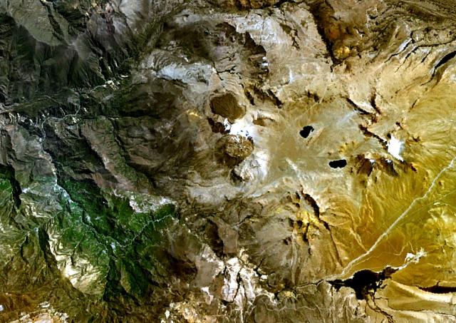
English: The Ticsani dacitic lava dome complex (center) lies ESE of Arequipa SE of the Río Putina (upper left) about 50 km east of the main volcanic front of the Peruvian Andes. A fresh-looking lava field forms the dark-colored area north of the main edifice in this NASA Landsat image (with north to the top). No historical eruptions are known from Ticsani, but fumarolic activity continues. |
| Datum |
neznámé datum Unknown date |
| Zdroj | http://www.volcano.si.edu/world/volcano.cfm?vnum=1504-031&volpage=photos&photo=114099 |
| Autor | NASA Landsat7 image (worldwind.arc.nasa.gov) |
| Pozice objektu | 16° 46′ 24,77″ j. š., 70° 36′ 26,58″ z. d. | Tento snímek a mnohé další na: OpenStreetMap |
|---|
Licence[editovat]
| Public domainPublic domainfalsefalse |
| This image is in the public domain because it is a screenshot from NASA’s globe software World Wind using a public domain layer, such as Blue Marble, MODIS, Landsat, SRTM, USGS or GLOBE.
العربيَّة | English | فارسی | français | עברית | македонски | മലയാളം | Nederlands | русский | 中文(中国大陆) | +/− |
Historie souboru
Kliknutím na datum a čas se zobrazí tehdejší verze souboru.
| Datum a čas | Náhled | Rozměry | Uživatel | Komentář | |
|---|---|---|---|---|---|
| současná | 20. 7. 2010, 08:25 |  | 640 × 453 (76 KB) | Michael Metzger (diskuse | příspěvky) | {{Information |Description={{en|1=The Ticsani dacitic lava dome complex (center) lies ESE of Arequipa SE of the Río Putina (upper left) about 50 km east of the main volcanic front of the Peruvian Andes. A fresh-looking lava field forms the dark-colored a |
Tento soubor nemůžete přepsat.
Využití souboru
Na Commons na soubor odkazuje tato stránka:
Globální využití souboru
Tento soubor využívají následující wiki:
- Využití na arz.wikipedia.org
- Využití na cs.wikipedia.org
- Využití na de.wikipedia.org
- Využití na en.wikipedia.org
- Využití na es.wikipedia.org
- Využití na fa.wikipedia.org
- Využití na no.wikipedia.org
- Využití na pl.wikipedia.org
- Využití na qu.wikipedia.org
- Využití na sk.wikipedia.org
- Využití na www.wikidata.org
- Využití na zh.wikipedia.org
Metadata
Tento soubor obsahuje dodatečné informace, poskytnuté zřejmě digitálním fotoaparátem nebo scannerem, kterým byl pořízen. Pokud byl soubor od té doby změněn, některé údaje mohou být neplatné.
| _error | 0 |
|---|

