File:Tide legal use.gif
Salta a la navegació
Salta a la cerca
No hi ha cap versió amb una resolució més gran.
Tide_legal_use.gif (720 × 477 píxels, mida del fitxer: 31 Ko, tipus MIME: image/gif)
Llegendes
Llegendes
Afegeix una explicació d'una línia del que representa aquest fitxer
Resum
[modifica]
| Descripció |
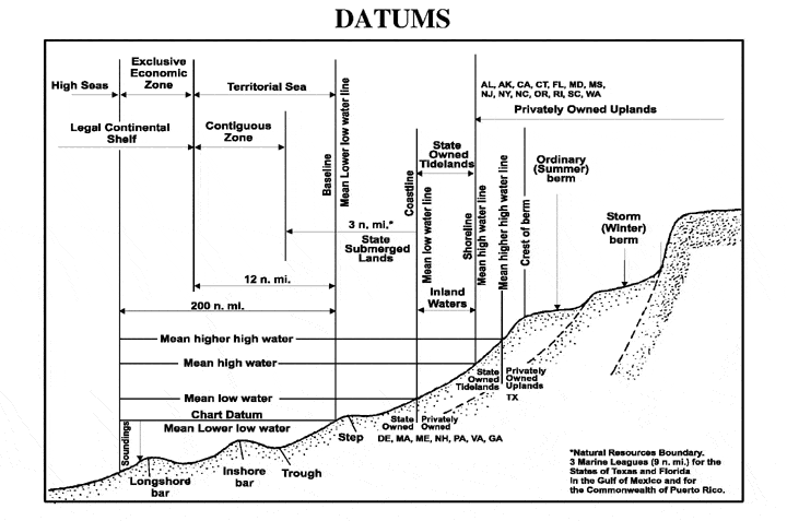
English: The principal tidal data related to a beach profile. The intersection of the tidal datum with land determines the landward edge of a marine boundary. |
| Font |
From NOS Tidal Datums Pub (on Naval Postgraduate School). http://www.oc.nps.navy.mil/nom/day1/partc.html figure:a http://www.oc.nps.navy.mil/nom/day1/tidal_datums_fig17.gif |
| Autor |
Llicència
[modifica]
Aquesta imatge és obra d'un mariner o empleat de l'U.S. Navy feta durant la prestació oficial de servei. Com a obra del govern federal dels EUA, la imatge és en el domini públic.
|
 | |
| Aquest fitxer està identificat com a lliure de restriccions conegudes sota la llei de drets d'autor, inclosos els drets veïns. | ||
Registre original de càrregues
[modifica]
Transferred from en.wikipedia to Commons using For the Common Good.
La pàgina de descripció original era aquí. Els noms d'usuari a continuació es refereixen a en.wikipedia.
| Data/hora | Dimensions | Usuari/a | Comentari |
|---|---|---|---|
| 00:41, 12 April 2007 | 720 × 477 (31,829 bytes) | w:en:Rmo13 (discussió | contribucions) | page: The principal tidal datums related to a beach profile. The intersection of the tidal datum with land determines the landward edge of a marine boundary. From NOS Tidal Datums Pub (on Naval Postgraduate School). http://www.oc.nps.navy.mil/nom/day1/par |
Historial del fitxer
Cliqueu una data/hora per veure el fitxer tal com era aleshores.
| Data/hora | Miniatura | Dimensions | Usuari/a | Comentari | |
|---|---|---|---|---|---|
| actual | 16:16, 20 nov 2016 | | 720 × 477 (31 Ko) | Mcapdevila (discussió | contribucions) | Transferred from en.wikipedia: see original upload log above |
No podeu sobreescriure aquest fitxer.
Ús del fitxer
No hi ha pàgines que utilitzin aquest fitxer.
Ús global del fitxer
Utilització d'aquest fitxer en altres wikis:
- Utilització a ca.wikipedia.org
- Utilització a cs.wikipedia.org
- Utilització a en.wikipedia.org
- Utilització a fa.wikipedia.org
- Utilització a fr.wikipedia.org
- Utilització a vi.wikipedia.org
- Utilització a zh.wikipedia.org