File:Timor-Leste Geological map of zone A.png
Zur Navigation springen
Zur Suche springen
Größe dieser Vorschau: 800 × 566 Pixel. Weitere Auflösungen: 320 × 226 Pixel | 640 × 453 Pixel | 1.024 × 724 Pixel | 1.280 × 906 Pixel | 2.560 × 1.811 Pixel | 2.923 × 2.068 Pixel.
Originaldatei (2.923 × 2.068 Pixel, Dateigröße: 1,35 MB, MIME-Typ: image/png)
Bildtexte
Kurzbeschreibungen
Ergänze eine einzeilige Erklärung, was diese Datei darstellt.
Beschreibung
[Bearbeiten]
| Beschreibung |
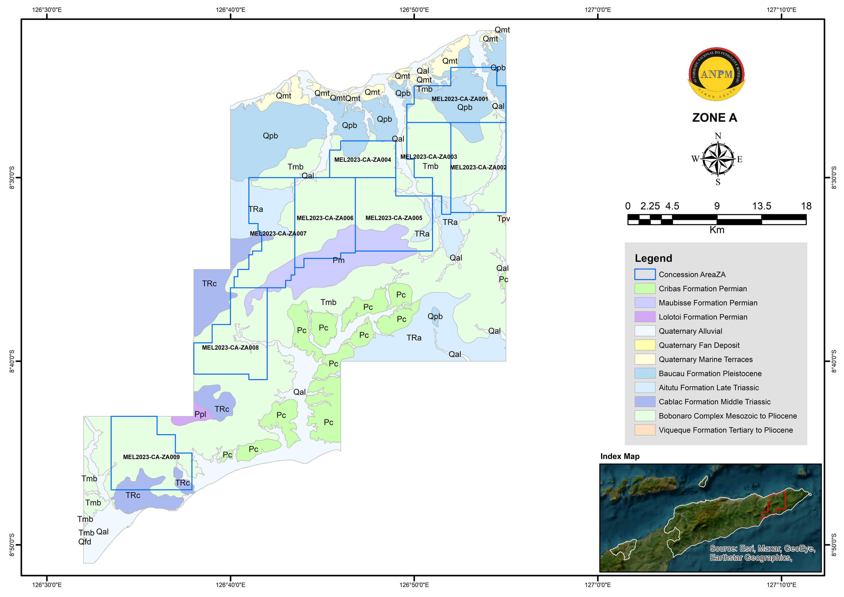
English: Zone A is located mainly within the area of Lautem Municipality and small part of the Viqueque and Baucau Municipalities with the estimated total area of 1114.65 km2. It has a total of nine (9) concession areas on offer for tender. The surface geology of this zone is primarily consist of Bobonaro Complex, Baucau Formation, Aitutu Formation, and Cablac Formation, with minor Lolotoi Formation, Maubisse Formation, Quaternary Alluvial and Quaternary Marine Terraces deposit (Figure 3). The lithologies that made up these formations are mainly sedimentary rocks such as limestone, sandstone, and marl, while the Bobonaro Complex contain various type of rocks of varying ages in scaly clay matrix.
Rock formations such as the Bobonaro Complex and Maubisse Formation are associated with high magnetic anomalies within the zones. The high magnetic anomalies correspond to the indication of potential metallic minerals and igneous rock present within the zone. Previous studies had noted that Zone A has indication for potential for minerals such as gold, chromium, manganese, and iron sand in part of the area including non-metallic minerals such as limestone and marble (UN-ESCAP 2003, IPG 2020; KARVAK 2022). |
| Datum | |
| Quelle | Autoridade Nacional dos Minerais |
| Urheber | Autoridade Nacional do Petróleo e Minerais |
Lizenz
[Bearbeiten]
This file is in the public domain in East Timor, because it is published and distributed by the Government of Democratic Republic of Timor-Leste, according to Article 13 of the Indonesia Copyright Law No 6, 1982, which was still valid in East Timor from independence on 20 May 2002 until 27 May 2023.[1]
There shall be no infringement of Copyright for:
|
 |
 |
Nach U.S. Circ. 38a. haben die folgenden Staaten weder die Berner Übereinkunft noch ein anderes Urheberrechtsabkommen unterzeichnet:
Urheberrechtsansprüche dieser Staaten, dies betrifft Werke, die von Staatsbürgern eines dieser Staaten innerhalb ihres Landes veröffentlicht werden, werden in anderen Staaten nicht anerkannt und sind daher in den meisten anderen Staaten, wie Deutschland, Österreich, und der Schweiz, gemeinfrei.
(Hilf bitte mit, in deine Sprache zu übersetzen) East Timor has enacted the Code of Copyright and Related Rights in November 2022, it came into force on 28 May 2023. Achtung: Nach den Regeln von Commons reicht dieser Baustein alleine nicht aus. Es muss auch ein Lizenzbaustein vorhanden sein, der beschreibt, wieso das Werk im Ursprungsstaat gemeinfrei ist. |
Dateiversionen
Klicke auf einen Zeitpunkt, um diese Version zu laden.
| Version vom | Vorschaubild | Maße | Benutzer | Kommentar | |
|---|---|---|---|---|---|
| aktuell | 22:54, 2. Jan. 2024 | | 2.923 × 2.068 (1,35 MB) | J. Patrick Fischer (Diskussion | Beiträge) | Uploaded a work by Autoridade Nacional do Petróleo e Minerais from [https://mineralstender.anpm.tl/?page_id=66 Autoridade Nacional dos Minerais] with UploadWizard |
Du kannst diese Datei nicht überschreiben.
Dateiverwendung
Keine Seiten verwenden diese Datei.
Globale Dateiverwendung
Die nachfolgenden anderen Wikis verwenden diese Datei:
- Verwendung auf de.wikipedia.org