File:Tinian soil 1988.jpg
跳至導覽
跳至搜尋

預覽大小:235 × 599 像素。 其他解析度:94 × 240 像素 | 188 × 480 像素 | 301 × 768 像素 | 1,108 × 2,822 像素。
原始檔案 (1,108 × 2,822 像素,檔案大小:288 KB,MIME 類型:image/jpeg)
說明
說明
添加單行說明來描述出檔案所代表的內容
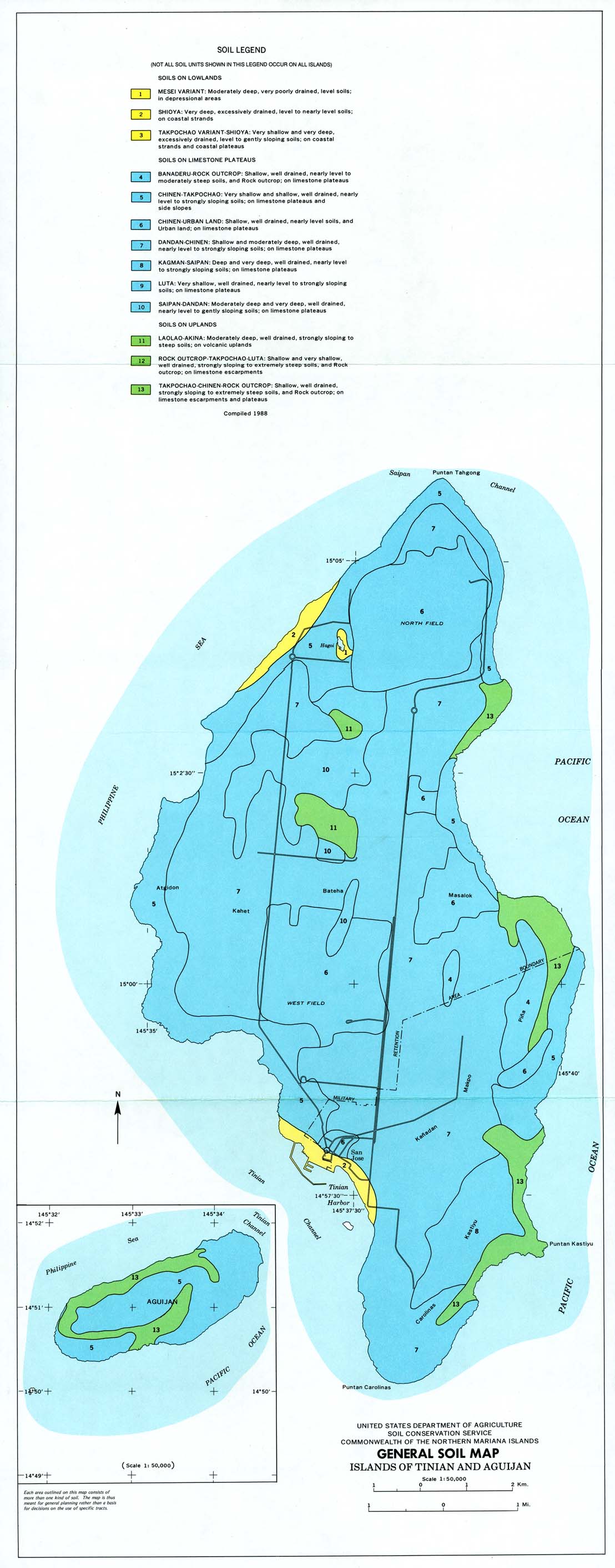
Map of soil types on the islands of Tinian and Aguijan
摘要
[編輯]
| 描述 |
English: Map of soil types on the islands of Tinian and Aguijan in the Commonwealth of the Northern Mariana Islands, as of 1988. |
| 日期 | |
| 來源 | https://maps.lib.utexas.edu/maps/australia/tinian_soil_1988.jpg |
| 作者 | United States Department of Agriculture, Soil Conservation Service |
授權條款
[編輯]
此作品在美國屬於公有領域,因為其是由美國政府的官員或僱員,基於其個人公務目的製作的作品,參考美國法典第17篇第1章第105條。
注意︰本模板僅適用於美國聯邦政府的原創作品,不適用於任何美國州、屬地、聯邦個體、縣、市或任何次級政府的作品。本模板也不適用於1978年以後由美國郵政署出版的郵票圖案(參看美國版權局實踐綱領第313.6(C)(1)條)。也不適用於部分美國硬幣;參看美國鑄幣局使用條款。 |
 | |
| 此作品無已知的著作權限制,亦不受所有相關和鄰接的權利限制。 | ||
檔案歷史
點選日期/時間以檢視該時間的檔案版本。
| 日期/時間 | 縮圖 | 尺寸 | 使用者 | 備註 | |
|---|---|---|---|---|---|
| 目前 | 2021年8月21日 (六) 00:45 | 1,108 × 2,822(288 KB) | Beland(留言 | 貢獻) | Uploaded a work by United States Department of Agriculture, Soil Conservation Service from https://maps.lib.utexas.edu/maps/australia/tinian_soil_1988.jpg with UploadWizard |
無法覆蓋此檔案。
檔案用途
沒有使用此檔案的頁面。
全域檔案使用狀況
以下其他 wiki 使用了這個檔案:
- en.wikipedia.org 的使用狀況
- zh.wikipedia.org 的使用狀況