File:Titan 2009-01 ISS polar maps.jpg
原始文件 (1,884 × 942像素,文件大小:510 KB,MIME类型:image/jpeg)
说明
说明
摘要
[编辑]| 描述 |
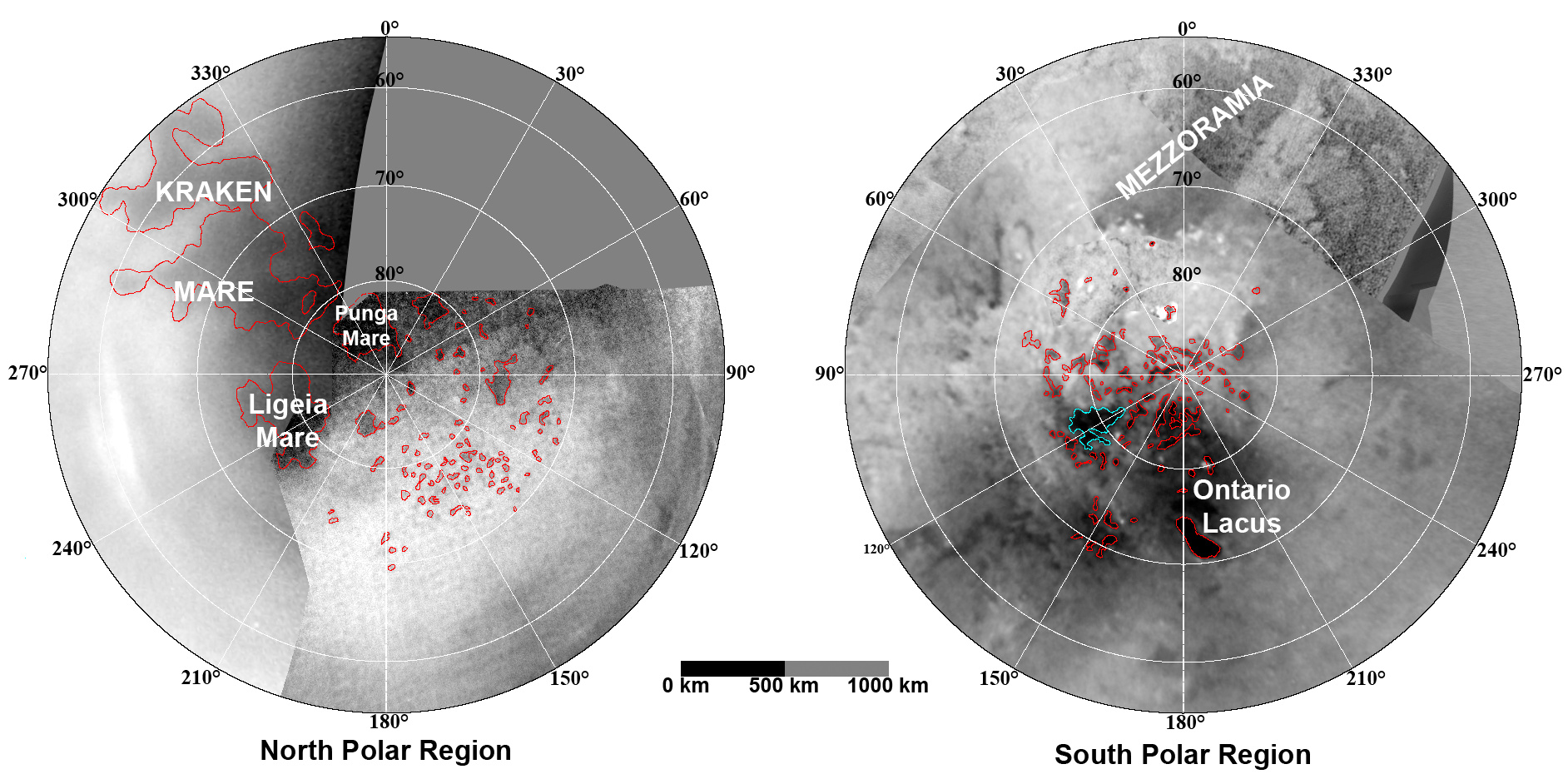
English: These updated maps of Saturn’s moon Titan, consisting of data from the Cassini Imaging Science Subsystem, include Cassini's August 2008 images of the moon's north polar region.
Evidence from Cassini's Imaging Science Subsystem, RADAR, and Visual and Infrared Mapping Spectrometer instruments strongly suggests that dark areas near the poles are lakes of liquid hydrocarbons like ethane or methane -- an analysis affirmed by images capturing changes in the lakes thought to be brought on by rainfall. Colored lines in the polar portions of these maps illustrate the boundaries between surface regions having different albedos -- or differences in surface brightness -- which Cassini scientists have interpreted as potential shorelines. Blue outlines indicate features that changed between observations made one year apart (see PIA11147). The map at left is a north polar projection showing latitudes 55 degrees to 90 degrees. The right map is a south polar projection showing latitudes minus qq55 degrees to minus 90 degrees. The maps are compiled from images dating from April 2004 through August 2008, and their resolutions vary from several hundred meters to a few tens of kilometers. Brightness variations are due to differences in surface albedo rather than topographic shading. The original NASA map of Titan has been cropped to show only the polar regions.Deutsch: Oberflächenkarte der beiden Pole, erstellt aus Daten des Cassini Imaging Science Subsystems, Januar 2009. |
| 日期 | |
| 来源 | File:TitanMapJan2009.jpg, http://photojournal.jpl.nasa.gov/catalog/PIA11146 |
| 作者 | NASA/JPL/Space Science Institute |
| 其他版本 |
http://photojournal.jpl.nasa.gov/catalog/PIA11146
|

许可协议
[编辑]
本图像属于公有领域,因该作品最初来自于美国国家海洋和大气管理局职员的职务作品。
|
文件历史
点击某个日期/时间查看对应时刻的文件。
| 日期/时间 | 缩略图 | 大小 | 用户 | 备注 | |
|---|---|---|---|---|---|
| 当前 | 2010年8月7日 (六) 23:26 | | 1,884 × 942(510 KB) | LobStoR(留言 | 贡献) | improved quality |
| 2009年1月31日 (六) 11:26 |  | 1,884 × 944(499 KB) | WolfmanSF(留言 | 贡献) | {{Information |Description={{en|1=These updated maps of Saturn’s moon Titan, consisting of data from the Cassini Imaging Science Subsystem, include Cassini's August 2008 images of the moon's north polar region. Evidence from Cassini's Imaging Science S |
您不可以覆盖此文件。
文件用途
没有页面使用本文件。
全域文件用途
以下其他wiki使用此文件:
- an.wikipedia.org上的用途
- ar.wikipedia.org上的用途
- be.wikipedia.org上的用途
- de.wikipedia.org上的用途
- en.wikipedia.org上的用途
- en.wikiversity.org上的用途
- fr.wikipedia.org上的用途
- hy.wikipedia.org上的用途
- id.wikipedia.org上的用途
- ja.wikipedia.org上的用途
- lb.wikipedia.org上的用途
- mk.wikipedia.org上的用途
- no.wikipedia.org上的用途
- ro.wikipedia.org上的用途
- ru.wikipedia.org上的用途
- uk.wikipedia.org上的用途
- vi.wikipedia.org上的用途
- zh.wikipedia.org上的用途