File:Tondo and Pasig 1450.png

原始檔案 (1,778 × 1,699 像素,檔案大小:90 KB,MIME 類型:image/png)
說明
說明
摘要
[編輯]
| 描述 |
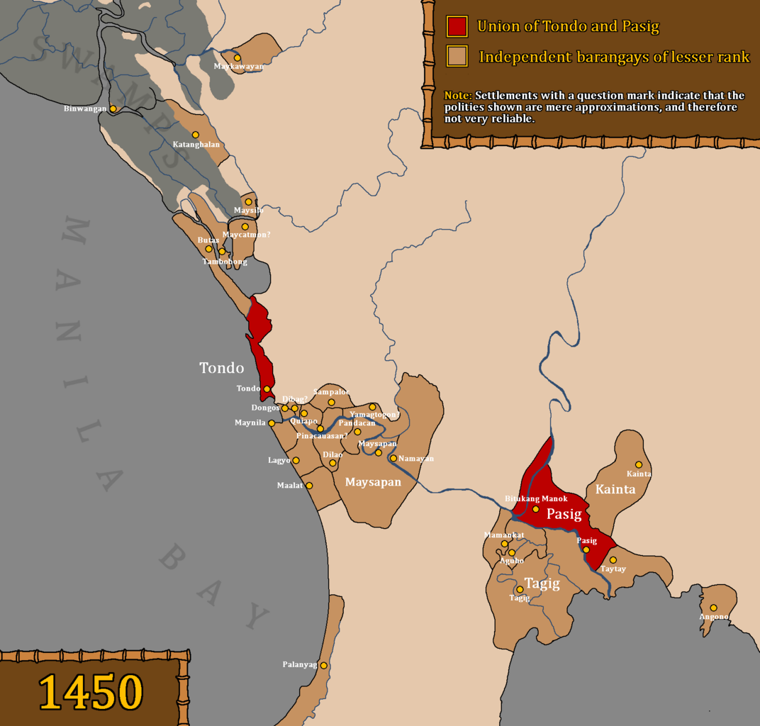
Map of the Union of Tondo and Pasig, also referred to as the Kingdom of Tondo, as well as other influenced barangays during the rule of Dayang Kalangitan in 約1450. This map uses question marks for places whose locations are deemed uncertain and not fully reliable. Interpretations based on "Estado, Topográfico, Estadistíco, Histórico—Religioso, de la Santa y Apostólica Provincia de San Gregorio Magno, de Religiosos Menores Descalzos de la Regular y Mas Estrecha Observancia De Nuestro Padre San Francisco, en las Islas Filipinas" by Fr. Felix Huerta Places like Meycatmon, Dibag, Pinacauasan, and Yamagtogon have uncertain locations, but are placed with approximate locations because Fr. Felix Huerta seems to have arranged the settlements in the right order, from Meycatmon "hasta" (until) Meysapan (Santa Ana). So, from Meycatmon all the way to Meysapan. Meycatmon (potentially the barangay of Catmon north of Tondo), Calatondongan (Tondo/Tondong/Tundun), Dongos (Santo Cristo de Longos, modern-day Binondo and San Nicolas), Dibag, Pinacauasan, Yamagtogon until Meysapan. Santa Cruz, San Miguel, and Santa Mesa do not have precolonial names preserved, despite having proof that it was inhabited prior to Spanish colonization. Therefore, in the area from Santa Cruz to Santa Mesa are the likely locations of Dibag, Pinacauasan and Yamagtogon, in a left-to-right order. Another thing that the author wants to clarify is that Namayan was a confederation and not a single entity, and as stated in Fr. Felix Huerta's work, ruled by a "petty king" named Lakan Tagkan. While the confederation was most likely headed by Namayan by 1570, this did not mean that they had direct control over other barangays. Also, there is no proof that Namayan held some degree of control over the mentioned territories in Fr. Felix Huerta's document before Lakan Tagkan. Furthermore, the excavations of old Chinese goods and piloncitos found in Santa Ana as stated in the Namayan Wikipedia page are not an indicator of Namayan's territories and influence. It was simply a proof of economic relations with the states around them. Furthermore, if we make logical estimates as to when Lakan Tagkan may have possibly ruled, based on genealogical records and the potential lifespan of people at the time, Lakan Tagkan may have only ruled in the mid to late 1400s. Lakan Tagkan is the great grandfather of Calamayin, who ruled during the 1570s. Fr. Felix Huerta also mentions that the "origins of the naturales of these territories" came from the kingdom established by Lakan Tagkan, so it is certain that Namayan only started dominating under Lakan Tagkan. Pasay was not included as it was a newly established settlement only during the reign of Lakan Tagkan, and this map precedes the reign of Lakan Tagkan of Namayan. There is also no proof that Namayan and Meysapan are the same entity. Fr. Felix Huerta has made it clear that Namayan was merely absorbed into Santa Ana de Sapa into a barrio (village) during the Spanish era. He did not mention that Meysapan was the seat of power, but Namayan. He further stated that Meysapan was only a territory of Namayan, never mentioning that Meysapan was ever Namayan. This was an indication that Meysapan (Sapa) and Namayan were two different settlements. Therefore, Namayan (in Mandaluyong) was the capital of Namayan, not Santa Ana de Sapa. Santa Ana was only made the seat of power of large swathes of areas during the Spanish era. It is very possible but not certain that Fr. Felix Huerta misinterpreted the barangays within the confederation headed by Namayan as Namayan's "territories", as no older Spanish accounts prior to Felix Huerta's work in the 19th century seem to mention various places all as part of one centralized kingdom known as Namayan. Furthermore, places like Pandacan, Taguig, Catanghalan, Maysilo/Misil, Polo, Tambobong, Navotas, and other areas clearly had their own local datus, hence they were able to take part in the Tondo Conspiracy of 1587. Binwangan (Binwangan, Obando) was also mentioned in the Laguna Copperplate Inscription. It is also not unlikely for Tondo to be absorbed into the confederation headed by Namayan under Lakan Tagkan. As stated by Nick Joaquin, that Tondo had "replaced Namayan as the chief port of entry on Manila Bay", indicating that Tondo may have only recently became increasingly less dependent and eventually became independent from Namayan. Fr. Felix Huerta made mention of Pandacan as part of Namayan, but as stated before, and according to older Spanish sources, this place had its own local datu. The Spaniards as well as Chinese records have a history of simplifying this confederation system in Luzon, insofar as simplifying them as the "Kingdom of Tondo" (Spanish records) or the "Kingdom of Lusung" (History of Ming). It is the best option to take account of these clear biases when portraying or discussing the system of governance in the pre-colonial Tagalog region. |
| 日期 | |
| 來源 |
Original work by DeliriumMaps (Delirium333). The information was gathered from the following sources: Wikipedia Sources
Other Sources
|
| 作者 | Delirium333 |
授權條款
[編輯]

|
已授權您依據自由軟體基金會發行的無固定段落、封面文字和封底文字GNU自由文件授權條款1.2版或任意後續版本,對本檔進行複製、傳播和/或修改。該協議的副本列在GNU自由文件授權條款中。 |
- 您可以自由:
- 分享 – 複製、發佈和傳播本作品
- 重新修改 – 創作演繹作品
- 惟需遵照下列條件:
- 姓名標示 – 您必須指名出正確的製作者,和提供授權條款的連結,以及表示是否有對內容上做出變更。您可以用任何合理的方式來行動,但不得以任何方式表明授權條款是對您許可或是由您所使用。
- 相同方式分享 – 如果您利用本素材進行再混合、轉換或創作,您必須基於如同原先的相同或兼容的條款,來分布您的貢獻成品。
檔案歷史
點選日期/時間以檢視該時間的檔案版本。
| 日期/時間 | 縮圖 | 尺寸 | 用戶 | 備註 | |
|---|---|---|---|---|---|
| 目前 | 2024年4月14日 (日) 02:09 | | 1,778 × 1,699(90 KB) | Delirium333(對話 | 貢獻) | the swamps were bigger than initially portrayed |
| 2024年4月12日 (五) 09:07 |  | 1,778 × 1,699(89 KB) | Delirium333(對話 | 貢獻) | removed polo as it most likely wasnt a precolonial settlement and theres no evidence for it so im removing it | |
| 2024年4月10日 (三) 21:25 |  | 1,778 × 1,699(90 KB) | Delirium333(對話 | 貢獻) | clarified the distinction of waters and swamps | |
| 2024年4月9日 (二) 09:59 |  | 1,778 × 1,699(82 KB) | Delirium333(對話 | 貢獻) | added mamancat and aguho, expanded the territorial scope of maysapan, additional sources were also added in the desc | |
| 2024年4月8日 (一) 13:32 |  | 1,778 × 1,699(79 KB) | Delirium333(對話 | 貢獻) | added lagyo | |
| 2024年4月8日 (一) 13:08 |  | 1,778 × 1,699(79 KB) | Delirium333(對話 | 貢獻) | slight modification of the pasig river, this is purely cosmetic and the difference is only by mere pixels | |
| 2024年4月8日 (一) 13:06 |  | 1,778 × 1,699(79 KB) | Delirium333(對話 | 貢獻) | mainly a change of color choice to avoid misconceptions | |
| 2023年9月18日 (一) 13:48 |  | 1,778 × 1,699(78 KB) | Delirium333(對話 | 貢獻) | made cosmetic changes, cuz i accidentally painted a tiny pixel area with the wrong color, i want my map looking professional and clean | |
| 2023年9月18日 (一) 11:53 |  | 1,778 × 1,699(78 KB) | Delirium333(對話 | 貢獻) | fixed a lot of mistakes after rereading fr. felix huerta's document. one major mistake was including taguig as part of namayan when it was not. also there was no proof namayan held large territories before lakan tagkan. and lakan tagkan if we make geneaological estimates was most likely the ruler of namayan only in the mid to late 1400s | |
| 2023年9月16日 (六) 15:28 |  | 1,778 × 1,699(150 KB) | Delirium333(對話 | 貢獻) | modified the border of dongos and tondo |
無法覆蓋此檔案。
檔案用途
下列頁面有用到此檔案:
- File:Tondonamayan1450.png (檔案重新導向)
全域檔案使用狀況
以下其他 wiki 使用了這個檔案:
- en.wikipedia.org 的使用狀況
- es.wikipedia.org 的使用狀況
- it.wikipedia.org 的使用狀況
- ko.wikipedia.org 的使用狀況
- pt.wikipedia.org 的使用狀況
- ru.wikipedia.org 的使用狀況
- sr.wikipedia.org 的使用狀況
- tl.wikipedia.org 的使用狀況
- zh.wikipedia.org 的使用狀況