File:Tooelecounty.png
Zur Navigation springen
Zur Suche springen

Größe dieser Vorschau: 742 × 599 Pixel. Weitere Auflösungen: 297 × 240 Pixel | 594 × 480 Pixel | 951 × 768 Pixel | 1.024 × 827 Pixel.
Originaldatei (1.024 × 827 Pixel, Dateigröße: 149 KB, MIME-Typ: image/png)
Bildtexte
Kurzbeschreibungen
Ergänze eine einzeilige Erklärung, was diese Datei darstellt.
Beschreibung[Bearbeiten]
| Beschreibung |
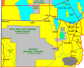
Tooele County , selfmade graphic by R.Blauert Dk4hb |
| Datum | 29. Januar 2006 (Original-Hochladedatum) |
| Quelle | Die Autorenschaft wurde nicht in einer maschinell lesbaren Form angegeben. Es wird angenommen, dass es sich um ein eigenes Werk handelt (basierend auf den Rechteinhaber-Angaben). |
| Urheber | Die Autorenschaft wurde nicht in einer maschinell lesbaren Form angegeben. Es wird Dk4hb~commonswiki als Autor angenommen (basierend auf den Rechteinhaber-Angaben). |
Lizenz[Bearbeiten]
| Dieses Werk wurde von seinem Urheber I, Dk4hb als gemeinfrei veröffentlicht. Dies gilt weltweit. In manchen Staaten könnte dies rechtlich nicht möglich sein. Sofern dies der Fall ist: I, Dk4hb gewährt jedem das bedingungslose Recht, dieses Werk für jedweden Zweck zu nutzen, es sei denn, Bedingungen sind gesetzlich erforderlich. |
Dateiversionen
Klicke auf einen Zeitpunkt, um diese Version zu laden.
| Version vom | Vorschaubild | Maße | Benutzer | Kommentar | |
|---|---|---|---|---|---|
| aktuell | 19:40, 29. Jan. 2006 | | 1.024 × 827 (149 KB) | Dk4hb~commonswiki (Diskussion | Beiträge) | Tooele County , selfmade graphic by R.Blauert(dk4hb) |
Du kannst diese Datei nicht überschreiben.
Dateiverwendung
Keine Seiten verwenden diese Datei.
Globale Dateiverwendung
Die nachfolgenden anderen Wikis verwenden diese Datei:
- Verwendung auf de.wikipedia.org
- Verwendung auf ja.wikipedia.org
- Verwendung auf la.wikipedia.org
Kategorien:
- Maps of Tooele County, Utah
- Great Salt Lake Desert
- Dugway Proving Ground
- Utah Test and Training Range
- Maps of the Great Salt Lake
- Maps of Dugway, Utah
- Salt Springs, Utah
- Ibapah, Utah
- Gold Hill, Utah
- Wendover, Utah
- Knolls, Utah
- Argonite, Utah
- Low, Utah
- Delle, Utah
- Faust, Utah
- Vernon, Utah
- Buildings in Tooele, Utah
- Bauer, Utah
- Stockton, Utah
- Maps of Ophir, Utah
- Maps of Mercur, Utah
- Erda, Utah
- Grantsville, Utah
- Burmester, Utah
- Iosepa, Utah
- Rush Valley, Utah
- Stansbury Island
- Carrinton Island