File:Topographic View of Ceres Mountain - PIA19976.jpg

原始文件 (1,858 × 514像素,文件大小:107 KB,MIME类型:image/jpeg)
说明
说明
摘要
[编辑]
| 描述 |
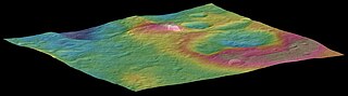
English: This view, made using images taken by NASA's Dawn spacecraft, features a tall conical mountain on Ceres.
Elevations span a range of about 5 miles (8 kilometers) from the lowest places in this region to the highest terrains. Blue represents the lowest elevation, and brown is the highest. The white streaks seen running down the side of the mountain are especially bright parts of the surface. The image was generated using two components: images of the surface taken during Dawn's High Altitude Mapping Orbit (HAMO) phase, where it viewed the surface at a resolution of about 450 feet (140 meters) per pixel, and a shape model generated using images taken at varying sun and viewing angles during Dawn's lower-resolution Survey phase. The image of the region is color-coded according to elevation, and then draped over the shape model to give this view. Dawn's mission is managed by JPL for NASA's Science Mission Directorate in Washington. Dawn is a project of the directorate's Discovery Program, managed by NASA's Marshall Space Flight Center in Huntsville, Alabama. UCLA is responsible for overall Dawn mission science. Orbital ATK, Inc., in Dulles, Virginia, designed and built the spacecraft. The German Aerospace Center, the Max Planck Institute for Solar System Research, the Italian Space Agency and the Italian National Astrophysical Institute are international partners on the mission team. For a complete list of acknowledgments, see http://dawn.jpl.nasa.gov/mission. For more information about the Dawn mission, visit http://dawn.jpl.nasa.gov. |
| 日期 | |
| 来源 | http://photojournal.jpl.nasa.gov/catalog/PIA19976 |
| 作者 | NASA / JPL-Caltech / UCLA / MPS / DLR / IDA / PSI |
许可协议
[编辑]
| 本文件完全由NASA创作,在美国属于公有领域。根据NASA的版权方针,NASA的材料除非另有声明否则不受版权保护。(参见Template:PD-USGov/zh、NASA版权方针页面或JPL图片使用方针。) | ||
 |
警告:
|
文件历史
点击某个日期/时间查看对应时刻的文件。
| 日期/时间 | 缩略图 | 大小 | 用户 | 备注 | |
|---|---|---|---|---|---|
| 当前 | 2015年10月1日 (四) 13:20 | 1,858 × 514(107 KB) | Drbogdan(留言 | 贡献) | cropped (via JASC Paint Shop Pro v6.02) - seems better | |
| 2015年10月1日 (四) 03:34 |  | 1,920 × 1,080(99 KB) | WolfmanSF(留言 | 贡献) | User created page with UploadWizard |
您不可以覆盖此文件。
文件用途
以下页面使用本文件:
- File:PIA19976.jpg(文件重定向)
全域文件用途
以下其他wiki使用此文件:
- fr.wikipedia.org上的用途
- zh.wikipedia.org上的用途