File:Topographische Bildkarte des Ostens von Noctis Labyrinthus (53484622663).jpg
Перейти к навигации
Перейти к поиску

Размер этого предпросмотра: 371 × 598 пкс. Другие разрешения: 149 × 240 пкс | 297 × 480 пкс | 476 × 768 пкс | 635 × 1024 пкс | 1269 × 2048 пкс | 6000 × 9679 пкс.
Исходный файл (6000 × 9679 пкс, размер файла: 9,01 МБ, MIME-тип: image/jpeg)
Краткие подписи
Краткие подписи
Добавьте однострочное описание того, что собой представляет этот файл
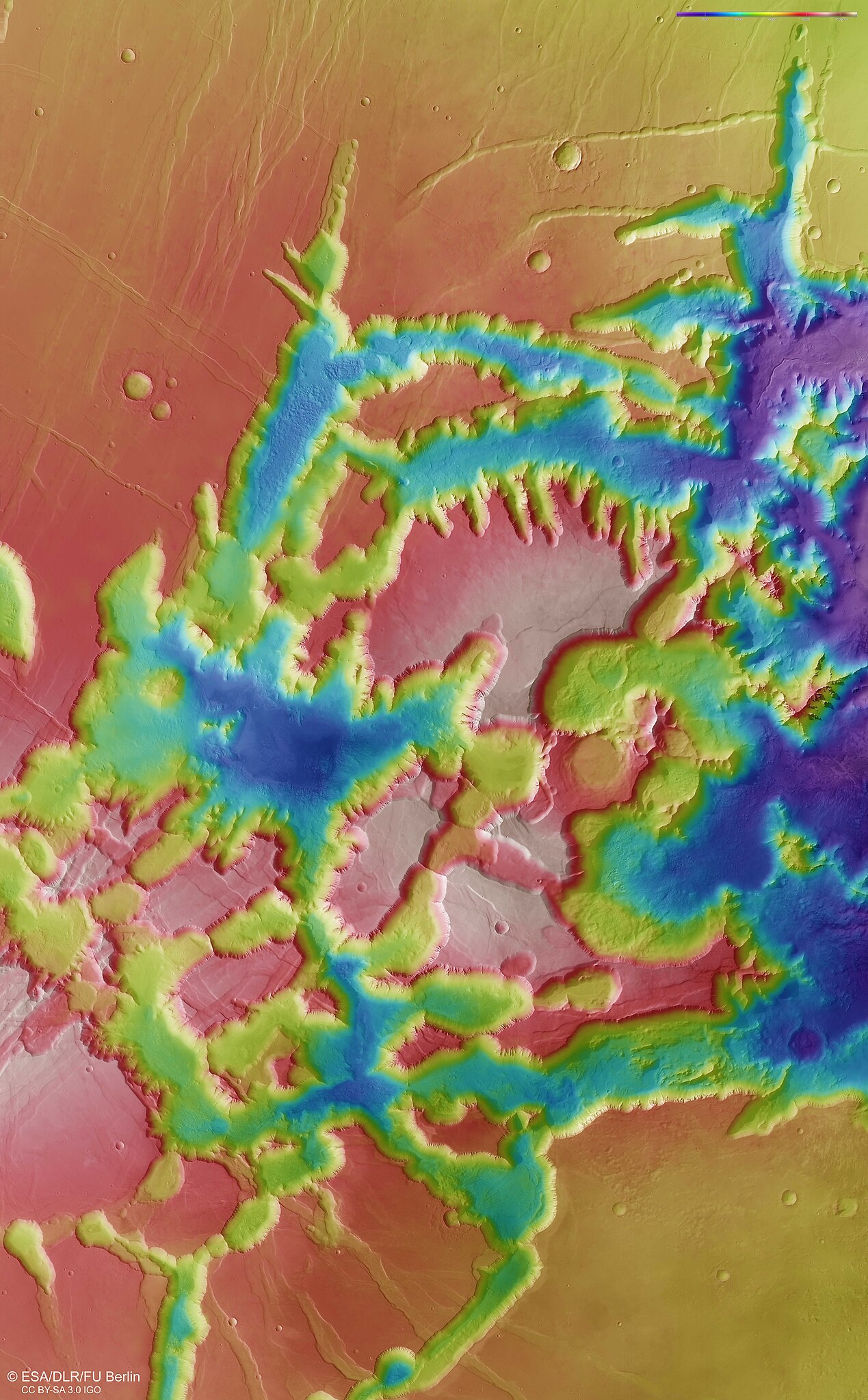
The DLR stereo camera HRSC on Mars Express uses nine sensors to record the surface of Mars from different angles.
Краткое описание
[править].jpg&action=edit§ion=1)
| Описание |
Deutsch: Die DLR-Stereokamera HRSC auf Mars Express nimmt mit ihren neun Sensoren die Marsoberfläche unter verschiedenen Blickwinkeln auf. Aus je zwei schräg nach vorne und nach hinten auf die Oberfläche gerichteten Stereokanälen und dem senkrecht auf den Mars gerichteten Nadirkanal berechnen Wissenschaftlerteams am DLR-Institut für Planetenforschung und der Freien Universität Berlin digitale Geländemodelle, die jedem Bildpunkt eine Höheninformation zuordnen. An der Farbskala rechts oben im Bild lassen sich die Höhenwerte ablesen, bezogen auf das Areoid, eine gedachte Oberfläche auf dem Mars mit gleicher Anziehungskraft. Dadurch lassen sich gut die spektakulären Dimensionen dieser Region darstellen. Die tektonischen Brüche haben 4.000 bis 5.000 Meter tiefe Täler im südlichen Marshochland entstehen lassen.
Bild: 3/7, Credit: ESA/DLR/FU Berlin (CC BY-SA 3.0 IGO) English: The DLR stereo camera HRSC on Mars Express uses nine sensors to record the surface of Mars from different angles. Teams of scientists at the DLR Institute for Planetary Research and the Free University of Berlin use two stereo channels directed obliquely forward and backward onto the surface and the nadir channel directed vertically towards Mars to calculate digital terrain models that assign height information to each image point. The height values can be read from the color scale at the top right of the image, based on the areoid, an imaginary surface on Mars with the same gravitational pull. This makes it easy to show the spectacular dimensions of this region. The tectonic fractures have created valleys 4,000 to 5,000 meters deep in the southern Martian highlands. Image: 3/7, Credit: ESA/DLR/FU Berlin (CC BY-SA 3.0 IGO) |
| Дата | Снято: 22 января 2024, 14:13:17 |
| Источник | Topographische Bildkarte des Ostens von Noctis Labyrinthus |
| Автор | DLR_de |
| Flickr set | Mars Express |
| Flickr tags | marsexpress; mars |
Лицензирование
[править].jpg&action=edit§ion=2)
Этот файл доступен по лицензии Creative Commons Attribution-Share Alike 2.0 Generic
- Вы можете свободно:
- делиться произведением – копировать, распространять и передавать данное произведение
- создавать производные – переделывать данное произведение
- При соблюдении следующих условий:
- атрибуция – Вы должны указать авторство, предоставить ссылку на лицензию и указать, внёс ли автор какие-либо изменения. Это можно сделать любым разумным способом, но не создавая впечатление, что лицензиат поддерживает вас или использование вами данного произведения.
- распространение на тех же условиях – Если вы изменяете, преобразуете или создаёте иное произведение на основе данного, то обязаны использовать лицензию исходного произведения или лицензию, совместимую с исходной.
| Это изображение изначально опубликовано на Flickr участником проекта DLR_de по ссылке https://flickr.com/photos/48213136@N06/53484622663. Оно было досмотрено 25 января 2024 роботом FlickreviewR 2, который подтвердил, что изображение лицензировано в соответствии с условиями cc-by-sa-2.0. |
| This media has been released under a free license by the Deutsches Zentrum für Luft- und Raumfahrt (DLR). Their website states: "Where expressly stated, DLR images and videos are covered by a Creative Commons Attribution 3.0 Germany (CC BY 3.0) licence. This licence grants permission to reproduce or distribute the work, to make the work and/or its contents publically available, to alter or edit the work and/or its contents and to make commercial use of the work, provided that you explicitly mention DLR as its source in a clearly legible format. Examples: 'Photo: DLR, CC-BY 3.0', 'Images: DLR, CC-BY 3.0', 'Video: DLR, CC-BY 3.0'." To the uploader: You must provide a link (URL) to the original file and the authorship information if available. |
Этот файл доступен по лицензии Creative Commons Attribution 3.0 Германия.
Атрибуция: DLR, CC-BY 3.0
- Вы можете свободно:
- делиться произведением – копировать, распространять и передавать данное произведение
- создавать производные – переделывать данное произведение
- При соблюдении следующих условий:
- атрибуция – Вы должны указать авторство, предоставить ссылку на лицензию и указать, внёс ли автор какие-либо изменения. Это можно сделать любым разумным способом, но не создавая впечатление, что лицензиат поддерживает вас или использование вами данного произведения.

This media was created by the European Space Agency (ESA).
Where expressly so stated, images or videos are covered by the Creative Commons Attribution-ShareAlike 3.0 IGO (CC BY-SA 3.0 IGO) licence, ESA being an Intergovernmental Organisation (IGO), as defined by the CC BY-SA 3.0 IGO licence. The user is allowed under the terms and conditions of the CC BY-SA 3.0 IGO license to Reproduce, Distribute and Publicly Perform the ESA images and videos released under CC BY-SA 3.0 IGO licence and the Adaptations thereof, without further explicit permission being necessary, for as long as the user complies with the conditions and restrictions set forth in the CC BY-SA 3.0 IGO licence, these including that:
See the ESA Creative Commons copyright notice for complete information, and this article for additional details.
|
 | |
Этот файл доступен по лицензии Creative Commons Attribution-Share Alike 3.0 IGO. Атрибуция: ESA/DLR/FU Berlin, CC BY-SA IGO 3.0
| ||
История файла
Нажмите на дату/время, чтобы увидеть версию файла от того времени.
| Дата/время | Миниатюра | Размеры | Участник | Примечание | |
|---|---|---|---|---|---|
| текущий | 00:06, 25 января 2024 | | 6000 × 9679 (9,01 МБ) | OptimusPrimeBot (обсуждение | вклад) | #Spacemedia - Upload of https://live.staticflickr.com/65535/53484622663_485cbe2995_o.jpg via Commons:Spacemedia |
Вы не можете перезаписать этот файл.
Использование файла
Следующая страница использует этот файл:
.jpg&oldid=909715787)