File:Tram map of Zwickau.xcf

元のファイル (990 × 971 ピクセル、ファイルサイズ: 1.49メガバイト、MIME タイプ: image/x-xcf)
キャプション
キャプション
|
|
概要
[編集]| 記述 |
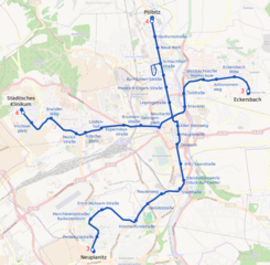
English: Tramway network of Zwickau, Germany Deutsch: Topographischer Netzplan der Straßenbahn Zwickau |
|||
| 日付 | ||||
| 原典 | openstreetmap.org | |||
| 作者 |
OpenStreetMapへの協力者 |
|||
| 許可 (ファイルの再利用) |
オープンストリートマップのデータは、 Open Database License(オープン・データ・ライセンス) (詳細)の下に利用可能です。地図のタイトルは、クリエイティブ・コモンズ 表示 - 継承 2.0 (CC-BY-SA 2.0) によりライセンスされています。
このファイルはクリエイティブ・コモンズ 表示-継承 2.0 一般ライセンスのもとに利用を許諾されています。
|
|||
| Georeferencing | If inappropriate please set warp_status = skip to hide. |
ファイルの履歴
過去の版のファイルを表示するには、その版の日時をクリックしてください。
| 日付と時刻 | サムネイル | 寸法 | 利用者 | コメント | |
|---|---|---|---|---|---|
| 現在の版 | 2019年12月21日 (土) 21:43 |  | 990 × 971 (1.49メガバイト) | Bürgerentscheid (トーク | 投稿記録) | updated to 2019-12-14 |
| 2013年4月18日 (木) 08:47 |  | 990 × 971 (1.63メガバイト) | Bürgerentscheid (トーク | 投稿記録) | {{XCF}} == {{int:filedesc}} == {{Information |Description=Tramway network of Zwickau |Date=2013-04-18 |Author= ~~~ |Source= Openstreetmap |Permission= |other_versions=thumb|left|Correctly rendered PNG-versioin }} [[Cat... |
このファイルは上書きできません。
ファイルの使用状況
以下の 4 ページがこのファイルを使用しています:
グローバルなファイル使用状況
以下に挙げる他のウィキがこの画像を使っています:
- de.wikipedia.org での使用状況
- de.wikivoyage.org での使用状況
- en.wikipedia.org での使用状況
- en.wikivoyage.org での使用状況
- eo.wikipedia.org での使用状況
- fa.wikipedia.org での使用状況
- fr.wikipedia.org での使用状況
- it.wikipedia.org での使用状況
- ja.wikipedia.org での使用状況
- nl.wikipedia.org での使用状況
- pl.wikivoyage.org での使用状況