File:Transsib international.svg
跳至導覽
跳至搜尋

此 SVG 檔案的 PNG 預覽的大小:800 × 566 像素。 其他解析度:320 × 226 像素 | 640 × 453 像素 | 1,024 × 724 像素 | 1,280 × 905 像素 | 2,560 × 1,811 像素 | 2,293 × 1,622 像素。
原始檔案 (SVG 檔案,表面大小:2,293 × 1,622 像素,檔案大小:1.38 MB)
說明
說明
添加單行說明來描述出檔案所代表的內容
摘要
[編輯]| 描述 |
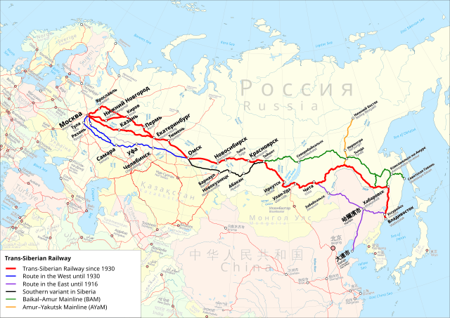
Deutsch: Karte der Transsibirische Eisenbahn. Rot: Streckenführung der Transsibirische Eisenbahn ab 1930. Blau: Streckenführung im Westen vor 1930. Violett: Streckenführung im Osten bis 1916. Schwarz: Südvariante in Sibirien. Grün: Baikal–Amur-Magistrale. Orange: Amur—Yakutsk-Magistrale. Internationale Version mit Namen in der Landessprache und englischer Übersetzung. English: Trans-Siberian Railroad map. Red: Route of the Trans-Siberian Railway since 1930. Blue: Route in the west before 1930. Violet: Route in the east until 1916. Black: Southern variant in Siberia. Green: Baikal–Amur Mainline. Orange: Amur–Yakutsk Mainline. International Version with Names in local language and English translation.
Equidistant conic projection: Central meridian : * E: 100.0° E Standard parallels: * 1: 49.0° N * 2: 59.0° N Projection Code used for QGIS: * +proj=eqdc +lon_0=100e +lat_l=49n +lat_2=59n |
| 日期 | |
| 來源 |
Map was created using:
|
| 作者 |
|
| 授權許可 (重用此檔案) |
|
| 其他版本 |
|


| This work is licensed under the Open Database License (summary). |
檔案歷史
點選日期/時間以檢視該時間的檔案版本。
| 日期/時間 | 縮圖 | 尺寸 | 用戶 | 備註 | |
|---|---|---|---|---|---|
| 目前 | 2021年8月11日 (三) 06:07 | | 2,293 × 1,622(1.38 MB) | Pzgulyas(對話 | 貢獻) | i18n-ed legend |
| 2021年8月10日 (二) 13:20 |  | 2,293 × 1,622(1.37 MB) | Pzgulyas(對話 | 貢獻) | Removed duplicate texts in legends | |
| 2020年3月17日 (二) 19:45 |  | 2,293 × 1,622(1.38 MB) | Pechristener(對話 | 貢獻) | more fixes | |
| 2020年3月17日 (二) 19:38 |  | 2,293 × 1,622(1.38 MB) | Pechristener(對話 | 貢獻) | Some rendering issues with Internet Explorer fixed, other small corrections | |
| 2020年3月14日 (六) 16:56 |  | 2,293 × 1,622(1.36 MB) | Pechristener(對話 | 貢獻) | some small fixes | |
| 2020年3月14日 (六) 13:27 |  | 2,293 × 1,622(1.35 MB) | Pechristener(對話 | 貢獻) | ergänzt gemäss Disk KW | |
| 2019年11月16日 (六) 12:15 |  | 2,293 × 1,622(1.26 MB) | Pechristener(對話 | 貢獻) | wrong file uploaded / wrong description edited | |
| 2019年11月16日 (六) 12:13 |  | 2,293 × 1,622(772 KB) | Pechristener(對話 | 貢獻) | == {{int:filedesc}} == {{Information |description={{de|Karte der Transsibirische Eisenbahn. Rot: Streckenführung der Transsibirische Eisenbahn ab 1930. Blau: Streckenführung im Westen vor 1930. Violett: Streckenführung im Osten bis 1916. Schwarz: Südvariante in Sibirien. Grün: Baikal–Amur-Magistrale. Orange: Amur—Yakutsk-Magistrale. Version ohne Städte- und Ländernamen für Übersetzungen in andere Sprachen.}}{{en|Trans-Siberian Railroad map. Red: Route of the Trans-Siberian Railway since 1930.... | |
| 2019年11月16日 (六) 08:25 |  | 2,293 × 1,622(1.26 MB) | Pechristener(對話 | 貢獻) | == {{int:filedesc}} == {{Information |description={{de|Karte der Transsibirische Eisenbahn. Rot: Streckenführung der Transsibirische Eisenbahn ab 1930. Blau: Streckenführung im Westen vor 1930. Violett: Streckenführung im Osten bis 1916. Schwarz: Südvariante in Sibirien. Grün: Baikal–Amur-Magistrale. Orange: Amur—Yakutsk-Magistrale. Internationale Version mit Namen in der Landessprache und englischer Übersetzung.}}{{en|Trans-Siberian Railroad map. Red: Route of the Trans-Siberian Railway sinc... |
無法覆蓋此檔案。
檔案用途
下列12個頁面有用到此檔案:
- Транссибирская магистраль
- User:Chumwa/OgreBot/Potential transport maps/2019 November 11-20
- User:Chumwa/OgreBot/Public transport information/2019 November 11-20
- User:Chumwa/OgreBot/Public transport information/2020 March 11-20
- User:Chumwa/OgreBot/Public transport information/2021 August 11-20
- User:Chumwa/OgreBot/Transport Maps/2019 November 11-20
- User:Chumwa/OgreBot/Transport Maps/2020 March 11-20
- User:Chumwa/OgreBot/Transport Maps/2021 August 11-20
- File:Ayam-route-map.png
- File:Karte Transsibirische Eisenbahn 2.svg
- File:Map Trans-Siberian railway.png
- File:Transsib no names.svg
全域檔案使用狀況
以下其他 wiki 使用了這個檔案:
- ckb.wikipedia.org 的使用狀況
- de.wikipedia.org 的使用狀況
- en.wikipedia.org 的使用狀況
- fa.wikipedia.org 的使用狀況
- he.wikivoyage.org 的使用狀況
- hi.wikibooks.org 的使用狀況
- ko.wikipedia.org 的使用狀況
- lv.wikipedia.org 的使用狀況
- pl.wikipedia.org 的使用狀況
- th.wikipedia.org 的使用狀況
- zh.wikipedia.org 的使用狀況