File:Trebizond1400.png
跳至導覽
跳至搜尋
無更高解析度可提供。
Trebizond1400.png (635 × 401 像素,檔案大小:107 KB,MIME 類型:image/png)
說明
說明
添加單行說明來描述出檔案所代表的內容
摘要[編輯]
| 描述 |
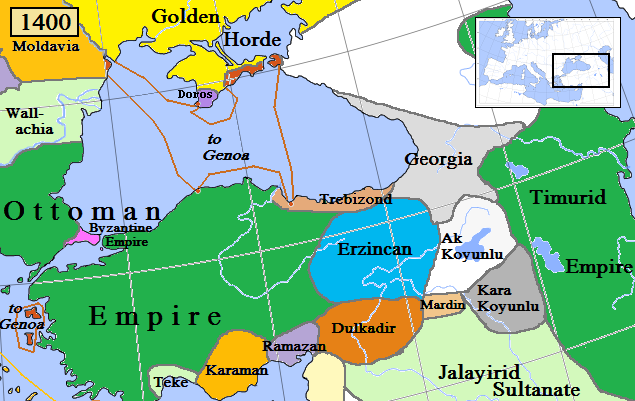
English: Trebizond and surrounding states in Anatolia/Caucasus in AD 1400.
(Partially based on Euratlas map of Europe, 1400, improved since Koza Yayınları Tarih Atlası sf.42; Kanaat Yayınları Tarih Atlası sf.28; Mutafian, Claude & Van Lauwe, Eric: Atlas historique de l'Arménie, Autrement publ., coll. «Atlas/Memoires», Paris 2001, ISBN 2-7467-0100-6 and since the graphic style of [1]) |
| 日期 | |
| 來源 | 自己的作品 |
| 作者 | Gabagool |
![[1]](http://vignette3.wikia.nocookie.net/genealogy/images/c/cf/Trebizond1300.png/revision/latest/thumbnail-down/width/340/height/340?cb=20110516182142)

|
本圖片是以PNG、GIF或JPEG格式上傳。然而,其中包含的資料或訊息,應該重新建立成可縮放向量圖形(SVG)檔案,以更有效率或更準確的方式儲存。如有可能,請上傳本圖片的SVG格式版本。在上傳之後,請修改維基各姊妹計畫中所有使用舊版圖片的條目(列在圖像連結章節中),替換為新版圖片,並在舊圖片的描述頁中加入{{Vector version available|新圖片名稱.svg}}模板,同時移除本模板。
|
授權條款[編輯]
我,本作品的著作權持有者,決定用以下授權條款發佈本作品:
此檔案採用創用CC 姓名標示 3.0 未在地化版本授權條款。
- 您可以自由:
- 分享 – 複製、發佈和傳播本作品
- 重新修改 – 創作演繹作品
- 惟需遵照下列條件:
- 姓名標示 – 您必須指名出正確的製作者,和提供授權條款的連結,以及表示是否有對內容上做出變更。您可以用任何合理的方式來行動,但不得以任何方式表明授權條款是對您許可或是由您所使用。
檔案歷史
點選日期/時間以檢視該時間的檔案版本。
| 日期/時間 | 縮圖 | 尺寸 | 用戶 | 備註 | |
|---|---|---|---|---|---|
| 目前 | 2018年4月6日 (五) 11:03 | | 635 × 401(107 KB) | Trecătorul răcit(對話 | 貢獻) | Little changes since ''Koza Yayınları Tarih Atlası'' sf.42; ''Kanaat Yayınları Tarih Atlası'' sf.28; Mutafian, Claude & Van Lauwe, Eric: ''Atlas historique de l'Arménie'', Autrement publ., coll. «Atlas/Memoires», Paris 2001, ISBN 2-7467-0100-6 and since the graphic style of [http://vignette3.wikia.nocookie.net/genealogy/images/c/cf/Trebizond1300.png/revision/latest/thumbnail-down/width/340/height/340?cb=20110516182142] |
| 2009年4月17日 (五) 22:45 |  | 635 × 401(82 KB) | Gabagool(對話 | 貢獻) | {{Information |Description={{en|1=Trebizond and surrounding states in Anatolia/Caucasus in AD 1400. (Partially based on Euratlas map of Europe, 1400.)}} |Source=Own work by uploader |Author=Gabagool |Date=2009-04-18 |Permission= |other_ |
無法覆蓋此檔案。
檔案用途
沒有使用此檔案的頁面。
全域檔案使用狀況
以下其他 wiki 使用了這個檔案:
- ast.wikipedia.org 的使用狀況
- azb.wikipedia.org 的使用狀況
- dsb.wikipedia.org 的使用狀況
- el.wikipedia.org 的使用狀況
- en.wikipedia.org 的使用狀況
- et.wikipedia.org 的使用狀況
- fiu-vro.wikipedia.org 的使用狀況
- fi.wikipedia.org 的使用狀況
- fr.wikipedia.org 的使用狀況
- gl.wikipedia.org 的使用狀況
- he.wikipedia.org 的使用狀況
- hsb.wikipedia.org 的使用狀況
- hu.wikipedia.org 的使用狀況
- Komnénosz Teodóra iráni királyné
- Komnénosz Mária trapezunti császári hercegnő (1328–1408)
- Komnénosz Teodóra trapezunti császári hercegnő (?–1435)
- Komnénosz Mária bizánci császárné
- Márta iráni hercegnő
- Caterino Zeno
- Komnénosz Eudokia trapezunti császári hercegnő (IV. Alexiosz lánya)
- Crispo Miklós naxoszi herceg
- Crispo Jolán naxoszi hercegnő
- IV. Ióannész trapezunti császár
- Bagrationi N. trapezunti császárné
- Szeldzsukida Tamar grúz királyné
- Cicisvili Sziti grúz királyné
- II. Dávid trapezunti császár
- Komnénosz N. guriai fejedelemné
- Gabrasz Mária gotthiai hercegnő
- I. Sándor imereti király
- Szeldzsukida Gulsari imereti királyné
- Szeldzsukida Demeter imereti herceg
- Grúz Királyság
- id.wikipedia.org 的使用狀況
- it.wikipedia.org 的使用狀況
- ka.wikipedia.org 的使用狀況
- lt.wikipedia.org 的使用狀況
- lv.wikipedia.org 的使用狀況
- pt.wikipedia.org 的使用狀況
- ru.wikipedia.org 的使用狀況
- sr.wikipedia.org 的使用狀況
- sv.wikipedia.org 的使用狀況
- tr.wikipedia.org 的使用狀況
檢視此檔案的更多全域使用狀況。