File:Tsunami travel time Valdivia 1960.jpg
跳至導覽
跳至搜尋
預覽大小:644 × 600 像素。 其他解析度:258 × 240 像素 | 515 × 480 像素 | 859 × 800 像素。
原始檔案 (859 × 800 像素,檔案大小:324 KB,MIME 類型:image/jpeg)
說明
說明
添加單行說明來描述出檔案所代表的內容
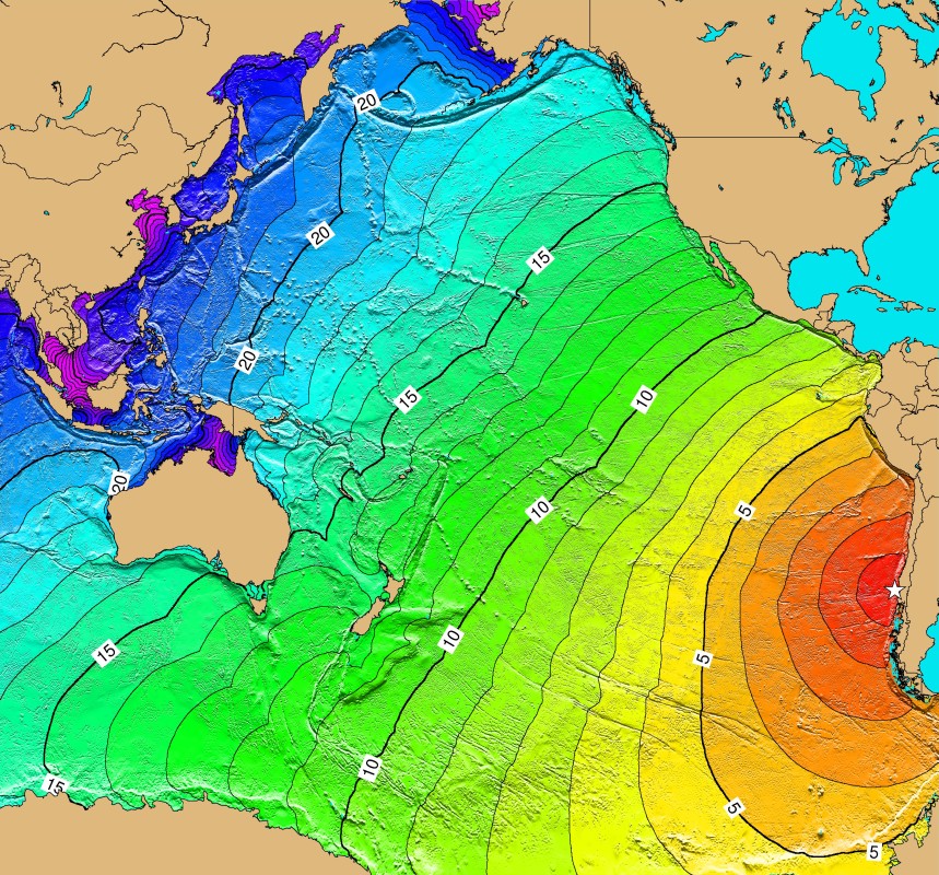
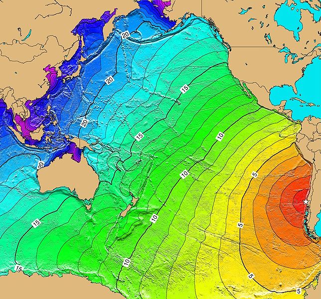
Tsunami spread after the Great Chilean earthquake
摘要[編輯]
Español: Mapa con el avance del tsunami del terremoto de Valdivia, Chile, 22 de mayo de 1960
English: Tsunami-Travel-Time of the earthquake of Valdivia, Chile, May 22, 1960. Contours are one hour intervals.
- Source
- was NGDC Tsunami-Travel-Time Maps ; currently see https://earthquake.usgs.gov/earthquakes/world/events/1960_05_22_tsunami.php
授權條款[編輯]
本圖像屬於公有領域,因該作品最初來自於美國國家海洋和大氣管理局職員的職務作品。
|
檔案歷史
點選日期/時間以檢視該時間的檔案版本。
| 日期/時間 | 縮圖 | 尺寸 | 用戶 | 備註 | |
|---|---|---|---|---|---|
| 目前 | 2006年3月11日 (六) 01:18 | | 859 × 800(324 KB) | B1mbo(對話 | 貢獻) | {{es|Mapa con el avance del tsunami del terremoto de Valdivia, 22 de mayo de 1960}} '''Source:''' [http://www.ngdc.noaa.gov/seg/hazard/img/1960_0522.jpg NGDC Tsunami-Travel-Time Maps] Category:Chile Category:Tsunamis ==Licensing== {{PD-USGov-NO |
無法覆蓋此檔案。
檔案用途
下列頁面有用到此檔案:
全域檔案使用狀況
以下其他 wiki 使用了這個檔案:
- ca.wikipedia.org 的使用狀況
- ckb.wikipedia.org 的使用狀況
- cs.wikipedia.org 的使用狀況
- de.wikipedia.org 的使用狀況
- en.wikipedia.org 的使用狀況
- en.wikiquote.org 的使用狀況
- es.wikipedia.org 的使用狀況
- fr.wikipedia.org 的使用狀況
- he.wikipedia.org 的使用狀況
- id.wikipedia.org 的使用狀況
- ja.wikipedia.org 的使用狀況
- ko.wikipedia.org 的使用狀況
- nl.wikipedia.org 的使用狀況
- nn.wikipedia.org 的使用狀況
- pl.wikipedia.org 的使用狀況
- pt.wikipedia.org 的使用狀況
- sh.wikipedia.org 的使用狀況
- sk.wikipedia.org 的使用狀況
- th.wikipedia.org 的使用狀況
- tr.wikipedia.org 的使用狀況
- uk.wikipedia.org 的使用狀況
- zh.wikipedia.org 的使用狀況