File:Turkey GeographicRegions.svg
跳转到导航
跳转到搜索

此SVG文件的PNG预览的大小:512 × 222像素。 其他分辨率:320 × 139像素 | 640 × 278像素 | 1,024 × 444像素 | 1,280 × 555像素 | 2,560 × 1,110像素。
原始文件 (SVG文件,尺寸为512 × 222像素,文件大小:597 KB)
说明
说明
添加一行文字以描述该文件所表现的内容
摘要[编辑]
| 描述 |
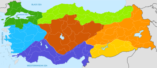
English: Color-coded geographic regions map of Turkey, with national and provincial borders superimposed. |
| 日期 | 2015年11月14日 (原始上传日期) |
| 来源 |
Original text : Personal work. Modified version of "Turkey_region_map_with_province_borders.svg" on Wikimedia Commons.) |
| 作者 | Nightstallion03 (talk) (Uploads) |
许可协议[编辑]
本文件采用知识共享署名 3.0 未本地化版本许可协议授权。
- 您可以自由地:
- 共享 – 复制、发行并传播本作品
- 修改 – 改编作品
- 惟须遵守下列条件:
- 署名 – 您必须对作品进行署名,提供授权条款的链接,并说明是否对原始内容进行了更改。您可以用任何合理的方式来署名,但不得以任何方式表明许可人认可您或您的使用。
原始上传日志[编辑]
The original description page was here. All following user names refer to en.wikipedia.
| 日期/时间 | 大小 | 用户 | 备注 |
|---|---|---|---|
| 2015-11-14 21:11 | 512×222× (615477 bytes) | Nightstallion03 | Personal work. Color-coded geographic regions map of Turkey, with national and provincial borders superimposed. Modified version of "Turkey_region_map_with_province_borders.svg" on Wikimedia Commons. |
文件历史
点击某个日期/时间查看对应时刻的文件。
| 日期/时间 | 缩略图 | 大小 | 用户 | 备注 | |
|---|---|---|---|---|---|
| 当前 | 2022年2月1日 (二) 13:37 | | 512 × 222(597 KB) | Kurmanbek(留言 | 贡献) | File uploaded using svgtranslate tool (https://svgtranslate.toolforge.org/). Added translation for tr. |
| 2016年4月23日 (六) 17:33 |  | 512 × 222(601 KB) | AmaryllisGardener(留言 | 贡献) | Transferred from en.wikipedia |
您不可以覆盖此文件。
文件用途
没有页面使用本文件。
全域文件用途
以下其他wiki使用此文件:
- bg.wikipedia.org上的用途
- ckb.wikipedia.org上的用途
- da.wikipedia.org上的用途
- en.wikipedia.org上的用途
- fi.wikipedia.org上的用途
- id.wikipedia.org上的用途
- ja.wikibooks.org上的用途
- la.wikipedia.org上的用途
- lv.wikipedia.org上的用途
- sq.wikipedia.org上的用途
- sr.wikipedia.org上的用途
- ta.wikipedia.org上的用途
- tr.wikipedia.org上的用途
- zh.wikipedia.org上的用途