File:Twaves.jpg
Fichier d’origine (2 550 × 944 pixels, taille du fichier : 345 kio, type MIME : image/jpeg)
Légendes
Légendes
Description
[modifier]
| Description |
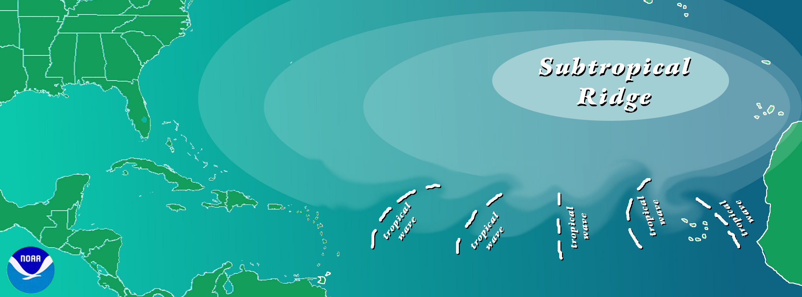
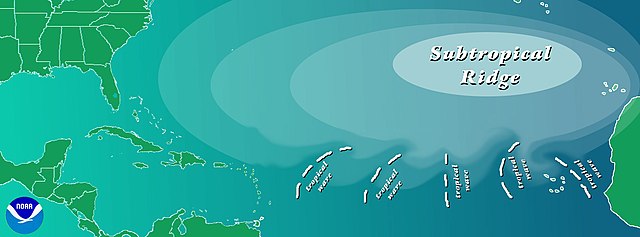
English: It has been recognized since at least the 1930s (Dunn 1940) that lower tropospheric (from the ocean surface to about 5 km [3 mi] with a maximum at 3 km [2 mi]) westward traveling disturbances often serve as the "seedling" circulations for a large proportion of tropical cyclones over the North Atlantic Ocean. Riehl (1945) helped to substantiate that these disturbances, now known as African easterly waves, had their origins over North Africa. While a variety of mechanisms for the origins of these waves were proposed in the next few decades, it was Burpee (1972) who documented that the waves were being generated by an instability of the African easterly jet. (This instability - known as baroclinic-barotropic instability - is where the value of the potential vorticity begins to decrease toward the north.) The jet arises as a result of the reversed lower-tropospheric temperature gradient over western and central North Africa due to extremely warm temperatures over the Saharan Desert in contrast with substantially cooler temperatures along the Gulf of Guinea coast.
The waves move generally toward the west in the lower tropospheric tradewind flow across the Atlantic Ocean. They are first seen usually in April or May and continue until October or November. The waves have a period of about 3 or 4 days and a wavelength of 2000 to 2500 km [1200 to 1500 mi], typically (Burpee 1974). One should keep in mind that the "waves" can be more correctly thought of as the convectively active troughs along an extended wave train. On average, about 60 waves are generated over North Africa each year, but it appears that the number that is formed has no relationship to how much tropical cyclone activity there is over the Atlantic each year. While only about 60% of the Atlantic tropical storms and minor hurricanes ( Saffir-Simpson Scale categories 1 and 2) originate from easterly waves, nearly 85% of the intense (or major) hurricanes have their origins as easterly waves (Landsea 1993). It is suggested, though, that nearly all of the tropical cyclones that occur in the Eastern Pacific Ocean can also be traced back to Africa (Avila and Pasch 1995). It is currently completely unknown how easterly waves change from year to year in both intensity and location and how these might relate to the activity in the Atlantic (and East Pacific). |
| Date | |
| Source | NOAA |
| Auteur | Chris Landsea |
| Autres versions | Œuvres dérivées de ce fichier : Twaves fr.jpg |
Conditions d’utilisation
[modifier]
Cette image est dans le domaine public car son contenu provient de la
National Oceanic and Atmospheric Administration , réalisé par un employé dans le cadre de ses activités professionnelles.
|
Historique du fichier
Cliquer sur une date et heure pour voir le fichier tel qu'il était à ce moment-là.
| Date et heure | Vignette | Dimensions | Utilisateur | Commentaire | |
|---|---|---|---|---|---|
| actuel | 26 janvier 2007 à 22:52 | 2 550 × 944 (345 kio) | Pflatau (d | contributions) | Contributed by Chris Landsea It has been recognized since at least the 1930s (Dunn 1940) that lower tropospheric (from the ocean surface to about 5 km [3 mi] with a maximum at 3 km [2 mi]) westward traveling disturbances often serve as the "seedling" cir |
Vous ne pouvez pas remplacer ce fichier.
Utilisations locales du fichier
Aucune page n’utilise ce fichier.
Utilisations du fichier sur d’autres wikis
Les autres wikis suivants utilisent ce fichier :
- Utilisation sur ko.wiktionary.org
- Utilisation sur nl.wikipedia.org
- Utilisation sur pl.wikipedia.org