File:Typhoon Etau 2003.jpg
跳至導覽
跳至搜尋

預覽大小:523 × 600 像素。 其他解析度:209 × 240 像素 | 418 × 480 像素 | 669 × 768 像素 | 893 × 1,024 像素 | 1,785 × 2,048 像素 | 6,800 × 7,800 像素。
原始檔案 (6,800 × 7,800 像素,檔案大小:5.9 MB,MIME 類型:image/jpeg)
說明
說明
添加單行說明來描述出檔案所代表的內容
| 警告 | 部分瀏覽器在瀏覽此圖片的完整大小時可能會遇到困難:該圖片中有數量巨大的像素點,可能無法完全載入或者導致您的瀏覽器停止回應。 |
|---|
摘要
[編輯]| 描述 |
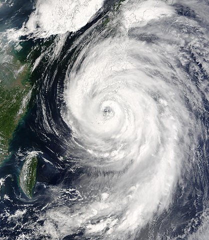
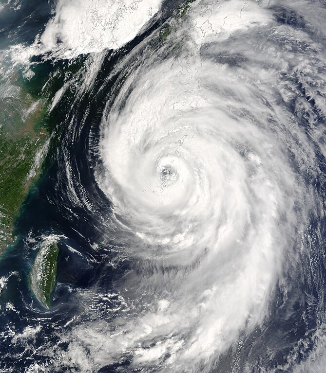
The MODIS instrument onboard NASA’s Terra spacecraft captured this bird’s-eye view of Typhoon Etau as it was buffeting the southern island chain of Okinawa, affecting airlines, a refinery and other industries. In this image the center of Etau is located just north of Nago city and is moving north at 20 kilometers per hour with sustained winds of 144 kilometers per hour. Forecasters are predicting the storm will reach Kagoshima city on Kyushu island tomorrow and then veer off to the Sea of Japan, avoiding Tokyo. |
|||||
| 日期 | ||||||
| 來源 | http://visibleearth.nasa.gov/view_rec.php?id=5719 | |||||
| 作者 | Jacques Descloitres, MODIS Rapid Response Team, NASA/GSFC | |||||
| 授權許可 (重用此檔案) |
|

檔案歷史
點選日期/時間以檢視該時間的檔案版本。
| 日期/時間 | 縮圖 | 尺寸 | 使用者 | 備註 | |
|---|---|---|---|---|---|
| 目前 | 2006年9月4日 (一) 16:59 | | 6,800 × 7,800(5.9 MB) | Good kitty(留言 | 貢獻) | == Summary == {{Information |Description=The MODIS instrument onboard NASA’s Terra spacecraft captured this bird’s-eye view of Typhoon Etau as it was buffeting the southern island chain of Okinawa, affecting airlines, a refinery and other industries. |
無法覆蓋此檔案。
檔案用途
沒有使用此檔案的頁面。
全域檔案使用狀況
以下其他 wiki 使用了這個檔案:
- en.wikipedia.org 的使用狀況
- es.wikipedia.org 的使用狀況
- ja.wikipedia.org 的使用狀況
- ko.wikipedia.org 的使用狀況
- pt.wikipedia.org 的使用狀況
- th.wikipedia.org 的使用狀況
- vi.wikipedia.org 的使用狀況
- zh.wikipedia.org 的使用狀況