File:Typhoon Halong 14 july 2002 0155Z.jpg
跳至導覽
跳至搜尋

預覽大小:458 × 599 像素。 其他解析度:183 × 240 像素 | 367 × 480 像素 | 587 × 768 像素 | 783 × 1,024 像素 | 1,566 × 2,048 像素 | 5,200 × 6,800 像素。
原始檔案 (5,200 × 6,800 像素,檔案大小:4.36 MB,MIME 類型:image/jpeg)
說明
說明
添加單行說明來描述出檔案所代表的內容
摘要[編輯]
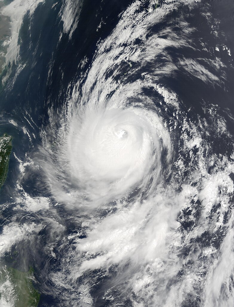
| 描述 | On July 14, 2002, Super Typhoon Halong was east of Taiwan (left edge) in the western Pacific Ocean. At the time this image was taken the storm was a Category 4 hurricane, with maximum sustained winds of 115 knots (132 miles per hour), but as recently as July 12, winds were at 135 knots (155 miles per hour). Halong has moved northwards and pounded Okinawa, Japan, with heavy rain and high winds, just days after tropical Storm Chataan hit the country, creating flooding and killing several people. The storm is expected to be a continuing threat on Monday and Tuesday. This image was acquired by the Moderate Resolution Imaging Spectroradiometer (MODIS) on the Terra satellite on July 14, 2002. | |||||
| 日期 | ||||||
| 來源 | http://visibleearth.nasa.gov/view_rec.php?id=3801 | |||||
| 作者 | Jacques Descloitres, MODIS Land Rapid Response Team, NASA/GSFC | |||||
| 授權許可 (重用此檔案) |
|

檔案歷史
點選日期/時間以檢視該時間的檔案版本。
| 日期/時間 | 縮圖 | 尺寸 | 用戶 | 備註 | |
|---|---|---|---|---|---|
| 目前 | 2006年12月2日 (六) 19:25 | | 5,200 × 6,800(4.36 MB) | Good kitty(對話 | 貢獻) | == Summary == {{Information |Description=On July 14, 2002, Super Typhoon Halong was east of Taiwan (left edge) in the western Pacific Ocean. At the time this image was taken the storm was a Category 4 hurricane, with maximum sustained winds of 115 knots ( |
無法覆蓋此檔案。
檔案用途
沒有使用此檔案的頁面。
全域檔案使用狀況
以下其他 wiki 使用了這個檔案:
- en.wikipedia.org 的使用狀況
- ja.wikipedia.org 的使用狀況
- zh.wikipedia.org 的使用狀況