File:Typhoon Utor 2013 making landfall.gif
跳至導覽
跳至搜尋
無更高解析度可提供。
Typhoon_Utor_2013_making_landfall.gif (720 × 480 像素,檔案大小:3.6 MB,MIME 類型:image/gif、循環、15 畫格、3.1秒)
說明
說明
添加單行說明來描述出檔案所代表的內容
摘要
[編輯]
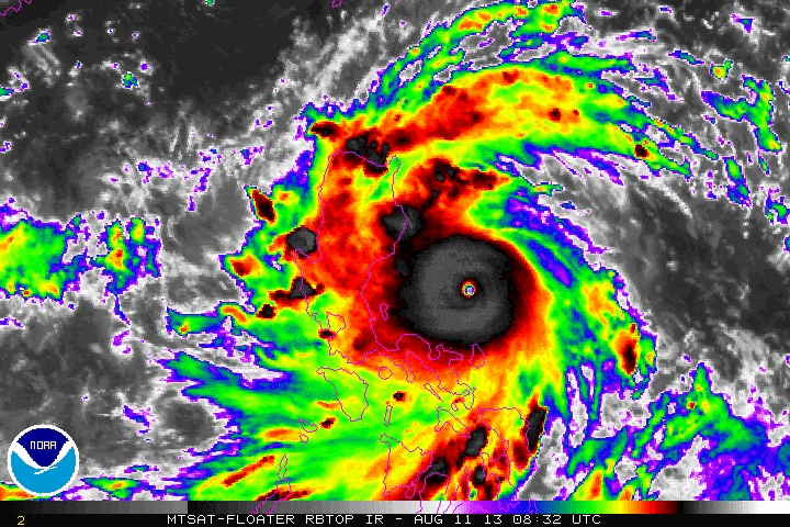
| 描述 |
English: Animated enhanced infrared satellite loop of Typhoon Utor (also known as Typhoon Labuyo in the Philippines) from 0832 UTC on August 11 to 2232 UTC August 11, 2013. These images show the storm at peak intensity and making landfall in the Luzon. |
| 日期 | |
| 來源 | http://www.ssd.noaa.gov/PS/TROP/floaters/ |
| 作者 | National Oceanic and Atmospheric Administration Satellite Services Division |
授權條款
[編輯]
本圖像屬於公有領域,因該作品最初來自於美國國家海洋和大氣管理局職員的職務作品。
|
檔案歷史
點選日期/時間以檢視該時間的檔案版本。
| 日期/時間 | 縮圖 | 尺寸 | 使用者 | 備註 | |
|---|---|---|---|---|---|
| 目前 | 2013年8月12日 (一) 03:01 | | 720 × 480(3.6 MB) | Kwlam259(留言 | 貢獻) | User created page with UploadWizard |
無法覆蓋此檔案。
檔案用途
沒有使用此檔案的頁面。
全域檔案使用狀況
以下其他 wiki 使用了這個檔案:
- en.wikipedia.org 的使用狀況
- tl.wikipedia.org 的使用狀況
- zh.wikipedia.org 的使用狀況