File:UN Palestine Partition Versions 1947.jpg

Πρωτότυπο αρχείο (1.370 × 2.838 εικονοστοιχεία, μέγεθος αρχείου: 1,46 MB, τύπος MIME: image/jpeg)
Λεζάντες
Λεζάντες
Σύνοψη[επεξεργασία]
| Περιγραφή |
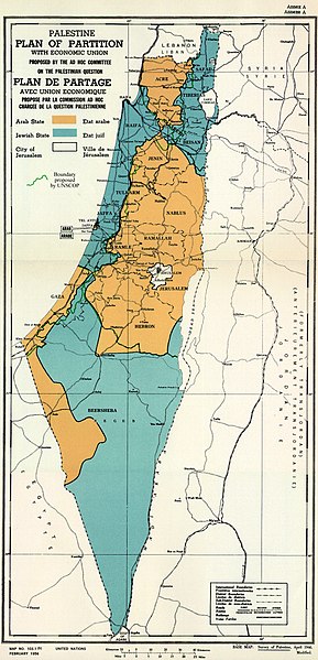
English: February 1956 Map of UN Partition Plan for Palestine, adopted 29 Nov 1947, with boundary of previous UNSCOP partition plan added in green. العربية: خريطة رسمية بعد قرار الأمم المتحدة بتاريخ 29 نوفمبر 1947م بتقسيم فلسطين إلى دولة عربية ويهودية وتحويل القدس لمدينة دولية. |
| Ημερομηνία | |
| Πηγή | m0103_1b.gif on PLAN OF PARTITION is from UNGA Resolution 181 (27 Nov 1947). Overdrawn UNSCOP boundary is from United Nations Special Committee on Palestine, Report to the General Assembly, 3 Sep 1947, Volume II, A/364, Add. 1. |
| Δημιουργός | Zero0000A/RES/181(II) |
| άλλες εκδόσεις |
.jpg)
.jpg)
.jpg)
.jpg)
Copyright status of map:
| This image is a map derived from a United Nations map.
Unless stated otherwise, UN maps are to be considered in the public domain. This applies worldwide. UN maps are, in principle, open source material and you can use them in your work or for making your own map. UN requests however that you delete the UN name, logo and reference number upon any modification to the map. Content of your map will be your responsibility. You can state in your publication, if you wish, something like: based on UN map … (map name, map number, revision number and date). See: Geospatial Information Section. And: Geospatial, location data for a better world. |
 |
Αδειοδότηση[επεξεργασία]
- Είστε ελεύθερος:
- να μοιραστείτε – να αντιγράψετε, διανέμετε και να μεταδώσετε το έργο
- να διασκευάσετε – να τροποποιήσετε το έργο
- Υπό τις ακόλουθες προϋποθέσεις:
- αναφορά προέλευσης – Θα πρέπει να κάνετε κατάλληλη αναφορά, να παρέχετε σύνδεσμο για την άδεια και να επισημάνετε εάν έγιναν αλλαγές. Μπορείτε να το κάνετε με οποιοδήποτε αιτιολογήσιμο λόγο, χωρίς όμως να εννοείται με οποιονδήποτε τρόπο ότι εγκρίνουν εσάς ή τη χρήση του έργου από εσάς.
- παρόμοια διανομή – Εάν αλλάξετε, τροποποιήσετε ή δημιουργήσετε πάνω στο έργο αυτό, μπορείτε να διανείμετε αυτό που θα προκύψει μόνο υπό τους όρους της ίδιας ή συμβατής άδειας με το πρωτότυπο.

|
This historical map image could be re-created using vector graphics as an SVG file. This has several advantages; see Commons:Media for cleanup for more information. If an SVG form of this image is available, please upload it and afterwards replace this template with
{{vector version available|new image name}}.
It is recommended to name the SVG file “UN Palestine Partition Versions 1947.svg”—then the template Vector version available (or Vva) does not need the new image name parameter. |


Ιστορικό αρχείου
Πατήστε σε μια ημερομηνία/ώρα για να δείτε το αρχείο όπως εμφανιζόταν εκείνη την χρονική στιγμή.
| Ημερομηνία/Ώρα | Μικρογραφία | Διαστάσεις | Χρήστης | Σχόλιο | |
|---|---|---|---|---|---|
| τρέχον | 12:07, 10 Αυγούστου 2013 | | 1.370 × 2.838 (1,46 MB) | Zero0000 (συζήτηση | Συνεισφορά) | User created page with UploadWizard |
Δεν μπορείτε να αντικαταστήσετε αυτό το αρχείο.
Χρήση αρχείου
Οι ακόλουθες 5 σελίδες χρησιμοποιούν προς αυτό το αρχείο:
- File:Beersheba in the Arab State in the UN Palestine Partition Versions 1947 (cropped).jpg
- File:Central area of the Arab State in the UN Palestine Partition Versions 1947 (cropped).jpg
- File:Northern Arab State in the UN Palestine Partition Versions 1947 (cropped).jpg
- File:The area around Isdud and Majdal in the UN Palestine Partition Versions 1947 (cropped).jpg
- File:UNGA Resolution 181 (II). Future government of Palestine Annex A Plan of Partition with Economic Union.gif
._Future_government_of_Palestine_Annex_A_Plan_of_Partition_with_Economic_Union.gif)
Καθολική χρήση αρχείου
Τα ακόλουθα άλλα wiki χρησιμοποιούν αυτό το αρχείο:
- Χρήση σε ar.wikipedia.org
- Χρήση σε arz.wikipedia.org
- Χρήση σε azb.wikipedia.org
- Χρήση σε az.wikipedia.org
- Χρήση σε bg.wikipedia.org
- Χρήση σε bn.wikipedia.org
- Χρήση σε cdo.wikipedia.org
- Χρήση σε cy.wikipedia.org
- Χρήση σε de.wikipedia.org
- Χρήση σε el.wikipedia.org
- Χρήση σε en.wikipedia.org
- 1948 Arab–Israeli War
- United Nations Partition Plan for Palestine
- Talk:United Nations Partition Plan for Palestine
- International zone
- International city
- Israel
- Arab localities in Israel
- Template talk:Largest cities of Israel
- Talk:1947–1948 civil war in Mandatory Palestine/Archive 2
- Wikipedia:Editor assistance/Requests/Archive 122
- Talk:Israel/Archive 47
- Talk:Israel/Archive 49
- November 1947
- Talk:Jerusalem/Archive 25
- User:Falcaorib
- Talk:Religion in Israel/Archive 1
- Nakba
- Wikipedia talk:Noticeboard for India-related topics/Archive 74
- User:Skingames2012/sandbox
- Χρήση σε es.wikipedia.org
- Χρήση σε et.wikipedia.org
- Χρήση σε eu.wikipedia.org
- Χρήση σε fa.wikipedia.org
- Χρήση σε fi.wikipedia.org
- Χρήση σε fr.wikipedia.org
Δείτε περισσότερη καθολική χρήση αυτού του αρχείου.