File:USA Mass Cape Cod location map.svg
跳至導覽
跳至搜尋

此 SVG 檔案的 PNG 預覽的大小:560 × 420 像素。 其他解析度:320 × 240 像素 | 640 × 480 像素 | 1,024 × 768 像素 | 1,280 × 960 像素 | 2,560 × 1,920 像素。
原始檔案 (SVG 檔案,表面大小:560 × 420 像素,檔案大小:264 KB)
說明
說明
添加單行說明來描述出檔案所代表的內容
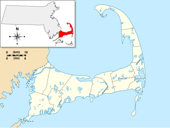
A location map of Cape Cod.
摘要
[編輯]
| 描述 |
English: Location Map specific to (and zoomed to) Cape Cod, made specifically for the "WikiProject Massachusetts - Cape Cod and the Islands" on the English Wikipedia, but it is available to all.
For detailed instructions and several examples showing the various ways to use this file, see the documentation page at en:Module:Location map/data/USA Cape Cod. Specifications:
|
| 日期 | |
| 來源 | 自己的作品 |
| 作者 | Grolltech |
| 其他版本 |
本檔案衍生自: USA Massachusetts location map.svg: |
| SVG開發 |
授權條款
[編輯]
我,本作品的著作權持有者,決定用以下授權條款發佈本作品:
此檔案採用共享創意 姓名標示-相同方式分享 3.0 未在地化版本授權條款。
- 您可以自由:
- 分享 – 複製、發佈和傳播本作品
- 重新修改 – 創作演繹作品
- 惟需遵照下列條件:
- 姓名標示 – 您必須指名出正確的製作者,和提供授權條款的連結,以及表示是否有對內容上做出變更。您可以用任何合理的方式來行動,但不得以任何方式表明授權條款是對您許可或是由您所使用。
- 相同方式分享 – 如果您利用本素材進行再混合、轉換或創作,您必須基於如同原先的相同或兼容的條款,來分布您的貢獻成品。
檔案歷史
點選日期/時間以檢視該時間的檔案版本。
| 日期/時間 | 縮圖 | 尺寸 | 用戶 | 備註 | |
|---|---|---|---|---|---|
| 目前 | 2013年5月13日 (一) 11:25 | | 560 × 420(264 KB) | Grolltech(對話 | 貢獻) | reshaped Monomoy; added overlay layers to facilitate reuse of this file |
| 2013年5月7日 (二) 22:45 |  | 560 × 420(189 KB) | Grolltech(對話 | 貢獻) | further reduced thickness of town boundaries, land outlines | |
| 2013年5月6日 (一) 08:10 |  | 560 × 420(206 KB) | Grolltech(對話 | 貢獻) | moved compass rose out of the way | |
| 2012年5月31日 (四) 17:39 |  | 560 × 420(205 KB) | Grolltech(對話 | 貢獻) | 1) moved scale legend to the left edge, and 2) reduced thickness of town boundaries, land outlines, lakes and ponds. Both of these changes are intended lessen the impact on readability of pushpin labels. | |
| 2012年5月13日 (日) 17:21 |  | 560 × 420(206 KB) | Grolltech(對話 | 貢獻) | added town boundaries | |
| 2012年5月13日 (日) 05:51 |  | 560 × 420(190 KB) | Grolltech(對話 | 貢獻) | {{Information |Description ={{en|1=Locator Map for Cape Cod exclusively. Made for "Wikiproject Massachusetts - Cape Cod and the Islands". Equirectangular projection, N/S stretching 130.0 %. Geographic limits of the map: Northern boundary: 42.104... |
無法覆蓋此檔案。
檔案用途
下列5個頁面有用到此檔案:
全域檔案使用狀況
以下其他 wiki 使用了這個檔案:
- ar.wikipedia.org 的使用狀況
- azb.wikipedia.org 的使用狀況
- ceb.wikipedia.org 的使用狀況
- en.wikipedia.org 的使用狀況
- Cape Cod
- Cape Cod Canal
- Provincetown Harbor
- Cape Cod Baseball League
- Kennedy Compound
- Eastham Windmill
- Sagamore Beach, Massachusetts
- Attaquin Beach
- Provincetown Historic District
- Race Point Light
- Center Methodist Church
- Provincetown Public Library (old)
- North Truro Air Force Station
- South Harwich, Massachusetts
- Hyannis Armory
- Louis Brandeis House
- Nauset Archeological District
- Ancient Burying Ground
- Chatham Windmill
- First Universalist Church (Provincetown, Massachusetts)
- Adams-Crocker-Fish House
- South Harwich Methodist Church
- Osterville Baptist Church
- Old Higgins Farm Windmill
- Universalist Society Meetinghouse
- Poor House and Methodist Cemetery
- Cove Burying Ground
- Bridge Road Cemetery
- Old Indian Meeting House
- Ahearn House and Summer House
- Josiah A. Ames House
- Atwood–Higgins Historic District
- Barnstable County Courthouse
- Avant House (Mashpee, Massachusetts)
- Capt. Rodney J. Baxter House
- George I. Briggs House
- Benjamin Baker Jr. House
- Capt. Seth Baker Jr. House
- Nathaniel Baker House
- Baxter Mill
- Lemuel B. Chase House
- Canary-Hartnett House
- Brewster Old King's Highway Historic District
檢視此檔案的更多全域使用狀況。