File:USGS Lake Superior syncline.png
跳转到导航
跳转到搜索
本预览的尺寸:800 × 539像素。 其他分辨率:320 × 216像素 | 640 × 432像素 | 1,007 × 679像素。
原始文件 (1,007 × 679像素,文件大小:603 KB,MIME类型:image/png)
说明
说明
添加一行文字以描述该文件所表现的内容
摘要
[编辑]
| 描述 |
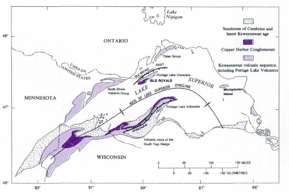
English: USGS Lake Superior syncline |
| 日期 | |
| 来源 | The Geologic Story of Isle Royale National Park, USGS Bulletin 1309 |
| 作者 | N. King Huber |
许可协议
[编辑]
此作品在美国属于公有领域,因为其是由美国政府的官员或雇员,基于其个人公务目的制作的作品,参考美国法典第17篇第1章第105条。
注意︰本模板仅适用于美国联邦政府的原创作品,不适用于任何美国州、属地、联邦个体、县、市或任何次级政府的作品。本模板也不适用于1978年以后由美国邮政署出版的邮票图案(参看美国版权局实践纲领第313.6(C)(1)条)。也不适用于部分美国硬币;参看美国铸币局使用条款。 |
 | |
| 本文件已被确认为免除已知的著作权法限制(包括所有相关权利)。 | ||
文件历史
点击某个日期/时间查看对应时刻的文件。
| 日期/时间 | 缩略图 | 大小 | 用户 | 备注 | |
|---|---|---|---|---|---|
| 当前 | 2017年5月7日 (日) 16:18 | | 1,007 × 679(603 KB) | Pi3.124(留言 | 贡献) | User created page with UploadWizard |
您不可以覆盖此文件。
文件用途
没有页面使用本文件。
全域文件用途
以下其他wiki使用此文件:
- en.wikipedia.org上的用途
- zh.wikipedia.org上的用途
元数据
分类:
- Geological maps of North America
- Keweenaw Peninsula
- Geological maps of Michigan
- Geological maps of Isle Royale National Park
- Geology of Michigan
- Geology of Wisconsin
- Geology of Minnesota
- Geology of Ontario
- Maps of synclines
- Copper Harbor Conglomerate
- Portage Lake Volcanic Series maps
- Cambrian sandstone
- Faults in North America
- Cambrian sandstone in Ontario