File:US insular areas FAS.png
跳转到导航
跳转到搜索

本预览的尺寸:800 × 337像素。 其他分辨率:320 × 135像素 | 640 × 269像素 | 1,482 × 624像素。
原始文件 (1,482 × 624像素,文件大小:32 KB,MIME类型:image/png)
说明
说明
添加一行文字以描述该文件所表现的内容
摘要[编辑]
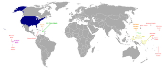
This is a map of the US Insular areas with the freely associated states of the Marshall Islands, Palau, and the Federated States of Micronesia (according to the US Office of Insular Affairs archive copy at the Wayback Machine, these islands are insular areas). The base map is Image:Dependent_territories_2007.png by User:Sesmith. This map is color coded according to each islands' status. Here is the key:
The USA
unorganized, unincorporated territory
organized, unincorporated territory
Commonwealth status
unorganized, incorporated Territory
country whose constitutional government is in free association with the USA
For an uncolor-coded map, see Image:US_insular_areas-B FAS.png. For a version without the freely associated states, see Image:US_insular_areas.png.
The previous map is PD; because of this, this map is too.
许可协议[编辑]
我,本作品著作权人,特此采用以下许可协议发表本作品:
| 我,本作品著作权人,释出本作品至公有领域。这适用于全世界。 在一些国家这可能不合法;如果是这样的话,那么: 我无条件地授予任何人以任何目的使用本作品的权利,除非这些条件是法律规定所必需的。 |
文件历史
点击某个日期/时间查看对应时刻的文件。
| 日期/时间 | 缩略图 | 大小 | 用户 | 备注 | |
|---|---|---|---|---|---|
| 当前 | 2008年3月5日 (三) 05:00 | | 1,482 × 624(32 KB) | Hoshie(留言 | 贡献) | == Summary == This is a map of the US Insular areas with the freely associated states of the Marshall Islands, Palau, and the Federated States of Micronesia (according to the [http://www.doi.gov/oia/Islandpages/political_types.htm US Office of Insular Af |
您不可以覆盖此文件。
文件用途
以下页面使用本文件:
全域文件用途
以下其他wiki使用此文件:
- ckb.wikipedia.org上的用途
- en.wikipedia.org上的用途
- fa.wikipedia.org上的用途
- id.wikipedia.org上的用途
- mzn.wikipedia.org上的用途
- nl.wikipedia.org上的用途
- ru.wikipedia.org上的用途
- tg.wikipedia.org上的用途
- zh.wikipedia.org上的用途