File:Ukraine under russian occupation.svg
Zur Navigation springen
Zur Suche springen

Gröössi vor PNG-Vorschou vor SVG-Datei: 800 × 538 Pixel. Wyteri Ufflösige: 320 × 215 Pixel | 640 × 430 Pixel | 1.024 × 688 Pixel | 1.280 × 860 Pixel | 2.560 × 1.720 Pixel | 3.780 × 2.540 Pixel.
Originaldatei (SVG-Datei, Basisgrößi: 3.780 × 2.540 Pixel, Dateigrößi: 1,85 MB)
Bildtexte
Kurzbeschreibungen
Ergänze eine einzeilige Erklärung, was diese Datei darstellt.
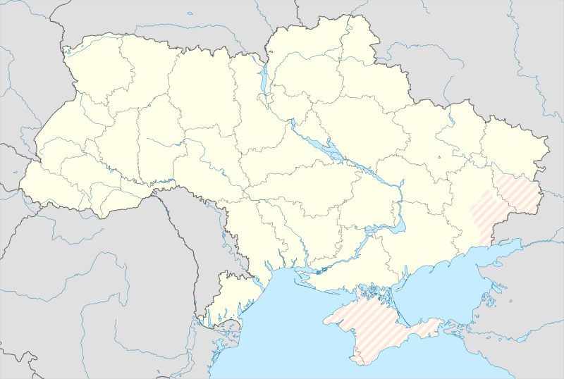
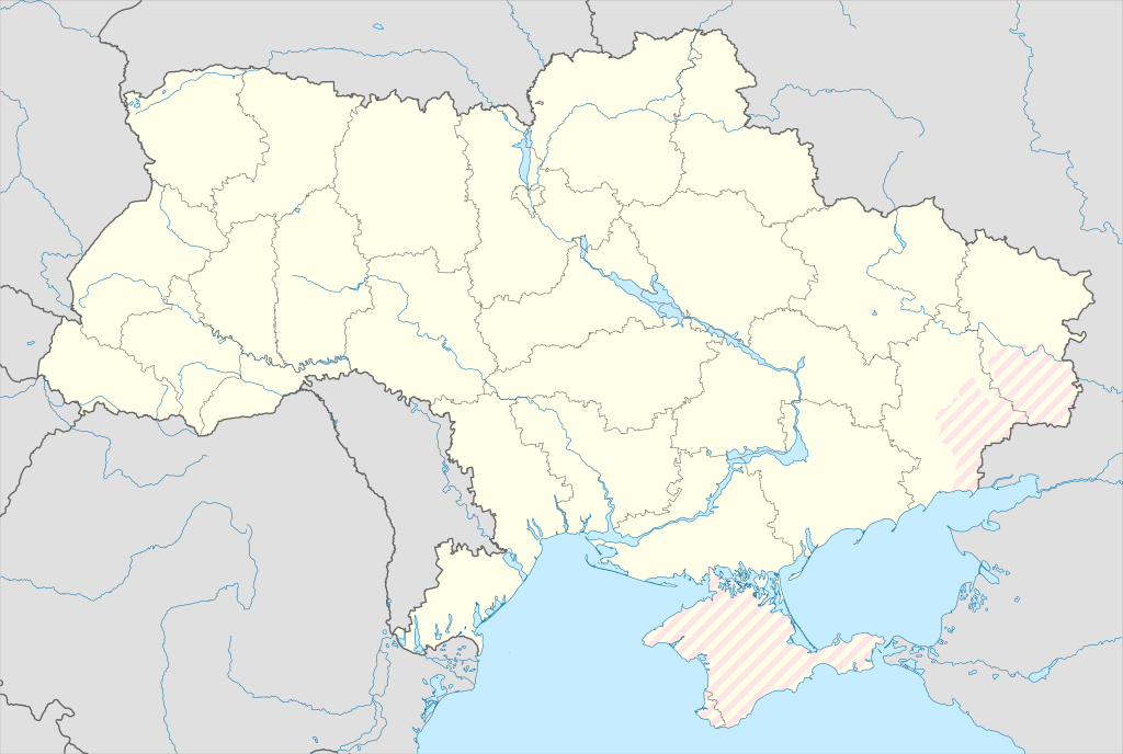
Map of Ukraine with zones of russian occupation
Bschryybig
[ändere]| Bschryybig |
English: Location map of Ukraine under russian occupation.
Українська: Карта України з зонами російської окупації. |
| Datum | |
| Quälle |
Eigenes Werk mittels: Ukraine adm location map improved.svg, according to
|
| Urheber | Yakiv Gluck |
| Anderi Versione |
|
| SVG‑Erstellung | Diese Landkarte wurde mit Adobe Illustrator erstellt. |


Lizänzierig
[ändere]
Ich haa s Urheberrächt an däm Wärch un vereffetlig s dodermit unter däre Lizänz:
Diese Datei ist lizenziert unter der Creative-Commons-Lizenz „Namensnennung – Weitergabe unter gleichen Bedingungen 4.0 international“.
- Du derfsch:
- des Wärch an anderi wytergee – des Wärch kopiere, verbreite un ibertrage
- des Wärch verändere – des Wärch aapasse
- Unter däne Bedingige:
- Namenännig – Du muesch aagmässeni Aagabe zum Urheber un dr Rächt mache, e Link zue dr Lizänz zuefiege un aagee, eb Änderige gmacht wore sin. Die Aagabe chenne in ere aagmässene Art gmacht wäre, aber nit eso, ass dr Yydruck entstoht, ass dr Lizänzgeber Dii oder Dyy Gebruch vum Wärch unterstitze un guetheiße.
- Wytergab unter glyche Bedingige – Wänn du des Wärch veränderesch, umwandlesch oder druf ufböusch, no derfsch s Ergebnis nume unter dr glyche oder ere kumpatible Lizänz wie s Orginal vereffetlige.
Dateiversione
Klick uf e Zytpunkt zu aazeige, wie s dert usgsäh het.
| Version vom | Vorschaubild | Mäß | Benutzer | Kommentar | |
|---|---|---|---|---|---|
| aktuell | 02:45, 17. Mei 2024 | | 3.780 × 2.540 (1,85 MB) | Physeters (Diskussion | Byträg) | add detail to dnipro delta |
| 15:45, 9. Aug. 2023 |  | 3.780 × 2.540 (1,36 MB) | Dƶoxar (Diskussion | Byträg) | Until the war ends it has no sense to maintain another map with actual frontline | |
| 09:32, 25. Jul. 2023 |  | 3.780 × 2.540 (1,64 MB) | ASDFPM (Diskussion | Byträg) | Reverted to version as of 17:17, 3 October 2022 (UTC) | |
| 02:45, 12. Nov. 2022 |  | 3.780 × 2.540 (1,36 MB) | Qexypnos (Diskussion | Byträg) | Reverted to version as of 17:02, 3 March 2018 (UTC) | |
| 17:17, 3. Okt. 2022 |  | 3.780 × 2.540 (1,64 MB) | Janitoalevic (Diskussion | Byträg) | Update | |
| 17:02, 3. Mär. 2018 |  | 3.780 × 2.540 (1,36 MB) | Yakiv Gluck (Diskussion | Byträg) | improved using new adm loc map | |
| 01:08, 27. Jan. 2018 |  | 1.546 × 1.038 (457 KB) | Yakiv Gluck (Diskussion | Byträg) | {{Information |Description ={{en|Location map of Ukraine under russian occupation.}} {{uk|Карта України з зонами російської окупації.}} |Source =own work, using [[:F... |
Du chasch die Datei nit iberschryybe.
Verwändig vu dr Datei
Die 8 Syte bruuche die Datei:
- User:Magog the Ogre/Maps of conflicts/2022 November
- User:Magog the Ogre/Maps of conflicts/2022 October
- User:Magog the Ogre/Maps of conflicts/2023 August
- User:Magog the Ogre/Maps of conflicts/2023 July
- User:Magog the Ogre/Maps of conflicts/2024 May
- File:Ukraine (1991-2014) location map.svg
- File:Ukraine according to Russian claims (2022) location map (1917 highlighted).svg
- File:Ukraine under russian occupation grey.svg
_location_map.svg)
_location_map_(1917_highlighted).svg)
Wältwyti Dateinutzig
Die andere Wikis bruche die Datei:
- Gebruch uf an.wikipedia.org
- Gebruch uf de.wikipedia.org
- Gebruch uf en.wikipedia.org
- Gebruch uf es.wikipedia.org
Wältwyti Verwändig vu däre Datei aaluege.