File:Ukraine under russian occupation.svg
Salta a la navegació
Salta a la cerca

Mida d'aquesta previsualització PNG del fitxer SVG: 800 × 538 píxels. Altres resolucions: 320 × 215 píxels | 640 × 430 píxels | 1.024 × 688 píxels | 1.280 × 860 píxels | 2.560 × 1.720 píxels | 3.780 × 2.540 píxels.
Fitxer original (fitxer SVG, nominalment 3.780 × 2.540 píxels, mida del fitxer: 1,85 Mo)
Llegendes
Llegendes
Afegeix una explicació d'una línia del que representa aquest fitxer
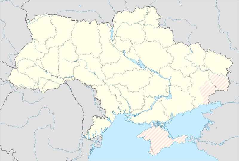
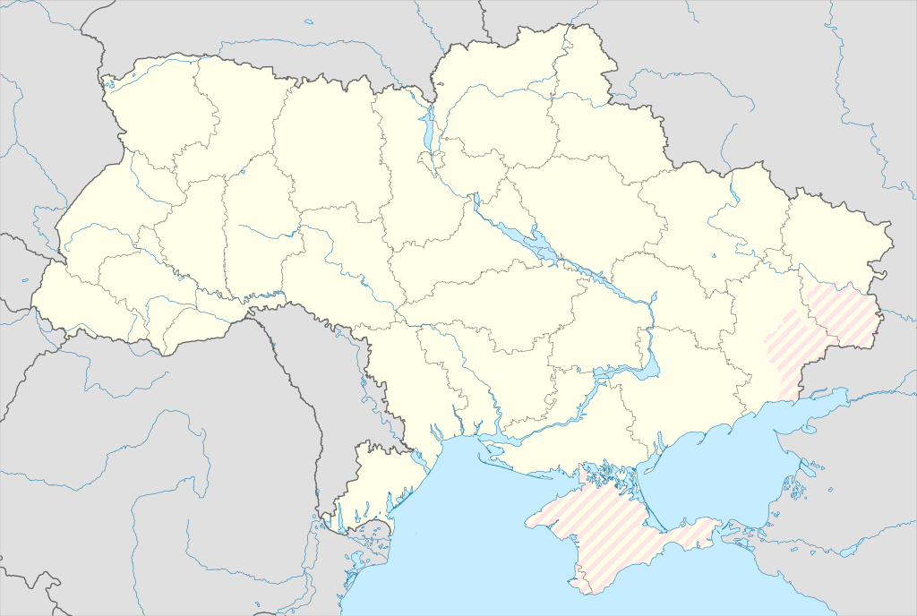
Map of Ukraine with zones of russian occupation
Resum
[modifica]| Descripció |
English: Location map of Ukraine under russian occupation.
Українська: Карта України з зонами російської окупації. |
| Data | |
| Font |
Own work using: Ukraine adm location map improved.svg, according to
|
| Autor | Yakiv Gluck |
| Altres versions |
|
| SVG genesis | Aquesta imatge vectorial ha estat creada amb Adobe Illustrator |


Llicència
[modifica]
Jo, el titular dels drets d'autor d'aquest treball, el public sota la següent llicència:
This file is licensed under the Creative Commons Attribution-Share Alike 4.0 International license.
- Sou lliure de:
- compartir – copiar, distribuir i comunicar públicament l'obra
- adaptar – fer-ne obres derivades
- Amb les condicions següents:
- reconeixement – Heu de donar la informació adequada sobre l'autor, proporcionar un enllaç a la llicència i indicar si s'han realitzat canvis. Podeu fer-ho amb qualsevol mitjà raonable, però de cap manera no suggereixi que l'autor us dóna suport o aprova l'ús que en feu.
- compartir igual – Si modifiqueu, transformeu, o generareu amb el material, haureu de distribuir les vostres contribucions sota una llicència similar o una de compatible com l'original
Historial del fitxer
Cliqueu una data/hora per veure el fitxer tal com era aleshores.
| Data/hora | Miniatura | Dimensions | Usuari/a | Comentari | |
|---|---|---|---|---|---|
| actual | 02:45, 17 maig 2024 | | 3.780 × 2.540 (1,85 Mo) | Physeters (discussió | contribucions) | add detail to dnipro delta |
| 15:45, 9 ago 2023 |  | 3.780 × 2.540 (1,36 Mo) | Dƶoxar (discussió | contribucions) | Until the war ends it has no sense to maintain another map with actual frontline | |
| 09:32, 25 jul 2023 |  | 3.780 × 2.540 (1,64 Mo) | ASDFPM (discussió | contribucions) | Reverted to version as of 17:17, 3 October 2022 (UTC) | |
| 02:45, 12 nov 2022 |  | 3.780 × 2.540 (1,36 Mo) | Qexypnos (discussió | contribucions) | Reverted to version as of 17:02, 3 March 2018 (UTC) | |
| 17:17, 3 oct 2022 |  | 3.780 × 2.540 (1,64 Mo) | Janitoalevic (discussió | contribucions) | Update | |
| 17:02, 3 març 2018 |  | 3.780 × 2.540 (1,36 Mo) | Yakiv Gluck (discussió | contribucions) | improved using new adm loc map | |
| 01:08, 27 gen 2018 |  | 1.546 × 1.038 (457 Ko) | Yakiv Gluck (discussió | contribucions) | {{Information |Description ={{en|Location map of Ukraine under russian occupation.}} {{uk|Карта України з зонами російської окупації.}} |Source =own work, using [[:F... |
No podeu sobreescriure aquest fitxer.
Ús del fitxer
Les 8 pàgines següents utilitzen aquest fitxer:
- User:Magog the Ogre/Maps of conflicts/2022 November
- User:Magog the Ogre/Maps of conflicts/2022 October
- User:Magog the Ogre/Maps of conflicts/2023 August
- User:Magog the Ogre/Maps of conflicts/2023 July
- User:Magog the Ogre/Maps of conflicts/2024 May
- File:Ukraine (1991-2014) location map.svg
- File:Ukraine according to Russian claims (2022) location map (1917 highlighted).svg
- File:Ukraine under russian occupation grey.svg
_location_map.svg)
_location_map_(1917_highlighted).svg)
Ús global del fitxer
Utilització d'aquest fitxer en altres wikis:
- Utilització a an.wikipedia.org
- Utilització a de.wikipedia.org
- Utilització a en.wikipedia.org
- Utilització a es.wikipedia.org
Vegeu més usos globals d'aquest fitxer.