File:Ukraine under russian occupation.svg
跳去導覽
跳去搵嘢

呢個「SVG」檔案嘅呢個「PNG」預覽嘅大細:800 × 538 像素。 第啲解像度:320 × 215 像素 | 640 × 430 像素 | 1,024 × 688 像素 | 1,280 × 860 像素 | 2,560 × 1,720 像素 | 3,780 × 2,540 像素。
原本檔案 (SVG檔案,表面大細: 3,780 × 2,540 像素,檔案大細:1.85 MB)
Captions
Captions
Add a one-line explanation of what this file represents
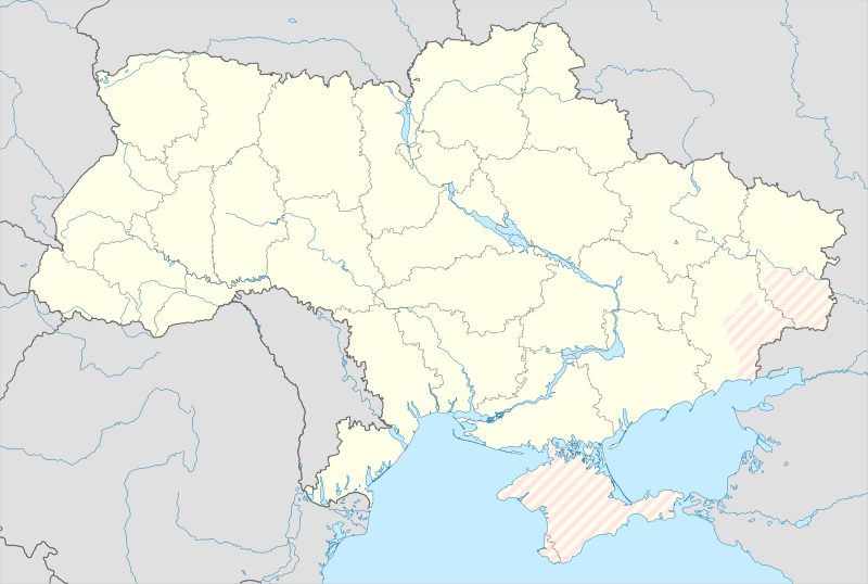
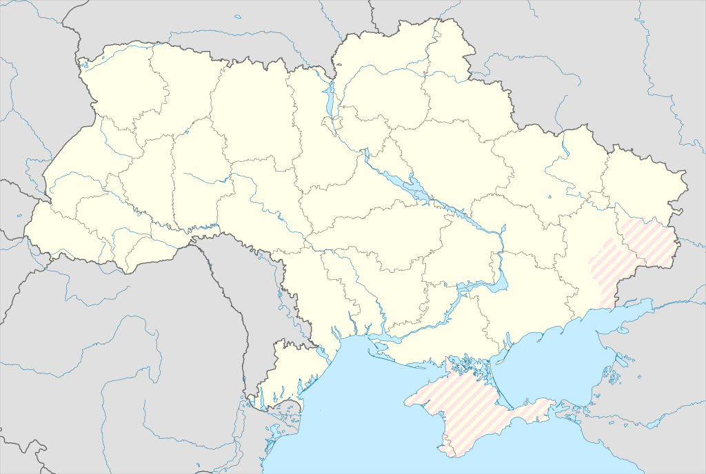
Map of Ukraine with zones of russian occupation
摘要
[編輯]| 描述 |
English: Location map of Ukraine under russian occupation.
Українська: Карта України з зонами російської окупації. |
| 日期 | |
| 來源 |
Own work using: Ukraine adm location map improved.svg, according to
|
| 作者 | Yakiv Gluck |
| Other versions |
|
| SVG genesis | This locator map was created with Adobe Illustrator. |


協議
[編輯]
我,呢份作品嘅作者,決定用以下許可發佈呢件作品:
This file is licensed under the Creative Commons Attribution-Share Alike 4.0 International license.
- 你可以:
- 去分享 – 複製、發佈同傳播呢個作品
- 再改 – 創作演繹作品
- 要遵照下面嘅條件:
- 署名 – 你一定要畀合適嘅表彰、畀返指向呢個授權條款嘅連結,同埋寫明有無改過嚟。你可以用任何合理方式去做,但唔可以用任何方式暗示授權人認可咗你或者你嘅使用方式。
- 相同方式分享 – 如果你用任何方式改過呢個作品,你必須要用返原本或者相似嘅條款發佈。
檔案歷史
撳個日期/時間去睇響嗰個時間出現過嘅檔案。
| 日期/時間 | 縮圖 | 尺寸 | 用戶 | 註解 | |
|---|---|---|---|---|---|
| 現時 | 2024年5月17號 (五) 02:45 | | 3,780 × 2,540(1.85 MB) | Physeters(傾偈 | 貢獻) | add detail to dnipro delta |
| 2023年8月9號 (三) 15:45 |  | 3,780 × 2,540(1.36 MB) | Dƶoxar(傾偈 | 貢獻) | Until the war ends it has no sense to maintain another map with actual frontline | |
| 2023年7月25號 (二) 09:32 |  | 3,780 × 2,540(1.64 MB) | ASDFPM(傾偈 | 貢獻) | Reverted to version as of 17:17, 3 October 2022 (UTC) | |
| 2022年11月12號 (六) 02:45 |  | 3,780 × 2,540(1.36 MB) | Qexypnos(傾偈 | 貢獻) | Reverted to version as of 17:02, 3 March 2018 (UTC) | |
| 2022年10月3號 (一) 17:17 |  | 3,780 × 2,540(1.64 MB) | Janitoalevic(傾偈 | 貢獻) | Update | |
| 2018年3月3號 (六) 17:02 |  | 3,780 × 2,540(1.36 MB) | Yakiv Gluck(傾偈 | 貢獻) | improved using new adm loc map | |
| 2018年1月27號 (六) 01:08 |  | 1,546 × 1,038(457 KB) | Yakiv Gluck(傾偈 | 貢獻) | {{Information |Description ={{en|Location map of Ukraine under russian occupation.}} {{uk|Карта України з зонами російської окупації.}} |Source =own work, using [[:F... |
你無得衾咗個檔案。
檔案用途
以下嘅8版用到呢個檔:
- User:Magog the Ogre/Maps of conflicts/2022 November
- User:Magog the Ogre/Maps of conflicts/2022 October
- User:Magog the Ogre/Maps of conflicts/2023 August
- User:Magog the Ogre/Maps of conflicts/2023 July
- User:Magog the Ogre/Maps of conflicts/2024 May
- File:Ukraine (1991-2014) location map.svg
- File:Ukraine according to Russian claims (2022) location map (1917 highlighted).svg
- File:Ukraine under russian occupation grey.svg
_location_map.svg)
_location_map_(1917_highlighted).svg)
全域檔案使用情況
下面嘅維基都用緊呢個檔案:
- an.wikipedia.org嘅使用情況
- de.wikipedia.org嘅使用情況
- en.wikipedia.org嘅使用情況
- es.wikipedia.org嘅使用情況
睇呢個檔案嘅更多全域使用情況。