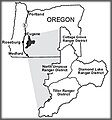
File:Umpqua Vicinity Map.jpg
出自Wikimedia Commons
跳至導覽
跳至搜尋
Umpqua_Vicinity_Map.jpg (270 × 290 像素,檔案大小:15 KB,MIME 類型:image/jpeg)
檔案資訊
結構化資料
說明
說明
添加單行說明來描述出檔案所代表的內容
摘要
[編輯]| 描述Umpqua Vicinity Map.jpg |
English: Vicinity map of the Umpqua National Forest, from the US Forest Service website. |
| 來源 | http://www.fs.fed.us/r6/umpqua/about/ |
| 作者 |
此檔案缺少作者資訊。
|
授權條款
[編輯]| Public domainPublic domainfalsefalse |
This image is a work of the Forest Service of the United States Department of Agriculture. As a work of the U.S. federal government, the image is in the public domain.
|
 |
原始上傳日誌
[編輯]The original description page was here. All following user names refer to en.wikipedia.
- 2007-12-13 01:48 Axcordion 270×290× (14865 bytes) Vacinity map of the Umpqua National Forest, from the US Forest Service website. http://www.fs.fed.us/r6/umpqua/about/
檔案歷史
點選日期/時間以檢視該時間的檔案版本。
| 日期/時間 | 縮圖 | 尺寸 | 使用者 | 備註 | |
|---|---|---|---|---|---|
| 目前 | 2009年3月20日 (五) 10:47 |  | 270 × 290(15 KB) | Urdangaray(留言 | 貢獻) | {{Information |Description={{en|Vicinity map of the Umpqua National Forest, from the US Forest Service website. http://www.fs.fed.us/r6/umpqua/about/}} |Source=Transferred from [http://en.wikipedia.org en.wikipedia] |Date=2007-12-13 (original upload date |
無法覆蓋此檔案。
檔案用途
沒有使用此檔案的頁面。
全域檔案使用狀況
以下其他 wiki 使用了這個檔案:
- en.wikipedia.org 的使用狀況
- es.wikipedia.org 的使用狀況
- he.wikipedia.org 的使用狀況
- zh.wikipedia.org 的使用狀況
詮釋資料
此檔案中包含其他資訊,這些資訊可能是由數位相機或掃描器在建立或數位化過程中所新增的。若檔案自原始狀態已被修改,一些詳細資料可能無法完整反映出已修改的檔案。
| _error | 0 |
|---|
