File:Un-bahrain.png

原始文件 (2,104 × 2,821像素,文件大小:863 KB,MIME类型:image/png)
说明
说明
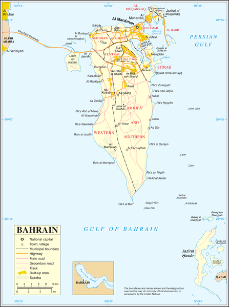
| This image is a map derived from a United Nations map.
Unless stated otherwise, UN maps are to be considered in the public domain. This applies worldwide. UN maps are, in principle, open source material and you can use them in your work or for making your own map. UN requests however that you delete the UN name, logo and reference number upon any modification to the map. Content of your map will be your responsibility. You can state in your publication, if you wish, something like: based on UN map … (map name, map number, revision number and date). See: Geospatial Information Section. And: Geospatial, location data for a better world. |
 |
文件历史
点击某个日期/时间查看对应时刻的文件。
| 日期/时间 | 缩略图 | 大小 | 用户 | 备注 | |
|---|---|---|---|---|---|
| 当前 | 2007年10月23日 (二) 02:51 | | 2,104 × 2,821(863 KB) | Jeroen(留言 | 贡献) | {{UN map}} Category:Maps of Bahrain |
您不可以覆盖此文件。
文件用途
没有页面使用本文件。
全域文件用途
以下其他wiki使用此文件:
- ar.wikipedia.org上的用途
- az.wikipedia.org上的用途
- bn.wikipedia.org上的用途
- el.wikipedia.org上的用途
- en.wikipedia.org上的用途
- Transport in Bahrain
- Sitra
- Amwaj Islands
- Muharraq Island
- Durrat Al Bahrain
- Halat Nuaim
- Outline of Bahrain
- Bahrain Island
- Umm an Nasan
- Nabih Saleh
- Jidda Island
- Umm as Sabaan
- Bahrain light rail network
- Northern City
- Passport Island
- Al Dar Island
- Diyar Al Muharraq
- Nurana Islands
- Prince Khalifa Bin Salman Island
- Qassar al Qulayʽah
- Reef Island, Bahrain
- South Sitra Island
- Al Garum Islands
- Qassar Khusayfah
- eo.wikipedia.org上的用途
- es.wikipedia.org上的用途
- fa.wikipedia.org上的用途
查看此文件的更多全域用途。