File:Un-chad.png

თავდაპირველი ფაილი (1 617 × 2 078 პიქსელი, ფაილის ზომა: 1,43 მბ, MIME ტიპი: image/png)
Captions
Captions
რეზიუმე[რედაქტირება]
| აღწერა |
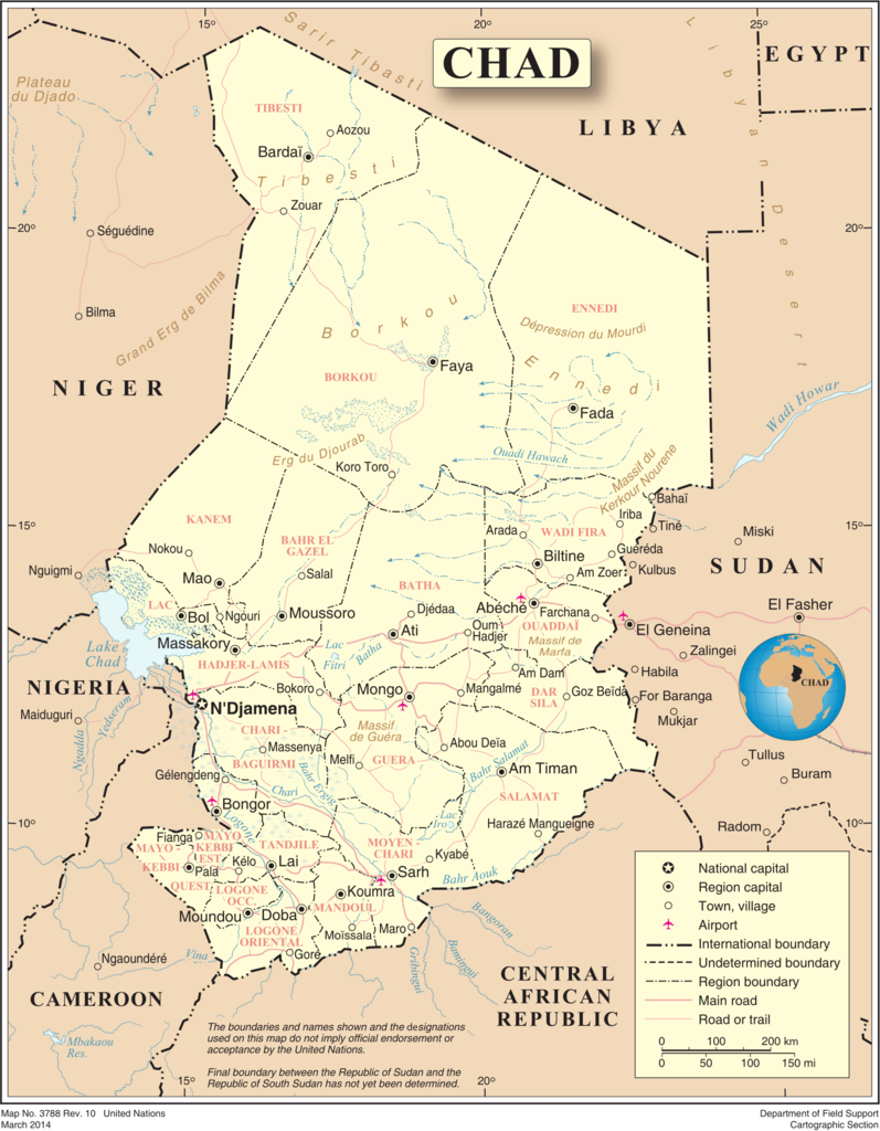
English: Map of Chad, showing region names and borders as of 2007. Based on UN map number 3788 (modified to remove UN name and reference number). |
| თარიღი | |
| წყარო |
|
| ავტორი | United Nations, Cartographic Section |
| უფლება (ფაილის მეორეული გამოყენება) |
Public domain |
ლიცენზია[რედაქტირება]
| This image is a map derived from a United Nations map.
Unless stated otherwise, UN maps are to be considered in the public domain. This applies worldwide. UN maps are, in principle, open source material and you can use them in your work or for making your own map. UN requests however that you delete the UN name, logo and reference number upon any modification to the map. Content of your map will be your responsibility. You can state in your publication, if you wish, something like: based on UN map … (map name, map number, revision number and date). See: Geospatial Information Section. And: Geospatial, location data for a better world. |
 |
ფაილის ისტორია
დააწკაპუნეთ თარიღზე/დროზე, რათა იხილოთ ფაილი, როგორც ის მაშინ გამოიყურებოდა.
| თარიღი/დრო | მინიატიურა | განზომილებები | მომხმარებელი | კომენტარი | |
|---|---|---|---|---|---|
| მიმდინარე | 16:37, 14 იანვარი 2016 | | 1 617 × 2 078 (1,43 მბ) | Bstouttt (განხილვა | წვლილი) | March 2014. United Nations. Chad http://www.un.org/Depts/Cartographic/map/profile/chad.pdf |
| 00:49, 24 ოქტომბერი 2007 |  | 2 348 × 2 947 (1,38 მბ) | Jeroen (განხილვა | წვლილი) | {{UN map}} Category:Maps of Chad |
თქვენ არ შეგიძლიათ ამ ფაილზე გადაწერა.
ფაილის გამოყენება
ეს ფაილი არცერთ გვერდზე არ გამოიყენება.
ფაილის გლობალური გამოყენება
ეს ფაილი გამოიყენება შემდეგ ვიკებში:
- გამოყენება avk.wikipedia.org-ში
- გამოყენება en.wikipedia.org-ში
- გამოყენება fa.wikipedia.org-ში
- გამოყენება fr.wikipedia.org-ში
- გამოყენება hu.wikipedia.org-ში
- გამოყენება ig.wikipedia.org-ში
- გამოყენება ka.wikipedia.org-ში
- გამოყენება mk.wikipedia.org-ში
- გამოყენება ms.wikipedia.org-ში
- გამოყენება nl.wikipedia.org-ში
- გამოყენება pl.wiktionary.org-ში
- გამოყენება stq.wikipedia.org-ში
- გამოყენება tl.wikipedia.org-ში
- გამოყენება tr.wikipedia.org-ში
- გამოყენება uk.wikipedia.org-ში
- გამოყენება ur.wikipedia.org-ში
- გამოყენება www.wikidata.org-ში
- გამოყენება zh.wikipedia.org-ში