File:Un-myanmar.png
মূল ফাইল (২,৩৬৬ × ৩,০৯২ পিক্সেল, ফাইলের আকার: ১.৮৩ মেগাবাইট, এমআইএমই ধরন: image/png)
ক্যাপশনসমূহ
ক্যাপশন
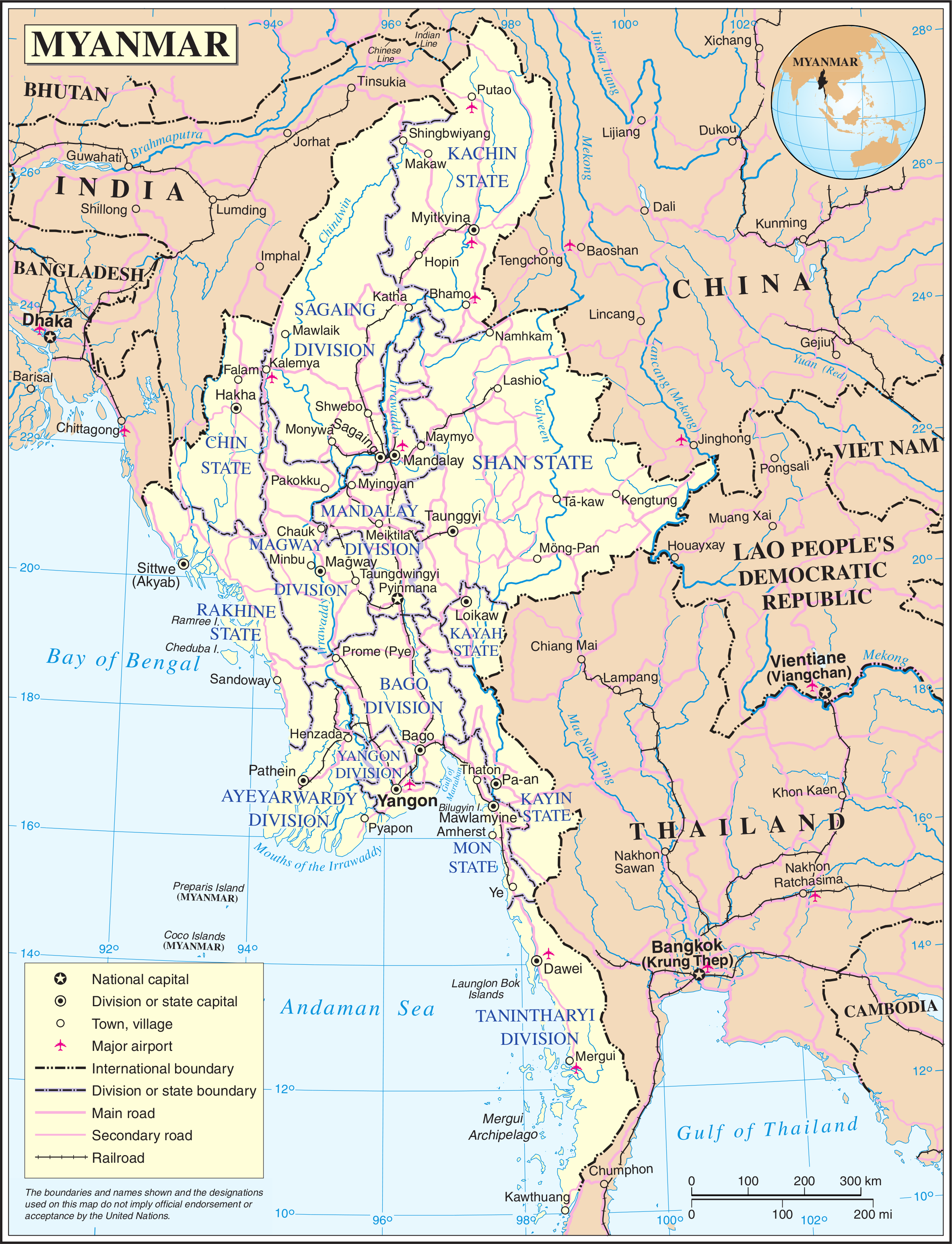
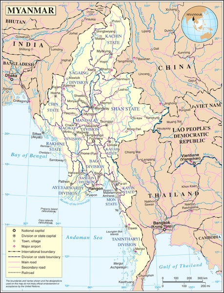
Map of Myanmar. Based on the UN map, but the location capital has been updated by me (the original uploader).
| This image is a map derived from a United Nations map.
Unless stated otherwise, UN maps are to be considered in the public domain. This applies worldwide. UN maps are, in principle, open source material and you can use them in your work or for making your own map. UN requests however that you delete the UN name, logo and reference number upon any modification to the map. Content of your map will be your responsibility. You can state in your publication, if you wish, something like: based on UN map … (map name, map number, revision number and date). See: Geospatial Information Section. And: Geospatial, location data for a better world. |
 |
ফাইলের ইতিহাস
যেকোনো তারিখ/সময়ে ক্লিক করে দেখুন ফাইলটি তখন কী অবস্থায় ছিল।
| তারিখ/সময় | সংক্ষেপচিত্র | মাত্রা | ব্যবহারকারী | মন্তব্য | |
|---|---|---|---|---|---|
| বর্তমান | ২১:১১, ১৩ মে ২০০৮ | | ২,৩৬৬ × ৩,০৯২ (১.৮৩ মেগাবাইট) | Mahahahaneapneap (আলোচনা | অবদান) | Compressed |
| ০১:৩৬, ২৪ অক্টোবর ২০০৭ |  | ২,৩৬৬ × ৩,০৯২ (২.৪২ মেগাবাইট) | Jeroen (আলোচনা | অবদান) | Map of Myanmar. Based on the UN map, but the location capital has been updated by me (the original uploader). {{UN map}} Category:Maps of Myanmar |
আপনি এই ফাইলটি প্রতিস্থাপন করতে পারবেন না।
ফাইলের ব্যবহার
এই ফাইল ব্যবহার করে এমন কোনো পাতা নেই।
ফাইলের বৈশ্বিক ব্যবহার
নিচের অন্যান্য উইকিগুলো এই ফাইলটি ব্যবহার করে:
- az.wikipedia.org-এ ব্যবহার
- bn.wikipedia.org-এ ব্যবহার
- en.wikipedia.org-এ ব্যবহার
- fi.wikipedia.org-এ ব্যবহার
- fr.wikipedia.org-এ ব্যবহার
- gl.wikipedia.org-এ ব্যবহার
- kg.wikipedia.org-এ ব্যবহার
- pl.wiktionary.org-এ ব্যবহার
- shn.wikipedia.org-এ ব্যবহার
- simple.wikipedia.org-এ ব্যবহার
- si.wikipedia.org-এ ব্যবহার
- sl.wikipedia.org-এ ব্যবহার
- uk.wikipedia.org-এ ব্যবহার
- zh.wikipedia.org-এ ব্যবহার