File:Utm-zones.jpg

原始文件 (2,048 × 1,024像素,文件大小:821 KB,MIME类型:image/jpeg)
说明
说明
摘要
[编辑]
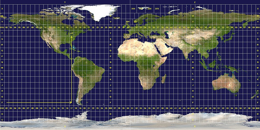
Longitude zones are six degrees wide. They are numbered from 01 at 180° west, increasing towards the east until 60 at 180° east.
Latitude zones are 8° high. They are lettered from C to X, omitting the letters "I" and "O", beginning at 80° south. The letters A, B, Y and Z are used in the polar regions by the Universal Polar Stereographic grid system.
A grid reference is read "right, up", as indicated by the arrows. A reference is always written with the longitude zone first. In this example, "17T".
Exceptions to the system are apparent. The west coast of Norway is given a wider zone 32V, taking some space from the zone 31V that covers open water. The zones around Svalbard are also widened, effectively deleting some longitude zones at this latitude. Finally, the entire latitude zone "X" is extended an extra 4°, topping off at 84° north.许可协议
[编辑]
此作品在美国属于公有领域,因为其是由美国政府的官员或雇员,基于其个人公务目的制作的作品,参考美国法典第17篇第1章第105条。
注意︰本模板仅适用于美国联邦政府的原创作品,不适用于任何美国州、属地、联邦个体、县、市或任何次级政府的作品。本模板也不适用于1978年以后由美国邮政署出版的邮票图案(参看美国版权局实践纲领第313.6(C)(1)条)。也不适用于部分美国硬币;参看美国铸币局使用条款。 |
 | |
| 本文件已被确认为免除已知的著作权法限制(包括所有相关权利)。 | ||
This image was constructed from a public domain Visible Earth product of the Earth Observatory office of the United States government space agency NASA. It is based on a cylindrical equi-distant projection, and was marked up by custom software created specifically for the Wikipedia.
| 本文件采用知识共享署名-相同方式共享 3.0 未本地化版本许可协议授权。 受免責聲明的約束。 | ||
| ||
| 本许可协议标签作为GFDL许可协议更新的组成部分被添加至本文件。 |

|
已授权您依据自由软件基金会发行的无固定段落及封面封底文字(Invariant Sections, Front-Cover Texts, and Back-Cover Texts)的GNU自由文件许可协议1.2版或任意后续版本的条款,复制、传播和/或修改本文件。该协议的副本请见“GNU Free Documentation License”。 受免責聲明的約束。 |
文件历史
点击某个日期/时间查看对应时刻的文件。
| 日期/时间 | 缩略图 | 大小 | 用户 | 备注 | |
|---|---|---|---|---|---|
| 当前 | 2007年1月26日 (五) 11:08 | | 2,048 × 1,024(821 KB) | Jan Krymmel~commonswiki(留言 | 贡献) | The longitude and latitude zones in the Universal Transverse Mercator system. Longitude zones are six degrees wide. They are numbered from 01 at 180° west, increasing towards the east until 60 at 180° east. Latitude zones are 8° high. They are le |
您不可以覆盖此文件。
文件用途
没有页面使用本文件。
全域文件用途
以下其他wiki使用此文件:
- ar.wikipedia.org上的用途
- ast.wikipedia.org上的用途
- ca.wikipedia.org上的用途
- cs.wikipedia.org上的用途
- da.wikipedia.org上的用途
- de.wikipedia.org上的用途
- en.wikipedia.org上的用途
- es.wikipedia.org上的用途
- et.wikipedia.org上的用途
- eu.wikipedia.org上的用途
- fa.wikipedia.org上的用途
- he.wikipedia.org上的用途
- hu.wikipedia.org上的用途
- ilo.wikipedia.org上的用途
- ko.wikipedia.org上的用途
- mk.wikipedia.org上的用途
- nl.wikipedia.org上的用途
- no.wikipedia.org上的用途
- pl.wikipedia.org上的用途
- pt.wikipedia.org上的用途
- sv.wikipedia.org上的用途
- ta.wikipedia.org上的用途
- th.wikipedia.org上的用途
- uk.wikipedia.org上的用途
- zh.wikipedia.org上的用途