File:Viceroyalty of the New Spain 1819 (without Philippines).png
跳至導覽
跳至搜尋

預覽大小:800 × 596 像素。 其他解析度:320 × 238 像素 | 640 × 477 像素 | 1,024 × 763 像素 | 1,280 × 954 像素 | 1,600 × 1,192 像素。
原始檔案 (1,600 × 1,192 像素,檔案大小:668 KB,MIME 類型:image/png)
說明
說明
添加單行說明來描述出檔案所代表的內容

|
File:Mapa del Virreinato de la Nueva España (1819).svg是本檔案的向量版本。 如果品質不低,就應該優先使用該檔案,而非PNG檔案。
File:Viceroyalty of the New Spain 1819 (without Philippines).png → File:Mapa del Virreinato de la Nueva España (1819).svg
更多資訊請參閱Help:SVG/zh。 |
.svg) |
摘要
[編輯]| 描述 |
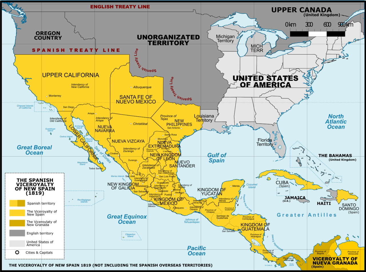
English: Viceroyalty of New Spain after the Adams-Onis Treaty of 1819 (Not including the Spanish overseas territories of the Pacific Ocean Español: Localidad del Virreinato de Nueva España después del Tratado de Adams-Onis en 1819 (Sin incluir los territorios españoles de ultramar del Océano Pacífico |
| 日期 | |
| 來源 |
A map created using information from the United States Geological Survey, an agency of the United States Department of Interior 1810, 1820 and from the Secretary of the Public Education of Mexico (Secretaría de Educación Pública de México) with 500 años de documentos 本圖形使用Adobe Photoshop創作。 |
| 作者 | Giggette |
| 其他版本 |
|

.png)
.png)

.png&action=edit§ion=1)
.png#Disputed)
| 拍攝地點 | | 位於此地的本圖片與其他圖片: OpenStreetMap |
|---|
.png¶ms=019.409500_N_-099.130700_E_globe:Earth_type:camera_type:satellite_region:MX_heading:0.00&language=zh-mo)
授權條款
[編輯].png&action=edit§ion=2)
我,本作品的著作權持有者,決定用以下授權條款發佈本作品:
此檔案採用共享創意 姓名標示-相同方式分享 3.0 未在地化版本授權條款。
- 您可以自由:
- 分享 – 複製、發佈和傳播本作品
- 重新修改 – 創作演繹作品
- 惟需遵照下列條件:
- 姓名標示 – 您必須指名出正確的製作者,和提供授權條款的連結,以及表示是否有對內容上做出變更。您可以用任何合理的方式來行動,但不得以任何方式表明授權條款是對您許可或是由您所使用。
- 相同方式分享 – 如果您利用本素材進行再混合、轉換或創作,您必須基於如同原先的相同或兼容的條款,來分布您的貢獻成品。

|
已授權您依據自由軟體基金會發行的無固定段落、封面文字和封底文字GNU自由文件授權條款1.2版或任意後續版本,對本檔進行複製、傳播和/或修改。該協議的副本列在GNU自由文件授權條款中。 |
您可以選擇您需要的授權條款。
檔案歷史
點選日期/時間以檢視該時間的檔案版本。
.png&uselang=zh-mo&dir=prev)
.png&uselang=zh-mo&offset=20130630055737)
.png&uselang=zh-mo&offset=&limit=20)
.png&uselang=zh-mo&offset=&limit=50)
.png&uselang=zh-mo&offset=&limit=100)
.png&uselang=zh-mo&offset=&limit=250)
.png&uselang=zh-mo&offset=&limit=500)
| 日期/時間 | 縮圖 | 尺寸 | 用戶 | 備註 | |
|---|---|---|---|---|---|
| 目前 | 2016年11月21日 (一) 02:41 | | 1,600 × 1,192(668 KB) | Giggette(對話 | 貢獻) | DTLS |
| 2016年11月21日 (一) 02:40 |  | 68 × 29(217位元組) | Giggette(對話 | 貢獻) | DTLS | |
| 2016年11月21日 (一) 01:49 |  | 1,600 × 1,192(667 KB) | Giggette(對話 | 貢獻) | Clearest | |
| 2014年6月1日 (日) 21:36 |  | 1,600 × 1,192(653 KB) | Giggette(對話 | 貢獻) | Details | |
| 2014年5月13日 (二) 21:17 |  | 1,600 × 1,192(653 KB) | Giggette(對話 | 貢獻) | Updating | |
| 2014年5月11日 (日) 23:48 |  | 1,500 × 1,117(549 KB) | Giggette(對話 | 貢獻) | Adding missed islands, names, information | |
| 2014年5月11日 (日) 22:20 |  | 1,501 × 1,117(547 KB) | Giggette(對話 | 貢獻) | Adding missed provinces and clarifying information | |
| 2014年5月6日 (二) 17:48 |  | 1,501 × 1,116(529 KB) | Giggette(對話 | 貢獻) | Details | |
| 2014年5月6日 (二) 17:24 |  | 1,449 × 1,078(501 KB) | Giggette(對話 | 貢獻) | Details | |
| 2013年6月30日 (日) 05:57 |  | 1,450 × 1,084(485 KB) | Giggette(對話 | 貢獻) | NV |
無法覆蓋此檔案。
檔案用途
下列11個頁面有用到此檔案:
- User:Giggette
- User:Giggette/cylindrical maps
- File:Mexico 1824 (equirectangular projection).png
- File:Nova Espanya a Mèxic.png
- File:Second Mexican Empire (equirectangular projection).png
- File:Spanish Caribbean Islands in the American Viceroyalties 1600.png
- File:Viceroyalty of New Spain 1819 (without Philippines).png (檔案重新導向)
- File:Viceroyalty of New Spain Location 1819 (without Philippines).png
- File:Viceroyalty of New Spain Location 1819 (without Philippines) 2.png (檔案重新導向)
- File:Viceroyalty of the New Spain 1800 (without Philippines).png
- File:Viceroyalty of the New Spain 1819 (without Philippines).png
.png)
.png)
.png&redirect=no)
.png)
_2.png&redirect=no)
全域檔案使用狀況
以下其他 wiki 使用了這個檔案:
- bn.wikipedia.org 的使用狀況
- en.wikipedia.org 的使用狀況
- es.wikipedia.org 的使用狀況
- fr.wikipedia.org 的使用狀況
- he.wikipedia.org 的使用狀況
- no.wikipedia.org 的使用狀況
- ro.wikipedia.org 的使用狀況
- sw.wikipedia.org 的使用狀況
- zh.wikipedia.org 的使用狀況
詮釋資料
.png&oldid=843971276)
分類:
- Maps of subdivisions of the Viceroyalty of New Spain
- Maps of the history of Mexico
- Maps of the history of the United States
- 1819 maps
- Maps of colonial California
- History of Arizona
- History of New Mexico
- Maps of the Captaincy General of Cuba
- Maps of Mexico (equirectangular projection)
- Mexico in the 1810s
- Adams–Onís Treaty
- Westward expansion of the United States