File:Viceroyalty of the New Spain 1819 (without Philippines).png
跳转到导航
跳转到搜索

本预览的尺寸:800 × 596像素。 其他分辨率:320 × 238像素 | 640 × 477像素 | 1,024 × 763像素 | 1,280 × 954像素 | 1,600 × 1,192像素。
原始文件 (1,600 × 1,192像素,文件大小:668 KB,MIME类型:image/png)
说明
说明
添加一行文字以描述该文件所表现的内容

|
File:Mapa del Virreinato de la Nueva España (1819).svg是此文件的矢量版本。 如果此文件质量不低于原点阵图,就应该将这个PNG格式文件替换为此文件。
File:Viceroyalty of the New Spain 1819 (without Philippines).png → File:Mapa del Virreinato de la Nueva España (1819).svg
更多信息请参阅Help:SVG/zh。 |
.svg) |
摘要
[编辑]| 描述 |
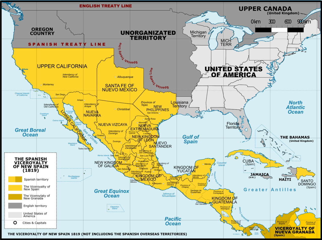
English: Viceroyalty of New Spain after the Adams-Onis Treaty of 1819 (Not including the Spanish overseas territories of the Pacific Ocean Español: Localidad del Virreinato de Nueva España después del Tratado de Adams-Onis en 1819 (Sin incluir los territorios españoles de ultramar del Océano Pacífico |
| 日期 | |
| 来源 |
A map created using information from the United States Geological Survey, an agency of the United States Department of Interior 1810, 1820 and from the Secretary of the Public Education of Mexico (Secretaría de Educación Pública de México) with 500 años de documentos 本图片使用Adobe Photoshop创作. |
| 作者 | Giggette |
| 其他版本 |
|

.png)
.png)

.png&action=edit§ion=1)
.png#Disputed)
| 相机位置 | | 在以下服务上查看本图像和附近其他图像: OpenStreetMap |
|---|
.png¶ms=019.409500_N_-099.130700_E_globe:Earth_type:camera_type:satellite_region:MX_heading:0.00&language=zh-my)
许可协议
[编辑].png&action=edit§ion=2)
我,本作品著作权人,特此采用以下许可协议发表本作品:
本文件采用知识共享署名-相同方式共享 3.0 未本地化版本许可协议授权。
- 您可以自由地:
- 共享 – 复制、发行并传播本作品
- 修改 – 改编作品
- 惟须遵守下列条件:
- 署名 – 您必须对作品进行署名,提供授权条款的链接,并说明是否对原始内容进行了更改。您可以用任何合理的方式来署名,但不得以任何方式表明许可人认可您或您的使用。
- 相同方式共享 – 如果您再混合、转换或者基于本作品进行创作,您必须以与原先许可协议相同或相兼容的许可协议分发您贡献的作品。

|
已授权您依据自由软件基金会发行的无固定段落及封面封底文字(Invariant Sections, Front-Cover Texts, and Back-Cover Texts)的GNU自由文件许可协议1.2版或任意后续版本的条款,复制、传播和/或修改本文件。该协议的副本请见“GNU Free Documentation License”。 |
您可以选择您需要的许可协议。
文件历史
点击某个日期/时间查看对应时刻的文件。
.png&uselang=zh-my&dir=prev)
.png&uselang=zh-my&offset=20130630055737)
.png&uselang=zh-my&offset=&limit=20)
.png&uselang=zh-my&offset=&limit=50)
.png&uselang=zh-my&offset=&limit=100)
.png&uselang=zh-my&offset=&limit=250)
.png&uselang=zh-my&offset=&limit=500)
| 日期/时间 | 缩略图 | 大小 | 用户 | 备注 | |
|---|---|---|---|---|---|
| 当前 | 2016年11月21日 (一) 02:41 | | 1,600 × 1,192(668 KB) | Giggette(留言 | 贡献) | DTLS |
| 2016年11月21日 (一) 02:40 |  | 68 × 29(217字节) | Giggette(留言 | 贡献) | DTLS | |
| 2016年11月21日 (一) 01:49 |  | 1,600 × 1,192(667 KB) | Giggette(留言 | 贡献) | Clearest | |
| 2014年6月1日 (日) 21:36 |  | 1,600 × 1,192(653 KB) | Giggette(留言 | 贡献) | Details | |
| 2014年5月13日 (二) 21:17 |  | 1,600 × 1,192(653 KB) | Giggette(留言 | 贡献) | Updating | |
| 2014年5月11日 (日) 23:48 |  | 1,500 × 1,117(549 KB) | Giggette(留言 | 贡献) | Adding missed islands, names, information | |
| 2014年5月11日 (日) 22:20 |  | 1,501 × 1,117(547 KB) | Giggette(留言 | 贡献) | Adding missed provinces and clarifying information | |
| 2014年5月6日 (二) 17:48 |  | 1,501 × 1,116(529 KB) | Giggette(留言 | 贡献) | Details | |
| 2014年5月6日 (二) 17:24 |  | 1,449 × 1,078(501 KB) | Giggette(留言 | 贡献) | Details | |
| 2013年6月30日 (日) 05:57 |  | 1,450 × 1,084(485 KB) | Giggette(留言 | 贡献) | NV |
您不可以覆盖此文件。
文件用途
以下11个页面使用本文件:
- User:Giggette
- User:Giggette/cylindrical maps
- File:Mexico 1824 (equirectangular projection).png
- File:Nova Espanya a Mèxic.png
- File:Second Mexican Empire (equirectangular projection).png
- File:Spanish Caribbean Islands in the American Viceroyalties 1600.png
- File:Viceroyalty of New Spain 1819 (without Philippines).png(文件重定向)
- File:Viceroyalty of New Spain Location 1819 (without Philippines).png
- File:Viceroyalty of New Spain Location 1819 (without Philippines) 2.png(文件重定向)
- File:Viceroyalty of the New Spain 1800 (without Philippines).png
- File:Viceroyalty of the New Spain 1819 (without Philippines).png
.png)
.png)
.png&redirect=no)
.png)
_2.png&redirect=no)
全域文件用途
以下其他wiki使用此文件:
- bn.wikipedia.org上的用途
- en.wikipedia.org上的用途
- es.wikipedia.org上的用途
- fr.wikipedia.org上的用途
- ro.wikipedia.org上的用途
- sw.wikipedia.org上的用途
- zh.wikipedia.org上的用途
元数据
.png&oldid=843971276)
分类:
- Maps of subdivisions of the Viceroyalty of New Spain
- Maps of the history of Mexico
- Maps of the history of the United States
- 1819 maps
- Maps of colonial California
- History of Arizona
- History of New Mexico
- Maps of the Captaincy General of Cuba
- Maps of Mexico (equirectangular projection)
- Mexico in the 1810s
- Adams–Onís Treaty
- Westward expansion of the United States