File:VietnamChampa1.gif
পরিভ্রমণে চলুন
অনুসন্ধানে চলুন

এই প্রাকদর্শনের আকার: ৩৬১ × ৬০০ পিক্সেল। অন্যান্য আকারসমূহ: ১৪৪ × ২৪০ পিক্সেল | ৪২৫ × ৭০৬ পিক্সেল।
মূল ফাইল (৪২৫ × ৭০৬ পিক্সেল, ফাইলের আকার: ২৭ কিলোবাইট, এমআইএমই ধরন: image/gif)
ক্যাপশনসমূহ
ক্যাপশন
এই ফাইল কি প্রতিনিধিত্ব করছে তার এক লাইন ব্যাখ্যা যোগ করুন

|
This historical map image could be re-created using vector graphics as an SVG file. This has several advantages; see Commons:Media for cleanup for more information. If an SVG form of this image is available, please upload it and afterwards replace this template with
{{vector version available|new image name}}.
It is recommended to name the SVG file “VietnamChampa1.svg”—then the template Vector version available (or Vva) does not need the new image name parameter. |
| বিবরণ |
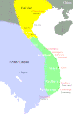
English: Southeast Asia circa 1100 C.E. showing the approximate areas of control for the Dai-Viet (Vietnam), Champa, and Khmer Empires. Note: Control of the regions away from the coast of Vietnam was more nominal than real except along the Red River.
Dai VietChampa Khmer |
||||||||
| উৎস |
|
||||||||
| লেখক | Created by CGlassey, based on maps found in DK Atlas of World History and the Times Atlas of World History. | ||||||||
| অনুমতি (এ ফাইলের পুনঃব্যবহার) |
আমি, এই কাজের স্বত্বাধিকারী, এতদ্দ্বারা আমি এই কাজকে নিম্ন বর্ণিত লাইসেন্সের আওতায় প্রকাশ করলাম:
এই ফাইলটি ক্রিয়েটিভ কমন্স অ্যাট্রিবিউশন ২.৫ জেনেরিক লাইসেন্সের আওতায় লাইসেন্সকৃত।
আপনি আপনার পছন্দসই লাইসেন্স নির্বাচন করতে পারেন। |
||||||||
| অন্যান্য সংস্করণ |
|


ফাইলের ইতিহাস
যেকোনো তারিখ/সময়ে ক্লিক করে দেখুন ফাইলটি তখন কী অবস্থায় ছিল।
| তারিখ/সময় | সংক্ষেপচিত্র | মাত্রা | ব্যবহারকারী | মন্তব্য | |
|---|---|---|---|---|---|
| বর্তমান | ০৪:৫৮, ৫ জুলাই ২০২০ | | ৪২৫ × ৭০৬ (২৭ কিলোবাইট) | Sgnpkd (আলোচনা | অবদান) | Updates on sites |
| ২১:৩৮, ২০ জানুয়ারি ২০০৯ |  | ৪২৫ × ৬৬৬ (৮ কিলোবাইট) | Gryffindor (আলোচনা | অবদান) | {{Information |Description= |Source=Own work by uploader |Date= |Author=Gryffindor |Permission= |other_versions= }} | |
| ২১:১৫, ২০ জানুয়ারি ২০০৯ |  | ৪২৫ × ৬৬৬ (৯ কিলোবাইট) | Gryffindor (আলোচনা | অবদান) | {{Information |Description= |Source=Own work by uploader |Date= |Author=Gryffindor |Permission= |other_versions= }} | |
| ২১:৩১, ৭ ডিসেম্বর ২০০৬ |  | ৪২৫ × ৬৬৬ (৯ কিলোবাইট) | Electionworld (আলোচনা | অবদান) | {{ew|en|Cglassey}} South East Asia circa 1100 C.E. showing the approximate areas of control for the Dai-Viet (Vietnam), Champa, and Khmer Empires. Note: Control of the regions away from the coast of Vietnam was more nominal than real except along the Red |
আপনি এই ফাইলটি প্রতিস্থাপন করতে পারবেন না।
ফাইলের ব্যবহার
নিম্নলিখিত 2টি পাতা এই ফাইল ব্যবহার করে:
ফাইলের বৈশ্বিক ব্যবহার
নিচের অন্যান্য উইকিগুলো এই ফাইলটি ব্যবহার করে:
- ace.wikipedia.org-এ ব্যবহার
- ar.wikipedia.org-এ ব্যবহার
- azb.wikipedia.org-এ ব্যবহার
- bn.wikipedia.org-এ ব্যবহার
- ceb.wikipedia.org-এ ব্যবহার
- ce.wikipedia.org-এ ব্যবহার
- cs.wikipedia.org-এ ব্যবহার
- da.wikipedia.org-এ ব্যবহার
- en.wikipedia.org-এ ব্যবহার
- eo.wikipedia.org-এ ব্যবহার
- fa.wikipedia.org-এ ব্যবহার
- fi.wikipedia.org-এ ব্যবহার
- fi.wikibooks.org-এ ব্যবহার
- fr.wikipedia.org-এ ব্যবহার
- he.wikipedia.org-এ ব্যবহার
- hi.wikipedia.org-এ ব্যবহার
- hu.wikipedia.org-এ ব্যবহার
- id.wikipedia.org-এ ব্যবহার
- io.wikipedia.org-এ ব্যবহার
- it.wikipedia.org-এ ব্যবহার
- ja.wikipedia.org-এ ব্যবহার
- km.wikipedia.org-এ ব্যবহার
- ko.wikipedia.org-এ ব্যবহার
- lt.wikipedia.org-এ ব্যবহার
- min.wikipedia.org-এ ব্যবহার
- ml.wikipedia.org-এ ব্যবহার
- ms.wikipedia.org-এ ব্যবহার
- new.wikipedia.org-এ ব্যবহার
- nl.wikipedia.org-এ ব্যবহার
- no.wikipedia.org-এ ব্যবহার
এই ফাইলের অন্যান্য বৈশ্বিক ব্যবহার দেখুন।