File:VietnameseProvincesMap.png
Fitxer original (428 × 713 píxels, mida del fitxer: 29 Ko, tipus MIME: image/png)
Llegendes
Llegendes

|
Aquesta imatge (de tipus locator map) s'hauria de tornar a crear utilitzant gràfics vectorials com ara un fitxer SVG. Això té diversos avantatges; en trobareu més informació a Commons:Media for cleanup. Si ja disposeu d'una versió d'aquesta imatge en format SVG, us preguem que la pengeu; després, reemplaceu aquesta plantilla amb la plantilla {{Vector version available|nom nou de la imatge.svg}} en aquesta imatge.
|
Original at: w:Image:VietnameseProvincesMap.png, where it says:
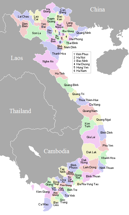
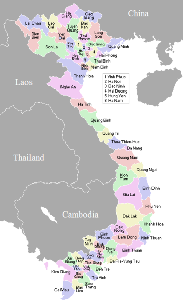
A map showing the borders and names of the Vietnamese provinces (including the changes approved in Nov 2003)
This country locator map was created by Vardion and is released into the public domain.
So this map is up to date as per current situation Waerth 07:19, 17 Mar 2005 (UTC)
See vi:Image:VietnameseProvincesMapTiengViet.png for the same map with the correctly accented Vietnamese names.
| Jo, el titular del copyright d'aquesta obra, l'allibero al domini públic. Això s'aplica a tot el món. En alguns països això pot no ser legalment possible, en tal cas: Jo faig concessió a tothom del dret d'usar aquesta obra per a qualsevol propòsit, sense cap condició llevat d'aquelles requerides per la llei. |
Historial del fitxer
Cliqueu una data/hora per veure el fitxer tal com era aleshores.
| Data/hora | Miniatura | Dimensions | Usuari/a | Comentari | |
|---|---|---|---|---|---|
| actual | 02:56, 2 nov 2007 | | 428 × 713 (29 Ko) | Vietlong (discussió | contribucions) | Reverted to version as of 11:41, 30 August 2006 |
| 11:47, 30 ago 2006 |  | 428 × 713 (25 Ko) | Vietlong (discussió | contribucions) | Reverted to earlier revision | |
| 11:41, 30 ago 2006 |  | 428 × 713 (29 Ko) | Vietlong (discussió | contribucions) | Correcting the boundary between Lai Chau and Lao Cai provinces | |
| 21:58, 20 gen 2006 |  | 428 × 713 (25 Ko) | Vardion (discussió | contribucions) | correcting boundary between Dien Bien and Lai Chau provinces | |
| 05:55, 18 abr 2005 |  | 428 × 713 (25 Ko) | Vardion (discussió | contribucions) | fixing error | |
| 07:17, 17 març 2005 |  | 428 × 713 (25 Ko) | Waerth (discussió | contribucions) | {{PD}} |
No podeu sobreescriure aquest fitxer.
Ús del fitxer
Les 2 pàgines següents utilitzen aquest fitxer:
Ús global del fitxer
Utilització d'aquest fitxer en altres wikis:
- Utilització a ace.wikipedia.org
- Utilització a ar.wikipedia.org
- Utilització a ba.wikipedia.org
- Utilització a bg.wiktionary.org
- Utilització a blk.wikipedia.org
- Utilització a bn.wikipedia.org
- Utilització a ca.wikipedia.org
- Utilització a ce.wikipedia.org
- Utilització a da.wikipedia.org
- Utilització a en.wikipedia.org
- Utilització a fa.wikipedia.org
- Utilització a fi.wikipedia.org
- Utilització a gl.wikipedia.org
- Utilització a id.wikipedia.org
- Utilització a it.wikipedia.org
- Utilització a kk.wikipedia.org
- Utilització a krc.wikipedia.org
- Utilització a kv.wikipedia.org
- Utilització a lt.wikipedia.org
- Utilització a lv.wikipedia.org
- Utilització a map-bms.wikipedia.org
- Utilització a ms.wikipedia.org
- Utilització a my.wikipedia.org
- Utilització a nl.wikipedia.org
- Utilització a no.wikipedia.org
- Utilització a os.wikipedia.org
- Utilització a pam.wikipedia.org
- Utilització a pl.wikipedia.org
- Utilització a pt.wikipedia.org
- Utilització a roa-tara.wikipedia.org
- Utilització a ru.wikipedia.org
- Utilització a su.wikipedia.org
- Utilització a sv.wikipedia.org
- Utilització a tr.wikipedia.org
Vegeu més usos globals d'aquest fitxer.