File:Vista de Puno y el Titicaca, Perú, 2015-08-01, DD 53-54 PAN.JPG

原始檔案 (10,214 × 4,096 像素,檔案大小:9.82 MB,MIME 類型:image/jpeg)
說明
說明
摘要[編輯]
| 描述 |
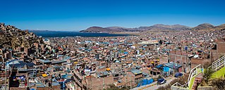
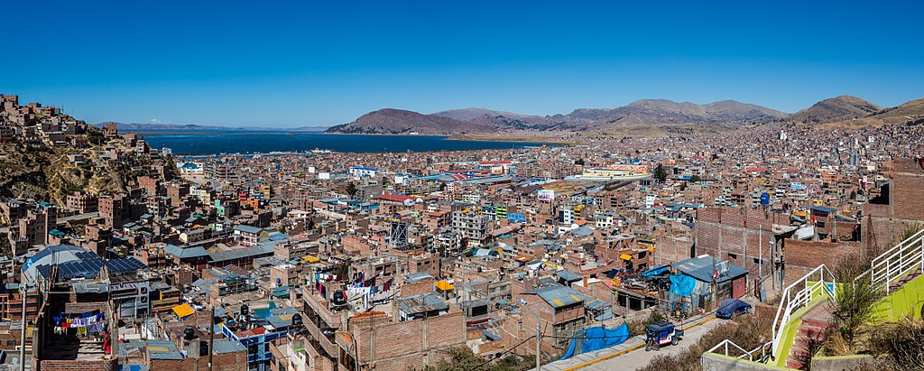
English: Panoramic view of the city of Puno next to the Lake Titicaca, in the Peruvian Andes, not far from Bolivia. Puno is the capital city of the Puno Province and has a population of approx. 150,000. It was established in 1668 by the Spanish nobleman and viceroy Pedro Antonio Fernández de Castro. The lake is, by volume of water, the largest in South America and, with a surface elevation of 3,812 metres (12,507 ft), it's considered the highest navigable lake in the world. The lake has a max. length of 190 kilometres (120 mi) and width of 80 kilometres (50 mi) and a surface of 8,372 square kilometres (3,232 sq mi), whereas the water volume is 893 cubic kilometres (214 cu mi) with a max. depth of 281 metres (922 ft) and an average depth of 107 metres (351 ft). Español: Vista panorámica de la ciudad de Puno y del lago Titicaca, Andes peruanos, no lejos de Bolivia. Puno es la capital de la Provincia de Puno y tiene una población de aprox. 150.000. El entonces vicerrey de Perú, Pedro Antonio Fernández de Castro fundó la ciudad en 1668. El lago es, por volumen de agua, el mayor en Sudamérica y, a una altura sobre el nivel del mar de 3812 m, se le considera el lago navegable más elevado del mundo. El lago tiene una longitud máxima de 190 km, una anchura de 80 km y una superficie total de 8.372 km2, mientras que el volumen de agua que aloja es de 893 km3 y su profundidad máxima es de 281 m, pero con una profundidad media de 107 m.
Français : Vue panoramique de la ville péruvienne de Puno, près du lac Titicaca dans la cordillère des Andes, non loin de la frontière bolivienne. Fondée en 1668 par le noble espagnol et vice-roi du Pérou, Pedro Antonio Fernández de Castro, Puno est la capitale de la province du même nom et abrite environ 150 000 habitants. Le lac Titicaca est, quant à lui, le plus large d'Amérique du Sud en volume d'eau. Situé à 3 812 mètres, c'est aussi le plus haut lac navigable au monde.
Magyar: Puno városának, Puno megye székhelyének panorámája. A város a Titicaca-tó partján, a perui Andokban, Bolívia közelében fekszik. Lakossága megközelítőleg 150.000 fő. 1668-ban Pedro Antonio Fernández de Castro, a spanyol nemes és alkirály alapította. A tó vízmennyiség tekintetében Dél-Amerikában a legnagyobb, és 3812 méter tengerszint feletti magasságával a világ legmagasabban fekvő hajózható tava. A tó maximális hossza 190 kilométer, szélessége 80 kilométer, a felszíne 8372 négyzetkilométer. A vízmennyisége 893 köbkilométer, legnagyobb mélysége 281 méter, átlagos mélysége 107 méter
Nederlands: Blik over de Peruaanse stad Puno, gelegen aan het Titicacameer, het grootste meer van Zuid-Amerika
Português: Vista panorâmica da cidade de Puno e do lago Titicaca, nos Andes peruanos, não muito distante da Bolívia. Puno é a capital da província de Puno e tem uma população aproximada de 150 000 habitantes. O então vice-rei do Peru, Pedro Antonio Fernández de Castro, fundou a cidade em 1668. O lago é, por volume de água, o maior da América do Sul e, com a altitude de 3 812 m, é considerado o lago navegável mais elevado do mundo. Tem um comprimento máximo de 190 km, uma largura de 80 km e uma superfície total de 8 372 km2. Seu volume de água é de 893 quilômetros cúbicos km3, sua profundidade máxima é de 281 m, com uma profundidade média de 107 m
Эрзянь: Пуно ошонть лангс келейванмось Титикака эрькенть вакссо, перунь Андатнесэ, Боливиянь аволь васоло. Пуно - те Пуно провинциянть прявтош 150,000 эриця марто. Ульнесь стявтозь-путозь 1668 иестэ Педро Антонио Фернандес де Кастро испанонь инязор-полавтыцясонть. Те эрькесь ведень покшолманзо коряс сех покш Лембеёнкс Америкасо, сэрезэ 3,812 metres (12,507 ft) иневедень чаво тешксэнь видс. Эрькенть кувалмозо 190 kilometres (120 mi), келезэ 80 kilometres (50 mi), ды вельтявксонть покшолмась 8,372 square kilometres (3,232 sq mi). Веденть ламочись 893 cubic kilometres (214 cu mi), сех домкав таркат 281 metres (922 ft) ды куншка домкась 107 metres (351 ft). |
||||||||||||||||||||
| 日期 | 攝於2015年八月1日, 13:34:44 | ||||||||||||||||||||
| 來源 | 自己的作品 | ||||||||||||||||||||
| 作者 |
|
||||||||||||||||||||

評價[編輯]
|
This image was selected as picture of the day on Wikimedia Commons for 9 October 2020. It was captioned as follows: English: Panoramic view of the city of Puno next to the Lake Titicaca, in the Peruvian Andes, not far from Bolivia. Puno is the capital city of the Puno Province and has a population of approx. 150,000. It was established in 1668 by the Spanish nobleman and viceroy Pedro Antonio Fernández de Castro. The lake is, by volume of water, the largest in South America and, with a surface elevation of 3,812 metres (12,507 ft), is considered the highest navigable lake in the world. The lake has a maximum length of 190 kilometres (120 mi), a maximum width of 80 kilometres (50 mi), and a surface area of 8,372 square kilometres (3,232 sq mi). The water volume is 893 cubic kilometres (214 cu mi), with a maximum depth of 281 metres (922 ft) and an average depth of 107 metres (351 ft). Other languages:
English: Panoramic view of the city of Puno next to the Lake Titicaca, in the Peruvian Andes, not far from Bolivia. Puno is the capital city of the Puno Province and has a population of approx. 150,000. It was established in 1668 by the Spanish nobleman and viceroy Pedro Antonio Fernández de Castro. The lake is, by volume of water, the largest in South America and, with a surface elevation of 3,812 metres (12,507 ft), is considered the highest navigable lake in the world. The lake has a maximum length of 190 kilometres (120 mi), a maximum width of 80 kilometres (50 mi), and a surface area of 8,372 square kilometres (3,232 sq mi). The water volume is 893 cubic kilometres (214 cu mi), with a maximum depth of 281 metres (922 ft) and an average depth of 107 metres (351 ft). Español: Vista panorámica de la ciudad de Puno y del lago Titicaca, Andes peruanos, no lejos de Bolivia. Puno es la capital de la Provincia de Puno y tiene una población de aprox. 150.000. El entonces vicerrey de Perú, Pedro Antonio Fernández de Castro fundó la ciudad en 1668. El lago es, por volumen de agua, el mayor en Sudamérica y, a una altura sobre el nivel del mar de 3812 m, se le considera el lago navegable más elevado del mundo. El lago tiene una longitud máxima de 190 km, una anchura de 80 km y una superficie total de 8.372 km2, mientras que el volumen de agua que aloja es de 893 km3 y su profundidad máxima es de 281 m, pero con una profundidad media de 107 m. Français : Vue panoramique de la ville péruvienne de Puno, près du lac Titicaca dans la cordillère des Andes. Fondée en 1668, Puno est la capitale de la province du même nom et abrite environ 150 000 habitants. Le lac Titicaca est, quant à lui, le plus large d'Amérique du Sud en volume d'eau. Situé à 3 812 mètres, c'est aussi le plus haut lac navigable au monde. Magyar: Puno városának, Puno megye székhelyének panorámája. A város a Titicaca-tó partján, a perui Andokban, Bolívia közelében fekszik. Lakossága megközelítőleg 150.000 fő. 1668-ban Pedro Antonio Fernández de Castro, a spanyol nemes és alkirály alapította. A tó vízmennyiség tekintetében Dél-Amerikában a legnagyobb, és 3812 méter tengerszint feletti magasságával a világ legmagasabban fekvő hajózható tava. A tó maximális hossza 190 kilométer, szélessége 80 kilométer, a felszíne 8372 négyzetkilométer. A vízmennyisége 893 köbkilométer, legnagyobb mélysége 281 méter, átlagos mélysége 107 méter Nederlands: Blik over de Peruaanse stad Puno, gelegen aan het Titicacameer, het grootste meer van Zuid-Amerika Português: Vista panorâmica da cidade de Puno e do lago Titicaca, nos Andes peruanos, não muito distante da Bolívia. Puno é a capital da província de Puno e tem uma população aproximada de 150 000 habitantes. O então vice-rei do Peru, Pedro Antonio Fernández de Castro, fundou a cidade em 1668. O lago é, por volume de água, o maior da América do Sul e, com a altitude de 3 812 m, é considerado o lago navegável mais elevado do mundo. Tem um comprimento máximo de 190 km, uma largura de 80 km e uma superfície total de 8 372 km2. Seu volume de água é de 893 quilômetros cúbicos km3, sua profundidade máxima é de 281 m, com uma profundidade média de 107 m |
授權條款[編輯]
Another one of my pictures: Want to see more works of mine? click here |
Under this condition:
Please, use this work legally fulfilling the terms of the license! Please, let me know if you use this work outside Wikimedia Commons sending me an email on Furthermore, if you:
please, do not hesitate to contact me. |

|
Please do not overwrite the author's version with a modified image without discussing with the author. The author would like to make corrections only from the uncompressed RAW file. This ensures that changes are preserved and are based on the best possible source to achieve a high quality. If you think that changes are required, please, get in touch with the author. Otherwise, you can upload a new image with a different name without overwriting this one. Use {{Derived from}} or {{Extracted from}} for this purpose. |
- 您可以自由:
- 分享 – 複製、發佈和傳播本作品
- 重新修改 – 創作演繹作品
- 惟需遵照下列條件:
- 姓名標示 – 您必須指名出正確的製作者,和提供授權條款的連結,以及表示是否有對內容上做出變更。您可以用任何合理的方式來行動,但不得以任何方式表明授權條款是對您許可或是由您所使用。
- 相同方式分享 – 如果您利用本素材進行再混合、轉換或創作,您必須基於如同原先的相同或兼容的條款,來分布您的貢獻成品。
檔案歷史
點選日期/時間以檢視該時間的檔案版本。
| 日期/時間 | 縮圖 | 尺寸 | 用戶 | 備註 | |
|---|---|---|---|---|---|
| 目前 | 2018年2月27日 (二) 19:28 | 10,214 × 4,096(9.82 MB) | Poco a poco(對話 | 貢獻) | Perspective/tilt | |
| 2018年2月17日 (六) 16:17 | 10,508 × 4,214(10.34 MB) | Poco a poco(對話 | 貢獻) | Curves, perspective | ||
| 2015年9月13日 (日) 21:36 | 10,508 × 4,214(10.62 MB) | Poco a poco(對話 | 貢獻) | User created page with UploadWizard |
無法覆蓋此檔案。
檔案用途
下列33個頁面有用到此檔案:
- User:Bennylin/Cityscapes
- User:Eatcha/POTY-2018-Round-1-Results
- User:Nardog/PotY
- User:Poco a poco/Panoramas
- User talk:Ikan Kekek/archive
- User talk:Poco a poco/2018-03
- User talk:Poco a poco/2020-10
- Commons:Featured picture candidates/File:Vista de Puno y el Titicaca, Perú, 2015-08-01, DD 53-54 PAN.JPG
- Commons:Featured picture candidates/Log/March 2018
- Commons:Featured pictures/Places/Architecture/Cityscapes
- Commons:Featured pictures/chronological/2018-A
- Commons:Picture of the Year/2018/Candidates
- Commons:Picture of the Year/2018/R1/Gallery/2018-A
- Commons:Picture of the Year/2018/R1/Gallery/ALL
- Commons:Picture of the Year/2018/R1/Gallery/M03
- Commons:Picture of the Year/2018/R1/Gallery/Panoramic views
- Commons:Picture of the Year/2018/R1/v/Vista de Puno y el Titicaca, Perú, 2015-08-01, DD 53-54 PAN.JPG
- Commons:Quality images/Subject/Architecture/Cityscapes/Archive 2018
- Commons:Quality images candidates/Archives March 01 2018
- Template:Potd/2020-10
- Template:Potd/2020-10-09
- Template:Potd/2020-10-09 (cs)
- Template:Potd/2020-10-09 (en)
- Template:Potd/2020-10-09 (es)
- Template:Potd/2020-10-09 (fr)
- Template:Potd/2020-10-09 (hu)
- Template:Potd/2020-10-09 (mk)
- Template:Potd/2020-10-09 (myv)
- Template:Potd/2020-10-09 (nl)
- Template:Potd/2020-10-09 (pt)
- Template:Potd/2020-10-09 (pt-br)
- Category:Puno
- Category:Views of Puno
全域檔案使用狀況
以下其他 wiki 使用了這個檔案:
- ar.wikipedia.org 的使用狀況
- arz.wikipedia.org 的使用狀況
- be-tarask.wikipedia.org 的使用狀況
- be.wikipedia.org 的使用狀況
- bn.wikipedia.org 的使用狀況
- ca.wikipedia.org 的使用狀況
- crh.wikipedia.org 的使用狀況
- cv.wikipedia.org 的使用狀況
- de.wikivoyage.org 的使用狀況
- en.wikivoyage.org 的使用狀況
- eo.wikipedia.org 的使用狀況
- frp.wikipedia.org 的使用狀況
- fr.wikipedia.org 的使用狀況
- fr.wikivoyage.org 的使用狀況
- ha.wikipedia.org 的使用狀況
- hr.wikipedia.org 的使用狀況
- hu.wikipedia.org 的使用狀況
- hy.wikipedia.org 的使用狀況
- it.wikivoyage.org 的使用狀況
- ja.wikivoyage.org 的使用狀況
- ka.wikipedia.org 的使用狀況
- ko.wikipedia.org 的使用狀況
- lbe.wikipedia.org 的使用狀況
- lez.wikipedia.org 的使用狀況
- mk.wikipedia.org 的使用狀況
- os.wikipedia.org 的使用狀況
- pt.wikipedia.org 的使用狀況
- qu.wikipedia.org 的使用狀況
- ro.wikipedia.org 的使用狀況
- ru.wikipedia.org 的使用狀況
- ru.wikinews.org 的使用狀況
- sah.wikipedia.org 的使用狀況
- sq.wikipedia.org 的使用狀況
- tt.wikipedia.org 的使用狀況
- uk.wikipedia.org 的使用狀況
檢視此檔案的更多全域使用狀況。