File:Voielatine planlatium.jpg
跳至導覽
跳至搜尋

預覽大小:781 × 600 像素。 其他解析度:313 × 240 像素 | 625 × 480 像素 | 1,000 × 768 像素 | 1,280 × 983 像素 | 2,560 × 1,965 像素 | 2,734 × 2,099 像素。
原始檔案 (2,734 × 2,099 像素,檔案大小:1.83 MB,MIME 類型:image/jpeg)
說明
說明
添加單行說明來描述出檔案所代表的內容
摘要
[編輯]
| 描述 |
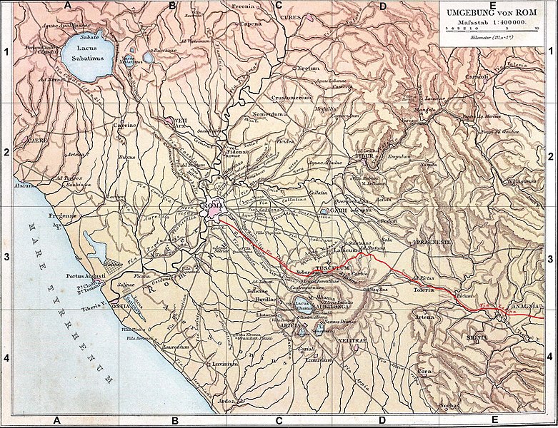
Français : Fond de carte de 1886 (G. Droysens Allgemeiner Historischer Handatlas), libre de droit (Image:Rom_Umgebung.jpg), avec la voie Latine en rouge. |
| 日期 | / 2008 |
| 來源 | Fond de carte 1886 / travail personnel (own work) |
| 作者 | ? / Coldeel |
| 其他版本 | Image:Rom_Umgebung.jpg |
授權條款
[編輯]
| 我,此作品的版權所有人,釋出此作品至公共領域。此授權條款在全世界均適用。 這可能在某些國家不合法,如果是的話: 我授予任何人有權利使用此作品於任何用途,除受法律約束外,不受任何限制。 |
檔案歷史
點選日期/時間以檢視該時間的檔案版本。
| 日期/時間 | 縮圖 | 尺寸 | 用戶 | 備註 | |
|---|---|---|---|---|---|
| 目前 | 2008年6月12日 (四) 19:54 | | 2,734 × 2,099(1.83 MB) | Coldeel(對話 | 貢獻) | {{Information |Description= |Source= |Date= |Author= |Permission= |other_versions= }} |
| 2008年6月12日 (四) 09:34 |  | 2,734 × 2,099(1.83 MB) | Coldeel(對話 | 貢獻) | {{Information |Description={{fr|1=Fond de carte de 1886 (G. Droysens Allgemeiner Historischer Handatlas), libre de droit (Image:Rom_Umgebung.jpg), avec la voie Prénestine en rouge.}} |Source=Fond de carte 1886 / travail personnel (own work) |Author= |
無法覆蓋此檔案。
檔案用途
沒有使用此檔案的頁面。
全域檔案使用狀況
以下其他 wiki 使用了這個檔案:
- de.wikipedia.org 的使用狀況
- en.wikipedia.org 的使用狀況
- fa.wikipedia.org 的使用狀況
- fr.wikipedia.org 的使用狀況
- it.wikipedia.org 的使用狀況
- mk.wikipedia.org 的使用狀況
- no.wikipedia.org 的使用狀況
- pt.wikipedia.org 的使用狀況
- ru.wikipedia.org 的使用狀況
- zh.wikipedia.org 的使用狀況