File:W-RSimpleMap.gif
跳至導覽
跳至搜尋

預覽大小:432 × 599 像素。 其他解析度:173 × 240 像素 | 346 × 480 像素 | 554 × 768 像素 | 738 × 1,024 像素 | 1,960 × 2,718 像素。
原始檔案 (1,960 × 2,718 像素,檔案大小:2.08 MB,MIME 類型:image/gif)
說明
說明
添加單行說明來描述出檔案所代表的內容
摘要
[編輯]
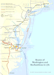
| 描述 | Official National Park Service map of the Washington-Rochambeau Revolutionary Route |
| 日期 | |
| 來源 | http://www.nps.gov/boso/w-r |
| 作者 | National Park Service |
| 授權許可 (重用此檔案) |
"The maps at this site are in the public domain. You may use National Park Service maps provided that you agree to assume complete legal responsibility for problems resulting from their use. Although National Park Service maps are easy to modify, understand that modifications can adversely alter the meaning and accuracy of the original data. Law prohibits you from using the National Park Service seal or claiming National Park Service endorsement with downloaded maps." [1] |
授權條款
[編輯]
| This image or media file contains material based on a work of a National Park Service employee, created as part of that person's official duties. As a work of the U.S. federal government, such work is in the public domain in the United States. See the NPS website and NPS copyright policy for more information. |

|
本圖片是以PNG、GIF或JPEG格式上傳。然而,其中包含的資料或訊息,應該重新建立成可縮放向量圖形(SVG)檔案,以更有效率或更準確的方式儲存。如有可能,請上傳本圖片的SVG格式版本。在上傳之後,請修改維基各姊妹計畫中所有使用舊版圖片的條目(列在圖像連結章節中),替換為新版圖片,並在舊圖片的描述頁中加入{{Vector version available|新圖片名稱.svg}}模板,同時移除本模板。
|
檔案歷史
點選日期/時間以檢視該時間的檔案版本。
| 日期/時間 | 縮圖 | 尺寸 | 用戶 | 備註 | |
|---|---|---|---|---|---|
| 目前 | 2008年4月13日 (日) 19:39 | | 1,960 × 2,718(2.08 MB) | Evrik(對話 | 貢獻) | == Summary == {{Information |Description = Official National Park Service map of the Washington-Rochambeau Revolutionary Route |Source = [http://www.nps.gov/boso/w-r] |Date = |
無法覆蓋此檔案。
檔案用途
全域檔案使用狀況
以下其他 wiki 使用了這個檔案:
- ca.wikipedia.org 的使用狀況
- el.wikipedia.org 的使用狀況
- en.wikipedia.org 的使用狀況
- Newport, Rhode Island
- Siege of Yorktown
- Jean-Baptiste Donatien de Vimeur, comte de Rochambeau
- James Manning (minister)
- France in the American Revolutionary War
- Yorktown campaign
- Washington–Rochambeau Revolutionary Route
- March Route of Rochambeau's Army: Scotland Road
- Fourth Camp of Rochambeau's Army
- March Route of Rochambeau's Army: Manship Road-Barstow Road
- March Route of Rochambeau's Army: Palmer Road
- March Route of Rochambeau's Army: Plainfield Pike
- March Route of Rochambeau's Army: Bailey Road
- March Route of Rochambeau's Army: Reservoir Road
- March Route of Rochambeau's Army: Ridgebury Road
- List of historic sites preserved along Rochambeau's route
- User:Ile da france b17/sandbox
- en.wikivoyage.org 的使用狀況
- es.wikipedia.org 的使用狀況
- fa.wikipedia.org 的使用狀況
- fr.wikipedia.org 的使用狀況
- it.wikipedia.org 的使用狀況
- ja.wikipedia.org 的使用狀況
- ko.wikipedia.org 的使用狀況
- pt.wikipedia.org 的使用狀況
- ru.wikipedia.org 的使用狀況
- www.wikidata.org 的使用狀況
- zh.wikipedia.org 的使用狀況