File:WW2-Holocaust-Europe DE.png
Zur Navigation springen
Zur Suche springen
Größe dieser Vorschau: 721 × 600 Pixel. Weitere Auflösungen: 289 × 240 Pixel | 577 × 480 Pixel | 923 × 768 Pixel | 1.231 × 1.024 Pixel | 1.310 × 1.090 Pixel.
Originaldatei (1.310 × 1.090 Pixel, Dateigröße: 802 KB, MIME-Typ: image/png)
Bildtexte
Kurzbeschreibungen
Ergänze eine einzeilige Erklärung, was diese Datei darstellt.
| Beschreibung |
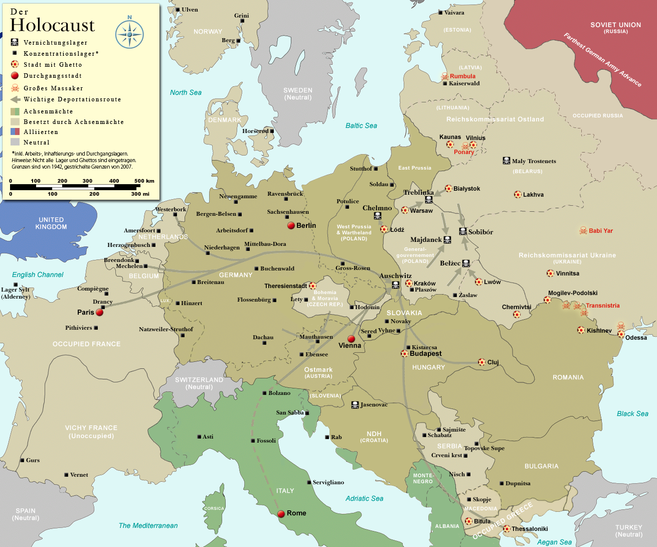
English: Map of the Holocaust in Europe during World War II, 1939-1945. This map shows all extermination camps (or death camps), most major concentration camps, labor camps, prison camps, ghettos, major deportation routes and major massacre sites. Notes: 1. Extermination camps were dedicated death camps, but all camps and ghettos took a toll of many, many lives. 2. Concentration camps include labor camps, prison camps & transit camps. 3. Not all camps & ghettos are shown. 4. Borders are at the height of Axis domination (1942). 5. Some regions have German designations (e.g. "Ostland"), with the present country name denoted in uppercase letters in parenthesis below the German designation (e.g. "(AUSTRIA)"). 6. Present (2007) borders are dotted. |
| Datum | (UTC) |
| Quelle | |
| Urheber |
|
| Andere Versionen |
[]
|


.png)


.png)


| Dieses Bild wurde digital nachbearbeitet. Folgende Änderungen wurden vorgenommen: german legend. Das Originalbild kann hier eingesehen werden: WW2-Holocaust-Europe.png:
|
Ich, der Urheber dieses Werkes, veröffentliche es unter der folgenden Lizenz:
Diese Datei ist unter der Creative-Commons-Lizenz „Namensnennung 3.0 nicht portiert“ lizenziert.
- Dieses Werk darf von dir
- verbreitet werden – vervielfältigt, verbreitet und öffentlich zugänglich gemacht werden
- neu zusammengestellt werden – abgewandelt und bearbeitet werden
- Zu den folgenden Bedingungen:
- Namensnennung – Du musst angemessene Urheber- und Rechteangaben machen, einen Link zur Lizenz beifügen und angeben, ob Änderungen vorgenommen wurden. Diese Angaben dürfen in jeder angemessenen Art und Weise gemacht werden, allerdings nicht so, dass der Eindruck entsteht, der Lizenzgeber unterstütze gerade dich oder deine Nutzung besonders.
Ursprüngliches Datei-Logbuch[Bearbeiten]
This image is a derivative work of the following images:
- File:WW2-Holocaust-Europe.png licensed with Cc-by-3.0
- 2007-12-20T03:41:38Z Dna-webmaster 1310x1090 (845818 Bytes) new version without "Axis cooperating" in legend
- 2007-12-20T02:00:30Z Dna-webmaster 1310x1090 (844034 Bytes) Now entire West Prussia and Wartheland is included in the Third Reich
- 2007-12-19T16:42:15Z Dna-webmaster 1310x1090 (847461 Bytes) still not Da Vinci, but errors have been corrected (Germany borders West/East), West & East Prussia borders/coloring and Poland General Government corrected borders.
- 2007-12-17T10:46:28Z Dna-webmaster 1310x1090 (844633 Bytes) new map with 1942 borders, not Da Vinci, but here it goes...
- 2007-10-19T13:32:25Z Dna-webmaster 1310x1090 (784727 Bytes) and another update
- 2007-10-19T12:21:52Z Dna-webmaster 1310x1090 (789383 Bytes) quick fix
- 2007-10-19T12:11:07Z Dna-webmaster 1310x1090 (789413 Bytes) {{Information |Description=Map of the Holocaust in Europe during World War II, 1939-1945. This map shows all extermination camps (or ''death camps''), most major concentration camps, work camps, prison camps, ghettos, major
Hochgeladen mit derivativeFX
Dateiversionen
Klicke auf einen Zeitpunkt, um diese Version zu laden.
| Version vom | Vorschaubild | Maße | Benutzer | Kommentar | |
|---|---|---|---|---|---|
| aktuell | 21:54, 21. Jul. 2009 | | 1.310 × 1.090 (802 KB) | Emdee (Diskussion | Beiträge) | argh |
| 21:44, 21. Jul. 2009 |  | 1.310 × 1.090 (802 KB) | Emdee (Diskussion | Beiträge) | {{Information |Description={{en|Map of the Holocaust in Europe during World War II, 1939-1945. <br /> This map shows all extermination camps (or ''death camps''), most major concentration camps, labor camps, prison camps, ghettos, major deportation routes |
Du kannst diese Datei nicht überschreiben.
Dateiverwendung
Die folgenden 24 Seiten verwenden diese Datei:
- File:WW2-Holocaust-Europe-2007Borders.png
- File:WW2-Holocaust-Europe-2007Borders DE.png
- File:WW2-Holocaust-Europe-he.png
- File:WW2-Holocaust-Europe.png
- File:WW2-Holocaust-Europe DE.png
- File:WW2-Holocaust-Europe DE 2.png
- File:WW2-Holocaust-Europe blank.png
- File:WW2-Holocaust-Poland-ru.png
- File:WW2-Holocaust-Poland-ukr.jpg
- File:WW2-Holocaust-Poland.PNG
- File:WW2-Holocaust-Poland (Français).png
- File:WW2-Holocaust-Poland (without comment).png
- File:WW2-Holocaust-Poland big legend.PNG
- File:WW2-Zagłada-Żydów-Polska.png
- File:WW2 Holocaust Europe N-E map-fr.svg
- File:WW2 Holocaust Europe map-blank.svg
- File:WW2 Holocaust Europe map-es.svg
- File:WW2 Holocaust Europe map-fr.svg
- File:WW2 Holocaust Europe map-it.svg
- File:WW2 Holocaust Europe map-pt.svg
- File:WW2 Holocaust Europe map-zh-hans.svg
- File:WW2 Holocaust Poland map-fr.svg
- File:Холокост в Европе.png
- Template:Other versions/WW2 Holocaust Europe map
Globale Dateiverwendung
Die nachfolgenden anderen Wikis verwenden diese Datei:
- Verwendung auf de.wikipedia.org
- Verwendung auf uk.wikipedia.org