File:Wagah-Attari (OpenStreetMap).png
Aller à la navigation
Aller à la recherche

Taille de cet aperçu : 800 × 511 pixels. Autres résolutions : 320 × 204 pixels | 640 × 409 pixels.
Fichier d’origine (940 × 600 pixels, taille du fichier : 108 kio, type MIME : image/png)
Légendes
Légendes
Ajoutez en une ligne la description de ce que représente ce fichier
| Description |
Cette carte a été créée à partir des données du projet OpenStreetMap. Cette carte est peut-être incomplète et peut contenir des erreurs. Ne vous fiez pas uniquement à elle pour vos déplacements. |
| Date | (voir l'historique du fichier) |
| Source | Il existe probablement une [page https://wiki.openstreetmap.org/wiki/Wagah-Attari sur le wiki d'OpenStreetMap sur ce sujet : Wagah-Attari] |
| Créé par |
contributeurs d'OpenStreetMap |
| Autorisation (Réutilisation de ce fichier) |
Les données et cartes d'OpenStreetMap sont publiées sous licence Creative Commons Attribution-ShareAlike 2.0 license (CC-BY-SA 2.0). Ce fichier est disponible selon les termes de la licence Creative Commons Attribution – Partage dans les Mêmes Conditions 2.0 Générique
|
| Géoréférencement | Si c'est inapproprié, définissez warp_status = skip pour masquer. |
Description
[modifier].png&action=edit§ion=1)
- Source link: OSM map page of Wagah and Attari area. Plus source for the image in the upper corner
- Note: derivative work (addition of a map in the corner with "Wagah" and "Attari" names)
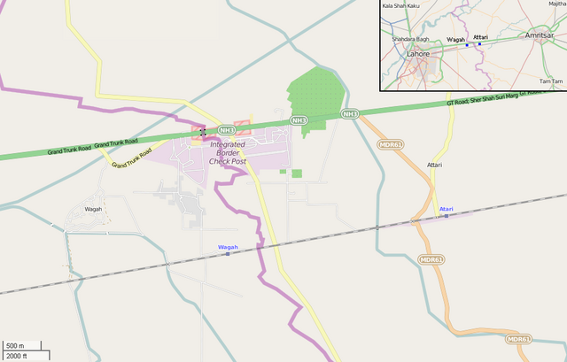
- English: Map showing the bordering villages of Wagah (Pakistan) and Attari (India). There are shown Wagah and Attari railway stations, the Indo-Pakistani border, the checkpoints and the Wagah border crossing, on the Grand Trunk Road, in which took place the Wagah border ceremony. In the upper corner is shown the position of the two villages between the cities of Lahore, Pakistan, and Amritsar, India.
Historique du fichier
Cliquer sur une date et heure pour voir le fichier tel qu'il était à ce moment-là.
| Date et heure | Vignette | Dimensions | Utilisateur | Commentaire | |
|---|---|---|---|---|---|
| actuel | 22 février 2015 à 18:15 | | 940 × 600 (108 kio) | DerBorg (d | contributions) | {{OpenStreetMap|odbl=no|name=Camagüey train station}} ==Description== {{en|Map showing the bordering villages of en:Wagah (Pakistan) and Attari (India). There are shown Wagah and [[:en:Attari railway... |
Vous ne pouvez pas remplacer ce fichier.
Utilisations locales du fichier
Les 4 pages suivantes utilisent ce fichier :
.PNG&redirect=no)
Utilisations du fichier sur d’autres wikis
Les autres wikis suivants utilisent ce fichier :
- Utilisation sur bn.wikipedia.org
- Utilisation sur ca.wikipedia.org
- Utilisation sur en.wikipedia.org
- Utilisation sur es.wikipedia.org
- Utilisation sur fa.wikipedia.org
- Utilisation sur fr.wikipedia.org
- Utilisation sur id.wikipedia.org
- Utilisation sur kn.wikipedia.org
- Utilisation sur ml.wikipedia.org
- Utilisation sur or.wikipedia.org
- Utilisation sur pa.wikipedia.org
- Utilisation sur pt.wikipedia.org
- Utilisation sur sl.wikipedia.org
- Utilisation sur ta.wikipedia.org
- Utilisation sur te.wikipedia.org
- Utilisation sur ur.wikipedia.org
- Utilisation sur www.wikidata.org
- Utilisation sur zh.wikipedia.org
.png&oldid=849689333)