File:Wandkarte von Süd-West-Deutschland.jpg
跳至導覽
跳至搜尋

預覽大小:800 × 594 像素。 其他解析度:320 × 238 像素 | 640 × 475 像素 | 1,024 × 760 像素 | 1,280 × 950 像素 | 2,560 × 1,900 像素 | 9,379 × 6,962 像素。
原始檔案 (9,379 × 6,962 像素,檔案大小:99.79 MB,MIME 類型:image/jpeg)
說明
說明
添加單行說明來描述出檔案所代表的內容
| 警告 | 部分瀏覽器在瀏覽此圖片的完整大小時可能會遇到困難:該圖片中有數量巨大的像素點,可能無法完全載入或者導致您的瀏覽器停止回應。 |
|---|
| 描述 |
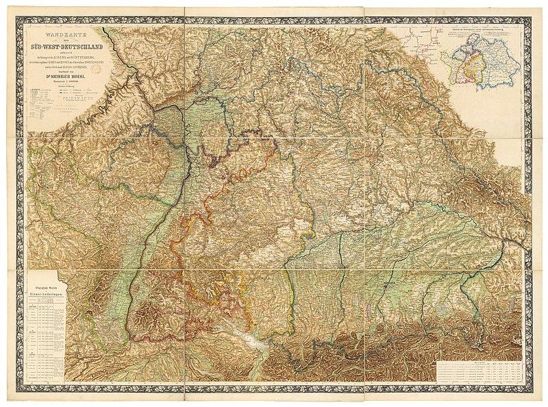
Deutsch: Wandkarte von Süd-West-Deutschland umfassend die Königreiche Bayern und Württemberg, die Grossherzogthümer Baden und Hessen, das Fürstenthum Hohenzollern und das Reichsland Elsass-Lothringen / bearbeitet von Dr. Heinrich Moehl.
English: Wall map of Southwestern Germany, which includes the Kingdom of Bavaria, Kingdom of Württemberg, the Grand Duchies of Baden and Hessen, the Principality of Hohenzollern, and the Imperial territory of Alsace-Lorraine, 1875. Edited by Dr Heinrich Moehl. |
| 日期 | |
| 來源 | Wandkarte von Süd-West-Deutschland umfassend die Königreiche Bayern und Wörttembergidie Grossherzogthümer Baden und Hessen, das Fürstenthum Hohenzollern und das Reichsland Elsass-Lothringen / bearbeitet von Dr Heinrich Moehl |
| 作者 | Moehl, Heinrich (18..-19..?). Auteur du texte ; Verlag von J.J. Tascher (Kaiserslautern) |
評價
[編輯]
This image was selected as picture of the day on Wikimedia Commons for 25 August 2012. It was captioned as follows: English: Wall map of Southwestern Germany, which includes the Kingdom of Bavaria, Württemberg Principalities of Baden and Hessen, the Principality of Hohenzollern, and the Imperial territory of Alsace-Lorraine, 1875. Restored by Dr Heinrich Moehl. Other languages:
Deutsch: Wandkarte von Süd-West-Deutschland umfassend die Königreiche Bayern und Württemberg, die Grossherzogthümer Baden und Hessen, das Fürstenthum Hohenzollern und das Reichsland Elsass-Lothringen / bearbeitet von Dr. Heinrich Moehl English: Wall map of Southwestern Germany, which includes the Kingdom of Bavaria, Württemberg Principalities of Baden and Hessen, the Principality of Hohenzollern, and the Imperial territory of Alsace-Lorraine, 1875. Restored by Dr Heinrich Moehl. Italiano: Mappa della Germania sud-occidentale con il Regno di Baviera, il Granducato di Baden, l'Hohenzollern-Hechingen e l'Alsazia-Lorena, a cura del dr. Dr Heinrich Moeh, 1875 Magyar: Délnyugat-Németország egy 1875-ös fali térképen Nederlands: Wandkaart van het zuidwesten van Duitsland met inbegrip van de koninkrijk van Beieren, Groothertogdom Baden, Groothertogdom Hessen, vorstendom Hohenzollern en het Reichsland Elzas-Lotharingen, onder de redactie van Heinrich Moehl. Русский: Настенная карта юго-западной Германии, 1875 中文: 德国西南部1875年地图,包括巴伐利亚、巴登、黑森和阿尔萨斯-洛林。 |
授權條款
[編輯]
本影像屬於公有領域,因為該影像是單純針對一件公有領域原作進行機械掃描,或(從現有證據來看)類似掃描而來的,或該重製照片可以預期不會有版權保護。原作屬於公有領域,是因下述原因:
本標籤主要用於該掃描件有可能使用任何增強功能(如亮度、對比度、色彩調整、銳利化等),而這些增強功能無法達到原創性而無法產生版權的情形下使用。而該標籤也能使用在無法判定本掃描件使用任何增強功能,以及已知使用增強功能但沒有充分證據時。對於採取原始忠實掃描而不使用增強功能的照片,可以適當採用{{PD-old}}標籤取代。對於本標籤的使用方法,參見如何使用PD-Scan標籤。  | ||||
檔案歷史
點選日期/時間以檢視該時間的檔案版本。
| 日期/時間 | 縮圖 | 尺寸 | 使用者 | 備註 | |
|---|---|---|---|---|---|
| 目前 | 2012年7月14日 (六) 18:40 | | 9,379 × 6,962(99.79 MB) | ComputerHotline(留言 | 貢獻) | {{Information |Description={{LargeImage}}{{de|Wandkarte von Süd-West-Deutschland umfassend die Königreiche Bayern und Wörttembergidie Grossherzogthümer Baden und Hessen, das Fürstenthum Hohenzollern und das Reichsland Elsass-Lothringen / bearbeite... |
無法覆蓋此檔案。
檔案用途
下列25個頁面有用到此檔案:
- User:ComputerHotline/Archive 11
- User:Ö/Best/2012
- Commons:Featured picture candidates/File:Wandkarte von Süd-West-Deutschland.jpg
- Commons:Featured picture candidates/Log/July 2012
- Commons:Featured pictures/Non-photographic media/Maps
- Commons:Featured pictures/chronological/2012-B
- Commons:Picture of the Year/2012/Galleries/2012-B
- Commons:Picture of the Year/2012/Galleries/ALL
- Commons:Picture of the Year/2012/Galleries/Index/11
- Commons:Picture of the Year/2012/Galleries/JUL
- Commons:Picture of the Year/2012/Galleries/Maps
- Commons:Picture of the Year/2012/R1/Wandkarte von Süd-West-Deutschland.jpg
- Commons:Picture of the Year/2012/Results/R1/ALL
- Commons:Picture of the Year/2012/Results/R1/ALL/gallery
- Commons:Picture of the Year/2012/Results/R1/ALL/thumbnailtable
- Commons:Picture of the Year/2012/Results/R1/Maps
- Template:Potd/2012-08
- Template:Potd/2012-08-25
- Template:Potd/2012-08-25 (de)
- Template:Potd/2012-08-25 (en)
- Template:Potd/2012-08-25 (it)
- Template:Potd/2012-08-25 (ka)
- Template:Potd/2012-08-25 (nl)
- Template:Potd/2012-08-25 (zh-hans)
- Template:Potd/2012-08 (zh-hans)
全域檔案使用狀況
以下其他 wiki 使用了這個檔案:
- be-tarask.wikipedia.org 的使用狀況
- bn.wikipedia.org 的使用狀況
- crh.wikipedia.org 的使用狀況
- cv.wikipedia.org 的使用狀況
- en.wikipedia.org 的使用狀況
- fr.wikipedia.org 的使用狀況
- hu.wikipedia.org 的使用狀況
- ka.wikipedia.org 的使用狀況
- kk.wikipedia.org 的使用狀況
- ko.wikipedia.org 的使用狀況
- krc.wikipedia.org 的使用狀況
- lbe.wikipedia.org 的使用狀況
- os.wikipedia.org 的使用狀況
- pt.wikipedia.org 的使用狀況
- ru.wikipedia.org 的使用狀況
- ru.wikinews.org 的使用狀況
- sah.wikipedia.org 的使用狀況
- uk.wikipedia.org 的使用狀況
- xal.wikipedia.org 的使用狀況
- zh.wikipedia.org 的使用狀況