File:Wappen des Landkreises Kronach.svg
Przejdź do nawigacji
Przejdź do wyszukiwania

Wielkość pliku podglądu PNG dla pliku SVG: 512 × 569 pikseli Inne rozdzielczości: 216 × 240 pikseli | 432 × 480 pikseli | 691 × 768 pikseli | 921 × 1024 pikseli | 1843 × 2048 pikseli.
Rozmiar pierwotny (Plik SVG, nominalnie 512 × 569 pikseli, rozmiar pliku: 135 KB)
Podpisy
Podpisy
Dodaj jednolinijkowe objaśnienie tego, co ten plik pokazuje
Opis
[edytuj]| Herb | ||||
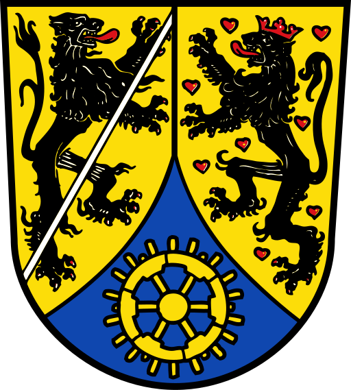
| Blazonowanie | Deutsch: „Gespalten durch eine gesenkte, aufsteigende und eingeschweifte blaue Spitze, darin ein goldenes Wasserrad; vorne in Gold ein mit einem silbernen Schrägbalken überdeckter linksgewendeter, rot bewehrter schwarzer Löwe, hinten in mit roten Herzen bestreutem goldenen Feld ein rot gekrönter und rot bewehrter schwarzer Löwe.“ |
|||
| Referencja blazonowania | ||||
| Tynktura | argentorazuregulessable |
|||
| Data | 11 kwietnia 1957 | |||
| Historia obiektu |
Deutsch: Der Landkreis Kronach erhielt am 11. April 1957 die Genehmigung des Bayerischen Staatsministeriums des Innern, das vorstehend beschriebene Wappen zu führen. Die Fortführung des Wappens genehmigte die Regierung von Oberfranken am 5. Juni 1973.
Der Landkreis Kronach hat sich im Zuge der Kreisgebietsreform von 1972 nur unwesentlich verändert. Der Kreistag hat deshalb beschlossen, das Wappen des Alt-Landkreises Kronach von 1957 unverändert anzunehmen. In der vorderen Schildhälfte steht der Bamberger Löwe. Das Land um Kronach kam 1122 durch Schenkung an das Bistum Bamberg, bei dem es bis zum Ende des Alten Reichs 1803 blieb. In der hinteren Schildhälfte steht der Löwe der Grafen von Orlamünde, die bis zu ihrem Aussterben im 15. Jahrhundert vor allem im nördlichen Kreisgebiet um Lauenstein als Herrschaftsinhaber belegt sind. Das Wasserrad stellt den Wasser- und Holzreichtum des Kreisgebiets dar. Die Farben der Spitze sind dem Wappen des einstigen Klosters Langheim entnommen, das bis 1388 das „Eigen Teuschnitz“ besaß. English: The arms were granted 11 April 1957 and confirmed 5 June 1973. The two lions are the lions of Bamberg and Orlamünde. The largest part of the district belonged since 1122 to the Bishops of Bamberg, whereas the Counts of Orlamünde owned the castle and estate of Lauenstein in the northern part of the district. The lower part shows in the colours of the Cistercian abbey of Langheim, a wheel. The wheel symbolises the forestry and many small rivers in the district, and the many water mills therein. |
|||
| Artysta | unbekannt für den Landkreis Kronach | |||
| Źródło | 2016-02-15 durch ludger1961 aus PDF extrahiert und mit Texteditor bearbeitet | |||
| Licencja (Ponowne użycie tego pliku) |
|
|||
| Inne wersje |
|


Historia pliku
Kliknij na odpowiedniej dacie/czasie, aby zobaczyć wersję pliku z tamtego okresu.
| Data/czas | Miniatura | Wymiary | Użytkownik | Opis | |
|---|---|---|---|---|---|
| aktualny | 18:03, 16 lut 2016 | | 512 × 569 (135 KB) | Ludger1961 (dyskusja | edycje) | == {{int:filedesc}} == {{COAInformation |Blazon of = {{de|1=des Landkreises Kronach, Bayern}} {{en|1=the German district of Kronach}} {{fr|1=de l’arrondissement... |
Nie możesz nadpisać tego pliku.
Lokalne wykorzystanie pliku
Następujące strony korzystają z tego pliku:
- Landkreis Kronach
- File:Banner des Landkreises Kronach.svg
- File:Hissflagge des Landkreises Kronach.svg
- File:Wappen Landkreis Kronach.png
- File:Wappen des Landkreises Kronach.svg
- Template:Municipalities in Landkreis Kronach
- Category:City gates of Kronach
- Category:Culture of Landkreis Kronach
- Category:Districts of Kronach
- Category:Districts of Küps
- Category:Districts of Ludwigsstadt
- Category:Districts of Marktrodach
- Category:Districts of Mitwitz
- Category:Districts of Nordhalben
- Category:Districts of Pressig
- Category:Districts of Schneckenlohe
- Category:Districts of Steinbach am Wald
- Category:Districts of Steinwiesen
- Category:Districts of Stockheim (Upper Franconia)
- Category:Districts of Tettau
- Category:Districts of Teuschnitz
- Category:Districts of Wallenfels
- Category:Districts of Weißenbrunn
- Category:Districts of Wilhelmsthal
- Category:Gemeindefreies Gebiet Birnbaum
- Category:Kronach
- Category:Küps
- Category:Landkreis Kronach
- Category:Langenbacher Forst
- Category:Ludwigsstadt
- Category:Maps of Landkreis Kronach
- Category:Marktrodach
- Category:Mitwitz
- Category:Nordhalben
- Category:People of Landkreis Kronach
- Category:Postcards of Kronach
- Category:Pressig
- Category:Reichenbach (Upper Franconia)
- Category:Religion in Landkreis Kronach
- Category:Schneckenlohe
- Category:Steinbach am Wald
- Category:Steinwiesen
- Category:Stockheim (Upper Franconia)
- Category:Tettau
- Category:Teuschnitz
- Category:Tschirn
- Category:Views of Landkreis Kronach
- Category:Wallenfels
- Category:Weißenbrunn
- Category:Wilhelmsthal
Globalne wykorzystanie pliku
Ten plik jest wykorzystywany także w innych projektach wiki:
- Wykorzystanie na an.wikipedia.org
- Wykorzystanie na ar.wikipedia.org
- Wykorzystanie na ceb.wikipedia.org
- Wykorzystanie na cs.wikipedia.org
- Wykorzystanie na da.wikipedia.org
- Wykorzystanie na de.wikipedia.org
- Kronach
- Liste der Landkreise in Deutschland
- Landkreis Kronach
- Vorlage:Navigationsleiste Städte und Gemeinden im Landkreis Kronach
- Festung Rosenberg
- Mitwitz
- Werner Schnappauf
- Steinbach am Wald
- Grafschaft Weimar-Orlamünde
- Weißenbrunn
- Ludwigsstadt
- Wallenfels
- Teuschnitz
- Stockheim (Oberfranken)
- Küps
- Steinwiesen
Pokaż listę globalnego wykorzystania tego pliku.