File:Wax Lake Delta.jpg
Zur Navigation springen
Zur Suche springen
Es ist keine höhere Auflösung vorhanden.
Wax_Lake_Delta.jpg (292 × 256 Pixel, Dateigröße: 84 KB, MIME-Typ: image/jpeg)
Bildtexte
Kurzbeschreibungen
Ergänze eine einzeilige Erklärung, was diese Datei darstellt.
| Beschreibung |
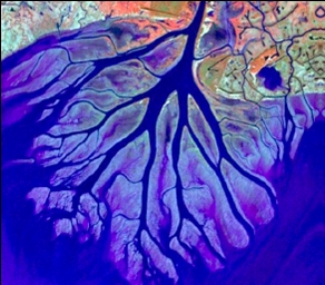
English: The Wax Lake Delta was formed by the deposition of sediment from a shipping canal off of the Atchafalaya River. The channel was routed through Wax Lake, which quickly filled with sediment. After Wax Lake filled, the sediment from the canal deposited offshore and created the delta. |
|||
| Datum | ||||
| Quelle | National Center for Earth-surface Dynamics; http://www.nced.umn.edu/printview/Field_Site_Wax_Lake_Delta | |||
| Urheber | National Center for Earth-surface Dynamics | |||
| Genehmigung (Weiternutzung dieser Datei) |
|

| Kameraposition | | Dieses und weitere Bilder auf OpenStreetMap |
|---|
Dateiversionen
Klicke auf einen Zeitpunkt, um diese Version zu laden.
| Version vom | Vorschaubild | Maße | Benutzer | Kommentar | |
|---|---|---|---|---|---|
| aktuell | 21:02, 19. Dez. 2008 | | 292 × 256 (84 KB) | Awickert (Diskussion | Beiträge) | {{Information |Description={{en|1=The Wax Lake Delta was formed by the deposition of sediment from a shipping canal off of the Atchafalaya River. The channel was routed through Wax Lake, which quickly filled with sediment. After Wax Lake filled, the sedim |
Du kannst diese Datei nicht überschreiben.
Dateiverwendung
Keine Seiten verwenden diese Datei.
Globale Dateiverwendung
Die nachfolgenden anderen Wikis verwenden diese Datei:
- Verwendung auf de.wikipedia.org
- Verwendung auf en.wikipedia.org
- Verwendung auf es.wikipedia.org
- Verwendung auf fr.wikipedia.org
- Verwendung auf www.wikidata.org